27 Sioux Avenue, Wigram
15 reports on record since August 2022 · 11 with photographs. The most-reported address on Sioux Avenue. Indicative rating valuation and school zones, hazards, bin day and what stood here before.
What gets reported here
Photographed here 11 on record



Reported here
 Dumped Rubbish —
 Dumped rubbish
 Dumped Rubbish —
 Dumped rubbish
 Overgrown Vegetation —
 Overgrown verge corner of Sioux Avenue and Hurricane Way
 Dumped Rubbish —
 Dumped rubbish (screen curtain) outside our property on Hurrican Way. This is an inevitable result of Council not mowing the berm which for
 Overgrown Vegetation —
 Grass on verge that usually mowed by Council has not been done in weeks.
 Graffiti on a sign, mural or public art —
 Tag on road sign
 Fallen Tree —
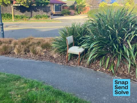
 Fallen trees and chair dumped, trees are damaged due to the repeated parking of the truck photographed, he’s well aware that he is damaging
 Park - General Request —
 The corner gardens around Sioux Ave in Wigram have a lot of Weeds
 Pavement - Damaged —
 Asphalt degrading due to weeds growing through it
 Dumped Rubbish —
 A chair has been dumped corner Sioux Avenue and Huurrucane Way
- Pavement - Damaged —
- Pavement - Damaged —
- Pavement - Damaged —
- Damaged Street Sign —
 Pavement - Damaged —
 Damaged pavement
Also reported on Sioux Avenue
- 35 Sioux Avenue — 5 reports
- 60 Sioux Avenue — 4 reports
- 54 Sioux Avenue — 4 reports
- 15 Sioux Avenue — 4 reports
- 95 Sioux Avenue — 3 reports
- 29 Sioux Avenue — 3 reports
- 21 Sioux Avenue — 3 reports
- 58 Sioux Avenue — 2 reports
The street’s crash record
NZTA’s record names Sioux Avenue in 3 crashes that hurt somebody since 2006 — 0 seriously hurt, nobody killed.
The green nearby
- Sioux Reserve — 44 m to the edge
- De Lange Reserve — 215 m to the edge
- Bennington 1 Drainage Reserve — 275 m to the edge
- Mustang 1 Drainage Reserve — 367 m to the edge
- Awatea Basin — 376 m to the edge
Parks within half a kilometre, measured to the boundary — the council’s open data.
On the doorstep
- Gorgeous Food — 280 m away · Business
- Springs Rd Takeaways — 295 m away · Fast food
- Wok Inn Chinese Takeaways — 295 m away · Fast food
- Wok Inn Fish & Chips — 299 m away · Fast food
Businesses within four hundred metres, measured at the pin — OpenStreetMap and the council directories.
The bus nearby
The closest Metro stops, within four hundred and fifty metres.
The tracks through here
- Walk and bike track through Wigram — 453 m to the line · walk · bike
Tracks whose line passes within half a kilometre, measured to the line itself — the council’s open data.
The named ground
Named water within 500 m of this address, measured to the line or the edge — the open map’s record.
Renting nearby
new bonds in Wigram ran about $697 a week — $147 above the city median of $550 — the suburb page keeps the rent record →.
The civic layer
This ground votes in Hornby ward — the Halswell-Hornby-Riccarton community board. Ward lines don’t always follow suburb lines; this one is measured at the pin, not the suburb’s centre.
What stood on this ground → · On the map → · From the air — the Crown’s aerials back to 1936; search the address on RetroLens →
Questions, answered briefly
15 council reports on record since August 2022 — most often pavement - damaged (5), dumped rubbish (4), overgrown vegetation (2).
Wigram, Christchurch — on Sioux Avenue.
Nothing on the heritage register at this exact spot — the record around this ground →
Sioux Reserve — 44 m to its edge.