690 Ferry Road, Woolston
43 reports on record since April 2016 · 35 with photographs. The street’s heaviest record is 502 Ferry Road — 59 reports on file. Indicative rating valuation and school zones, hazards, bin day and what stood here before.
What gets reported here
Photographed here 35 on record


Reported here
 Graffiti on a traffic light pole or cabinet, or wa —
 graffiti on traffic control cabinet nearby
 Graffiti on a traffic light pole or cabinet, or wa —
 graffiti on traffic control cabinet nearby
 Bus Shelter Issue —
 Rubbish is being shoved behind the bus stop in a private property. There's also tagging on the bench.
 Graffiti on a traffic light pole or cabinet, or wa —
  Graffiti on a fence, building or structure —
  Graffiti on a cabinet, pole or railway asset —
  Graffiti on a cabinet, pole or railway asset —
  Graffiti somewhere else —
  Graffiti somewhere else —
  Graffiti somewhere else —
  Graffiti somewhere else —
  Graffiti somewhere else —
  Graffiti somewhere else —
 A bunch of retarded tagging all in a row. I see yesterday's tunnel roundabout sign tag is gone already! Excellent work!
 Graffiti somewhere else —
 This cabinet had been reported many times and never gets cleaned up ???
 Graffiti somewhere else —
 Corner Rutherford St & Ferry Rd. Sorry don’t know what’s it’s on, some sort of council box?
 Graffiti somewhere else —
 On a corner street
 Graffiti somewhere else —
 Tall blue cabinet on this corner has graffiti
 Graffiti somewhere else —
 On traffic controller box
 Graffiti on a cabinet, pole or railway asset —
 Please - been a while :-)
 Graffiti on a cabinet, pole or railway asset —
 Traffic Solutions QTC cabinet crn Ferry rd and Rutherford St Woolston Susan
 Graffiti somewhere else —
 Blue cabinet on this corner has graffiti
 Graffiti on a cabinet, pole or railway asset —
  Graffiti —
 Corner Ferry and Rutherford rds 2 cabinets tagged one green and one pale blue/ grey. Susan,
 Graffiti —
  Graffiti —
 On traffic light controls
 Graffiti —
  Graffiti —
  Graffiti —
 Traffic light cabinet.
 Graffiti —
 - Graffiti —
- Graffiti —
- Graffiti —
- Graffiti —
- General Request —
- Graffiti —
- Graffiti —
- Graffiti —
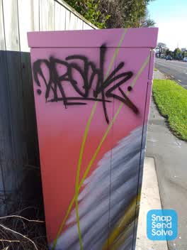 Graffiti —
 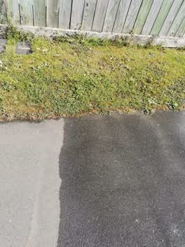 Water Leak —
 Water coming out of meter box
Roading/Streets —
orange light broken and facing wrong street
Graffiti —
Graffiti —
Graffiti —
Green box
Also reported on Ferry Road
- 502 Ferry Road — 59 reports
- 689 Ferry Road — 40 reports
- 564 Ferry Road — 33 reports
- 583 Ferry Road — 32 reports
- 800 Ferry Road — 30 reports
- 608 Ferry Road — 30 reports
- 560 Ferry Road — 30 reports
- 543 Ferry Road — 27 reports
The street’s crash record
NZTA’s record names Ferry Road in 192 crashes that hurt somebody since 2006 — 5 people killed, 43 seriously hurt.
The green nearby
- Palinurus Reserve — 68 m to the edge
- Steam Wharf Stream Reserve — 278 m to the edge
- Radley Park — 282 m to the edge · 3 ha
- Connal Reserve — 284 m to the edge · 1 ha
- Glenroy Reserve — 322 m to the edge
Parks within half a kilometre, measured to the boundary — the council’s open data.
On the doorstep
- Finders Keepers — 207 m away · Clothing
- Entente Cordiale — 230 m away · Business
- Holy Smoke Deli — 234 m away · Delis
- Lyttelton Records Events & Cafe — 234 m away · Venues & events
Businesses within four hundred metres, measured at the pin — OpenStreetMap and the council directories.
The bus nearby
- Ferry Rd near Rutherford St — 48 m away · route 3
- Ferry Rd near Palinurus Rd — 67 m away · route 3, route 155
The closest Metro stops, within four hundred and fifty metres.
The tracks through here
- Walk and bike track through Woolston — 15 m to the line · walk · bike
- Walk and bike track through Woolston — 159 m to the line · walk · bike
- Walk and bike track through Woolston — 192 m to the line · walk · bike
- Walk and bike track through Woolston — 214 m to the line · walk · bike
- Walk and bike track through Woolston — 230 m to the line · walk · bike
Tracks whose line passes within half a kilometre, measured to the line itself — the council’s open data.
The named ground
Named water within 500 m of this address, measured to the line or the edge; the council’s own structure register — bridges, boardwalks and steps standing nearby — the open map’s record.
Renting nearby
new bonds in Woolston ran about $511 a week — $39 below the city median of $550 — the suburb page keeps the rent record →.
What was here — Dwelling and Setting, Whalebone Cottage
78 m away · 704 Ferry Road · located to ±11 m · the place’s own record →
On the register. Nothing researched here yet.
What was here — Commercial Building and Setting
226 m away · 650 Ferry Road · located to ±26 m · the place’s own record →
On the register. Nothing researched here yet.
The civic layer
This ground votes in Linwood ward — the Coastal-Burwood-Linwood community board. Ward lines don’t always follow suburb lines; this one is measured at the pin, not the suburb’s centre.
What stood on this ground → · On the map → · From the air — the Crown’s aerials back to 1936; search the address on RetroLens →
Questions, answered briefly
43 council reports on record since April 2016 — most often graffiti (18), graffiti somewhere else (12), graffiti on a cabinet, pole or railway asset (5).
Woolston, Christchurch — on Ferry Road.
The heritage register names 2 places at or beside it — Dwelling and Setting, Whalebone Cottage, Commercial Building and Setting.
Palinurus Reserve — 68 m to its edge.