Christchurch North Elim Church
a Pentecostal church, Belfast
a church
The record
- The map calls it
- a Pentecostal church
- Religion
- christian
- Denomination
- Pentecostal
- Address
- 803 Main North Road
- Street
- Main North Road
- Suburb
- Belfast
- Phone
- +64 3 323 7212
In the archive
- Documents naming it on the shelf →
- The record’s own search for it →
- The suburb it stands in →
- The whole roll →
A document a search names is a lead worth reading, not a claim the site makes.
Other places of worship near it 4
The nearest other places of worship by distance, proximity on the map, not a claim of kinship.
The green nearby 1
Parks whose drawn outline sits within 400 m, measured to the outline itself, so a place on a big reserve’s edge still counts.
The register nearby 1
Heritage-register places within 300 m of the place’s point, proximity, not a claim of place.
The reports nearby
102 council reports pinned within 250 m of the place, most often Roads & footpaths and Graffiti & vandalism, 86 with a photograph. A pin is where a reporter stood, not a claim about the place itself.
 Fallen Tree
 Road Signage
 Road Signage
 Bus Shelter Issue
 Pavement - Damaged
 Bus Shelter Issue
 Bus Shelter Issue
 Damaged Road
 Bus Shelter Issue
 Bus Shelter Issue
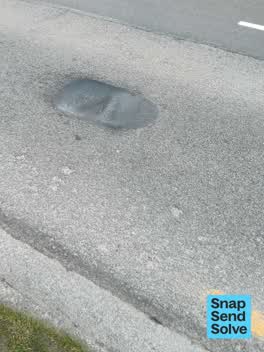 Pothole
 Street Gutters / Storm Water
Getting there
The nearest stop the Metro map carries, measured to the pin, not the door.
Questions, answered briefly
803 Main North Road, Belfast, Christchurch, on the map →.
The map calls it a Pentecostal church. That is the mapper’s tag, not this site’s own survey.
Source: OpenStreetMap way/628481070 (ODbL). A directory, not a census of faith: name, religion, denomination and address are the tags OpenStreetMap’s mappers give each place, and a tag the map does not carry stays unstated here rather than guessed from a name. A listing is a lead, not a claim, it says a place of worship is mapped on this ground, not that a congregation meets there this week. Coordinates pin the building as the map draws it.