252 Lincoln Road, Addington
23 reports on record since April 2019 · 17 with photographs. The street’s heaviest record is 355 Lincoln Road — 48 reports on file. Indicative rating valuation and school zones, hazards, bin day and what stood here before.
What gets reported here
Photographed here 17 on record


Reported here
 Traffic Signals —
 Traffic light sync, the red turning arrow is unnecessary. There are many available opportunities that prevent turning right onto lincoln rd
 Damaged Road —
 Damaged road has dangerous speed bumps causing car accidents and ruining traffic flow more are also appearing on the main roads with 90% of
 Graffiti on a fence, building or structure —
  Graffiti on a fence, building or structure —
  Road Signage —
 I’m at Barrington Street, but I had to get off my bike to find out if this was actually the name of the intersection. There is not one sign
 Graffiti on a cabinet, pole or railway asset —
 On cnr of Whiteley and Lincoln rd
 Hazard — vehicle —
 Scooter parked on sidewalk making pram / disability scooters unable to use sidewalk
 Accessibility —
 Traffic lights don't produce a sound for pedestrians to know when to cross. Can be hard for visually impaired pedestrians if relying on the
 Dumped Rubbish —
 - Pavement - General —
- Dumped Rubbish —
- Damaged Street Sign —
- Rubbish and Bins - General —
- Damaged Street Light —
- Damaged Street Light —
 Damaged Road —
 This is the result of work done as part of a current lane closure. The approach to a busy, free flowing double lane intersection now has a s
 Street Light Outage —
 Light is on in photo but it seems to be flickering on and off
Water Supply —
leaking Toby
Water Supply —
leaking Toby
Water Supply —
water leak
Water Supply —
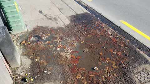
leaking water out of small round cover next to underground power cables outside 252 Lincoln Rd
Water Supply —
Graffiti —
On wall by laundromat.
Also reported on Lincoln Road
- 355 Lincoln Road — 48 reports
- 410 Lincoln Road — 42 reports
- 361 Lincoln Road — 42 reports
- 359B Lincoln Road — 39 reports
- 376 Lincoln Road — 38 reports
- 184 Lincoln Road — 34 reports
- 359 Lincoln Road — 32 reports
- 162 Lincoln Road — 30 reports
The street’s crash record
NZTA’s record names Lincoln Road in 165 crashes that hurt somebody since 2006 — 2 people killed, 45 seriously hurt.
The green nearby
- Addington Park — 102 m to the edge · Sports ground · 3 ha
- Parade Court Reserve — 116 m to the edge
- Walsall Reserve — 211 m to the edge
- Mountfort Park — 442 m to the edge · Botanic
- Longley Reserve — 442 m to the edge
Parks within half a kilometre, measured to the boundary — the council’s open data.
On the doorstep
- Z Espress - Addington — 21 m away · Fast food
- Z2O — 41 m away · Car washes
- 239 on Lincoln Motel — 42 m away · Motels
- Addington City Motel — 52 m away · Motels
Businesses within four hundred metres, measured at the pin — OpenStreetMap and the council directories.
The bus nearby
- Lincoln Rd near Parade Ct — 77 m away · route 7
- Whiteleigh Ave near Barrington St — 117 m away · route 120, the Orbiter (clockwise)
The closest Metro stops, within four hundred and fifty metres.
The tracks through here
- Walk and bike track through Addington — 17 m to the line · walk · bike
- Walk and bike track through Addington — 24 m to the line · walk · bike
- Walk and bike track through Addington — 34 m to the line · walk · bike
- Walk and bike track through Addington — 148 m to the line · walk · bike
- Walk and bike track through Addington — 486 m to the line · walk · bike
Tracks whose line passes within half a kilometre, measured to the line itself — the council’s open data.
The named ground
Named water within 500 m of this address, measured to the line or the edge; Named places within 1.5 km of this address; the council’s own structure register — bridges, boardwalks and steps standing nearby — the open map’s record.
Renting nearby
new bonds in Addington ran about $502 a week — $48 below the city median of $550 — the suburb page keeps the rent record →.
What was here — Dwelling and Setting
158 m away · 13 Spencer Street · located to ±12 m · the place’s own record →
On the register. Nothing researched here yet.
The civic layer
This ground votes in Spreydon ward — the Spreydon-Cashmere-Heathcote community board. Ward lines don’t always follow suburb lines; this one is measured at the pin, not the suburb’s centre.
What stood on this ground → · On the map → · From the air — the Crown’s aerials back to 1936; search the address on RetroLens →
Questions, answered briefly
23 council reports on record since April 2019 — most often water supply (5), graffiti on a fence, building or structure (2), dumped rubbish (2).
Addington, Christchurch — on Lincoln Road.
The heritage register names a place at or beside it — Dwelling and Setting.
Addington Park — 102 m to its edge, 3 ha.