11 Rue Noyer
3 council reports since November 2016, 3 carrying a photograph. The street’s heaviest record is 9 Rue Noyer, 4 reports on file.
The green nearby
- Stanley Park, 81 m to the edge · 7 ha
- Bercusson Reserve, 178 m to the edge
- Hutchenson Reserve, 198 m to the edge · 1 ha
- Walnut Place Reserve, 260 m to the edge
- Akaroa Beach, 353 m to the edge · 1 ha
Parks within half a kilometre, measured to the boundary, the council’s open data. The whole roll is at /parks.
The civic shelf nearby
- Akaroa Library, 262 m away · Library
Libraries, halls and the rest within half a kilometre, the council’s open data.
On the doorstep
- Akaroa Cinema, 174 m away · Cinemas & theatres
- Akaroa Cinemas and Café, 225 m away · Cafés
- Cine Cafe Akaroa, 240 m away · Cinemas & theatres
- French Bay House Bed and Breakfast, 275 m away · Guest houses
Businesses within four hundred metres, measured at the pin, OpenStreetMap and the council directories.
The named ground
Named water within 500 m of this address, measured to the line or the edge; Named places within 1.5 km of this address; the council’s own structure register, bridges, boardwalks and steps standing nearby, the open map’s record.
What gets reported here
- Water Supply, 1
- Fallen Tree, 1
- Damaged Road, 1
Photographed here 3 on record


What’s on record
 Damaged Road, 23 Feb 2026
 One neighbor took it upon himself to grate the road with a digger, and made it even worse that before. On top of, the recent weather event c
 Fallen Tree, 25 Nov 2025
 Two trees fell during last storm and are across the stream and landed in our garden. They are located on rue Noyer, so on public land, there
Water Supply, 24 Nov 2016
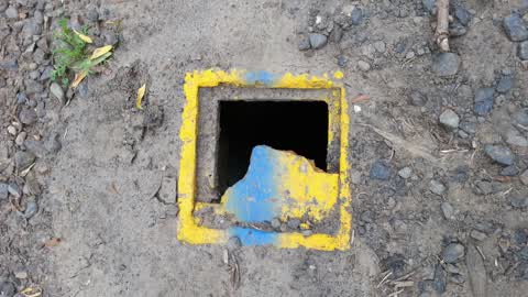
Broken lid on valve? Box. Roughly 120 mm2. In middle of track/drive. Maybe private?
Elsewhere on Rue Noyer
- 9 Rue Noyer, 4 reports
- 3 Rue Noyer, 4 reports
- 7 Rue Noyer, 1 report
The civic layer
This ground votes in Banks Peninsula ward, the Banks Peninsula community board is its local layer. Ward lines don’t always follow suburb lines; this one is measured at the pin, not the suburb’s centre. The whole roll is at /wards.
Rue Noyer, the whole record → · Everything about Akaroa → · What stood on this ground → · On the map → · From the air, RetroLens holds the Crown’s aerials back to 1936; search the address there →
Questions, answered briefly
3 council reports on record since November 2016, most often water supply (1), fallen tree (1), damaged road (1).
Akaroa, Christchurch, on Rue Noyer.
Nothing on the heritage register at this exact spot, the record around this ground →
Stanley Park, 81 m to its edge, 7 ha.