3 Rue Noyer
4 council reports since November 2017, 3 carrying a photograph. The most-reported address on Rue Noyer.
The green nearby
- Stanley Park, 89 m to the edge · 7 ha
- Walnut Place Reserve, 123 m to the edge
- Bercusson Reserve, 206 m to the edge
- Akaroa Beach, 229 m to the edge · 1 ha
- Hutchenson Reserve, 256 m to the edge · 1 ha
Parks within half a kilometre, measured to the boundary, the council’s open data. The whole roll is at /parks.
The civic shelf nearby
- Akaroa Library, 129 m away · Library
Libraries, halls and the rest within half a kilometre, the council’s open data.
On the doorstep
- Akaroa Cinema, 74 m away · Cinemas & theatres
- Akaroa Cinemas and Café, 98 m away · Cafés
- Cine Cafe Akaroa, 113 m away · Cinemas & theatres
- French Bay House Bed and Breakfast, 132 m away · Guest houses
Businesses within four hundred metres, measured at the pin, OpenStreetMap and the council directories.
The named ground
Named water within 500 m of this address, measured to the line or the edge; Named places within 1.5 km of this address; the council’s own structure register, bridges, boardwalks and steps standing nearby, the open map’s record.
The remembered names nearby
- Historic / Akaroa / Building, 175 m away ·
HISTORIC / AKAROA / BUILDING
· 1899
Inscribed plaques within two hundred and fifty metres, the register’s pins, not surveyed spots. The whole roll is at /plaques.
What gets reported here
Photographed here 3 on record

What’s on record
 Rubbish and Bins - General, 25 Aug 2024
 These bins belong to non-residents properties up Walnut Lane and are never taken back. Rain water coming down the lane gets diverted from
- Street Light Outage, 26 Aug 2023
Wastewater/Stormwater, 1 Nov 2017
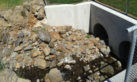
New drainage installment now needs removal of rock close to drain mouth moved further back up walnut stream to prevent future blockages
Roading/Streets, 1 Nov 2017
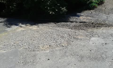
Build up of shingle, causing drain blockage, and gouging down walnut Avenue walkway, making it unsuitable for prams and wheel chair access
Elsewhere on Rue Noyer
- 9 Rue Noyer, 4 reports
- 11 Rue Noyer, 3 reports
- 7 Rue Noyer, 1 report
The civic layer
This ground votes in Banks Peninsula ward, the Banks Peninsula community board is its local layer. Ward lines don’t always follow suburb lines; this one is measured at the pin, not the suburb’s centre. The whole roll is at /wards.
Rue Noyer, the whole record → · Everything about Akaroa → · What stood on this ground → · On the map → · From the air, RetroLens holds the Crown’s aerials back to 1936; search the address there →
Questions, answered briefly
4 council reports on record since November 2017, most often wastewater/stormwater (1), street light outage (1), rubbish and bins - general (1).
Akaroa, Christchurch, on Rue Noyer.
Nothing on the heritage register at this exact spot, the record around this ground →
Stanley Park, 89 m to its edge, 7 ha.