19 Aubrey Street South
11 council reports since April 2022, 4 carrying a photograph. The most-reported address on Aubrey Street South.
The green nearby
- Garden Of Tane, you are in it · Botanic · 6 ha · playground, 7 pieces
- Hempleman Beach Reserve, 255 m to the edge
- Britomart Reserve, 329 m to the edge
- Hutchenson Reserve, 350 m to the edge · 1 ha
- Kowhai Grove Esplanade Reserve, 413 m to the edge
Parks within half a kilometre, measured to the boundary, the council’s open data. The whole roll is at /parks.
The civic shelf nearby
- Akaroa Anglican And Dissenters Cemetery, 147 m away · Cemetery
- Akaroa Catholic Cemetery, 168 m away · Cemetery
- Akaroa Library, 423 m away · Library
Libraries, halls and the rest within half a kilometre, the council’s open data.
On the doorstep
- Akaroa Health Centre, 190 m away · Business
- Akaroa Lighthouse, 208 m away · Attractions
- Oinako Lodge, 214 m away · B&Bs
- Akaroa Yacht Club, 230 m away · Clubs
Businesses within four hundred metres, measured at the pin, OpenStreetMap and the council directories.
The named ground
Named water within 500 m of this address, measured to the line or the edge; Named places within 1.5 km of this address; the council’s own structure register, bridges, boardwalks and steps standing nearby, the open map’s record.
The remembered names nearby
- Wollemi Pine / [several Lines ], 64 m away ·
WOLLEMI PINE / [several lines illegible]
· 1899 - Garden of Tane plaque, 78 m away ·
[plaque at base of tree; text largely illegible] / IN MEMORY OF / [illegible]
· 1899 - Nor’West Drive / [dedication Text ] / 29th October 2011, 79 m away ·
NOR’WEST DRIVE / [dedication text illegible] / 29th OCTOBER 2011
· 1899
Inscribed plaques within two hundred and fifty metres, the register’s pins, not surveyed spots. The whole roll is at /plaques.
What gets reported here
Photographed here 4 on record


What’s on record
 Pavement - General, 12 Jul 2026
 someone has thrown the timber railing down to the beach. could be resued easily and fixed. (i couldnt get there to get it myself but someone
 Street Gutters / Storm Water, 26 Jul 2025
 Large culvert at bottom of Garden of Tane under Beach Road. Blocked and overflowed in last storm. Needs clearing out.
 Graffiti somewhere else, 10 May 2024
 Beach Rd, Akaroa, town sidevof yacht club - power pole
- Fallen Tree, 4 Oct 2023
- Fallen Tree, 4 Oct 2023
- Fallen Tree, 4 Oct 2023
- Roads - General, 30 Sept 2023
- Fallen Tree, 16 Jan 2023
- Roads - General, 20 Nov 2022
- Roads - General, 15 Nov 2022
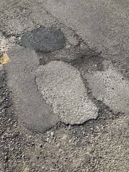 Roading/Streets, 15 Apr 2022
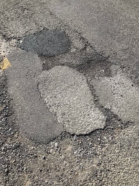
 Newly patched hole, next to other holes NOT filled, and less than 5mt from other unfilled holes.
Elsewhere on Aubrey Street South
- 17 Aubrey Street South, 3 reports
The civic layer
This ground votes in Banks Peninsula ward, the Banks Peninsula community board is its local layer. Ward lines don’t always follow suburb lines; this one is measured at the pin, not the suburb’s centre. The whole roll is at /wards.
Aubrey Street South, the whole record → · Everything about Akaroa → · What stood on this ground → · On the map → · From the air, RetroLens holds the Crown’s aerials back to 1936; search the address there →
Questions, answered briefly
11 council reports on record since April 2022, most often fallen tree (4), roads - general (3), street gutters / storm water (1).
Akaroa, Christchurch, on Aubrey Street South.
Nothing on the heritage register at this exact spot, the record around this ground →
Garden Of Tane, the address is inside it, 6 ha.