42 Selwyn Avenue
3 council reports since October 2019, 3 carrying a photograph. The street’s heaviest record is 2 Selwyn Avenue, 7 reports on file.
The green nearby
- Hutchenson Reserve, 145 m to the edge · 1 ha
- Stanley Park, 177 m to the edge · 7 ha
- Kowhai Grove Esplanade Reserve, 274 m to the edge
- Bercusson Reserve, 275 m to the edge
- Garden Of Tane, 416 m to the edge · Botanic · 6 ha · playground, 7 pieces
Parks within half a kilometre, measured to the boundary, the council’s open data. The whole roll is at /parks.
The civic shelf nearby
- Akaroa Library, 395 m away · Library
Libraries, halls and the rest within half a kilometre, the council’s open data.
On the doorstep
- Akaroa Cinema, 300 m away · Cinemas & theatres
- Akaroa Cinemas and Café, 356 m away · Cafés
- Cine Cafe Akaroa, 368 m away · Cinemas & theatres
- Akaroa Health Centre, 391 m away · Business
Businesses within four hundred metres, measured at the pin, OpenStreetMap and the council directories.
The named ground
Named water within 500 m of this address, measured to the line or the edge; Named places within 1.5 km of this address; the council’s own structure register, bridges, boardwalks and steps standing nearby, the open map’s record.
What gets reported here
Photographed here 3 on record


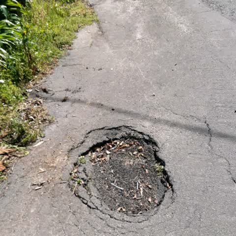
What’s on record
 Pavement - Damaged, 25 Feb 2026
 Following heavy rain last week a new hole has appeared by the sump on the footpath outside 40 and 42 Selwyn Avenue and the existing holes on
 Pavement - Damaged, 12 Sept 2025
 Pavement was being repaired because it has sink holes in it, but the job was never completed so now it needs doing all over again.
Roading/Streets, 1 Oct 2019
health and safety issues large hole in footpath
Elsewhere on Selwyn Avenue
- 2 Selwyn Avenue, 7 reports
- 11 Selwyn Avenue, 3 reports
- 8 Selwyn Avenue, 1 report
- 5–13 Selwyn Avenue, 1 report
- 53 Selwyn Avenue, 1 report
- 35 Selwyn Avenue, 1 report
- 25 Selwyn Avenue, 1 report
- 16B Selwyn Avenue, 1 report
The civic layer
This ground votes in Banks Peninsula ward, the Banks Peninsula community board is its local layer. Ward lines don’t always follow suburb lines; this one is measured at the pin, not the suburb’s centre. The whole roll is at /wards.
Selwyn Avenue, the whole record → · Everything about Akaroa → · What stood on this ground → · On the map → · From the air, RetroLens holds the Crown’s aerials back to 1936; search the address there →
Questions, answered briefly
3 council reports on record since October 2019, most often pavement - damaged (2), roading/streets (1).
Akaroa, Christchurch, on Selwyn Avenue.
Nothing on the heritage register at this exact spot, the record around this ground →
Hutchenson Reserve, 145 m to its edge, 1 ha.