120R Radcliffe Road, Belfast
16 reports on record since July 2024 · 16 with photographs. The street’s heaviest record is 1 Radcliffe Road — 27 reports on file. Indicative rating valuation and school zones, hazards, bin day and what stood here before.
What gets reported here
Photographed here 16 on record



Reported here
 Dumped Rubbish —
 Have just now seen the occupations dumping rubbish in Ratcliff Road. Didn't like their photo taken.
 Overgrown Vegetation —
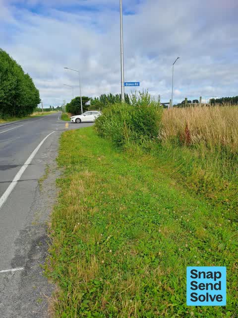
 Bushes overgrown on the corner of Ratcliff Road and Blake's Road when you come to the stop sign in Blake's you have to move over the yellow
 Dumped Rubbish —
 rubbish fly tipping
 Graffiti on a traffic light pole or cabinet, or wa —
 Under this bridge on the cycle way lots of graffiti present
 Dumped Rubbish —
 Dumped rubbish, mattress and couch, etc. thanks for keeping our city clean
 Graffiti on a sign, mural or public art —
 Someone had graffitied this road safety sign at the intersection of Blakes Road and Radcliffe Road. This is potentially dangerous. Thanks T
 Overgrown Vegetation —
 The over grown vegetation is blocking drivers sight for the cars moving from Blakes Rd into Radcliffe Rd, towards west. It gives the wrong i
 Damaged Road —
 Decent size pothole forming at the intersection of Blakes Rd & Radcliffe Rd. Also a trench line that has settled / sunken which is also pot
 Graffiti on a sign, mural or public art —
 Yellow arrow sign has black spray paint all over it. It's on Radcliffe Rd at the Blakes Rd intersection.
 Graffiti on a sign, mural or public art —
  Graffiti on a sign, mural or public art —
  Graffiti on a sign, mural or public art —
  Graffiti on a sign, mural or public art —
  Pothole —
 Pothole bas repair at intersection, keeps sinking, I almost fell off my motorcycle because of it. Also note the graffiti, previously snap
 Graffiti on a sign, mural or public art —
 Graffiti on road sign
 Vandalism - General —
 Beiing repaired or vandalism?
Also reported on Radcliffe Road
- 1 Radcliffe Road — 27 reports
- 303 Radcliffe Road — 24 reports
- 155 Radcliffe Road — 17 reports
- 140 Radcliffe Road — 15 reports
- 132 Radcliffe Road — 14 reports
- 45 Radcliffe Road — 10 reports
- 60 Radcliffe Road — 9 reports
- 135 Radcliffe Road — 9 reports
The street’s crash record
NZTA’s record names Radcliffe Road in 34 crashes that hurt somebody since 2006 — 11 seriously hurt, nobody killed.
The green nearby
- Styx River Conservation Reserve — 242 m to the edge · 11 ha
Parks within half a kilometre, measured to the boundary — the council’s open data.
The named ground
Named water within 500 m of this address, measured to the line or the edge — the open map’s record.
Renting nearby
new bonds in Belfast ran about $610 a week — $60 above the city median of $550 — the suburb page keeps the rent record →.
The civic layer
This ground votes in Harewood ward — the Fendalton-Waimairi-Harewood community board. Ward lines don’t always follow suburb lines; this one is measured at the pin, not the suburb’s centre.
What stood on this ground → · On the map → · From the air — the Crown’s aerials back to 1936; search the address on RetroLens →
Questions, answered briefly
16 council reports on record since July 2024 — most often graffiti on a sign, mural or public art (7), dumped rubbish (3), overgrown vegetation (2).
Belfast, Christchurch — on Radcliffe Road.
Nothing on the heritage register at this exact spot — the record around this ground →
Styx River Conservation Reserve — 242 m to its edge, 11 ha.