536 Wairakei Road, Burnside
24 reports on record since June 2015 · 13 with photographs. The most-reported address on Wairakei Road. Indicative rating valuation and school zones, hazards, bin day and what stood here before.
What gets reported here
- Water Leak — 4
- Overgrown Vegetation — 4
- Damaged Road — 3
- Water General — 2
- Dumped Rubbish — 2
- Damaged Street Sign — 2
Photographed here 13 on record



Reported here
- Damaged Road —
falling apart the roundabout
- Poles and Signage - General —
give way sign hanging out into the road
- Damaged Street Sign —
wairaki road street sign hanging down
- Graffiti on a road, footpath or bridge —
on the Island, (not the roundabout) is Tagging
 Pavement - General —
 Sign blocking footpath
 Road Signage —
 WAIRAKEI ROAD sign is off the pole at one end on the middle of the roundabout
 Damaged Street Sign —
 Street signs and roundabout damaged
 Damaged Road —
 Round about and signage damaged. Been like this for months Corner wairakei road and roydvale avenue
 Dumped Rubbish —
 Dumped wooden pallet
 Dumped Rubbish —
 Part of a car bonet or something
- Damaged Road —
The heavy concrete edge that encircles the roundabout has been smashed apart.
 Roads - General —
 This round about is falling apart badly.
 Water Leak —
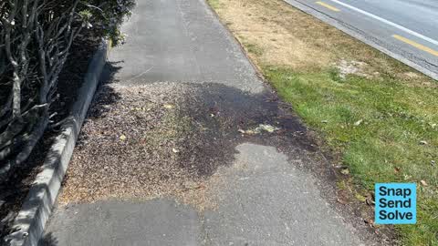
 Water has been running across footpath for quite a while.
 Water Leak —
 Hello - there has been a leak here for past 3+ months flooding the footpath - lots of gunk/algae buildup on the footpath as a result.
 Water General —
 Looks like a leak under footpath for some time and possibly getting worse
 Water Leak —
 Water leak on pavement
 Water General —
 Water is bubbling up from the grass verge in front of farmlands
- Graffiti —
- Overgrown Vegetation —
- Overgrown Vegetation —
- Overgrown Vegetation —
- Overgrown Vegetation —
- Water Leak —
Roading/Streets —
Loose gravel on the road at this intersection makes it quite dangerous to go through in my bike, since I have to either stay left and risk l
Also reported on Wairakei Road
- 656 Wairakei Road — 22 reports
- 490 Wairakei Road — 13 reports
- 442 Wairakei Road — 11 reports
- 319 Wairakei Road — 8 reports
- 379 Wairakei Road — 7 reports
- 330 Wairakei Road — 7 reports
- 585E Wairakei Road — 6 reports
- 567 Wairakei Road — 5 reports
The street’s crash record
NZTA’s record names Wairakei Road in 89 crashes that hurt somebody since 2006 — 1 person killed, 25 seriously hurt.
The green nearby
- Nunweek Park — 93 m to the edge · Sports ground · 20 ha
- Roydvale Reserve — 211 m to the edge
- Wairakei Reserve — 298 m to the edge · 1 ha
- Becmead Walkway — 458 m to the edge
Parks within half a kilometre, measured to the boundary — the council’s open data.
On the doorstep
- Beva Computers — 31 m away · IT & software
- Garden City Accountants — 38 m away · Accountants
- Agtrac — 66 m away · IT & software
- Repco — 68 m away · Car parts
Businesses within four hundred metres, measured at the pin — OpenStreetMap and the council directories.
The bus nearby
The closest Metro stops, within four hundred and fifty metres.
The tracks through here
- Walk and bike track through Burnside — 7 m to the line · walk · bike
- Walk and bike track through Burnside — 20 m to the line · walk · bike
- Walk and bike track through Burnside — 253 m to the line · walk · bike
- Walk and bike track through Burnside — 493 m to the line · walk · bike
Tracks whose line passes within half a kilometre, measured to the line itself — the council’s open data.
Renting nearby
new bonds in Burnside ran about $641 a week — $91 above the city median of $550 — the suburb page keeps the rent record →.
The civic layer
This ground votes in Harewood ward — the Fendalton-Waimairi-Harewood community board. Ward lines don’t always follow suburb lines; this one is measured at the pin, not the suburb’s centre.
What stood on this ground → · On the map → · From the air — the Crown’s aerials back to 1936; search the address on RetroLens →
Questions, answered briefly
24 council reports on record since June 2015 — most often water leak (4), overgrown vegetation (4), damaged road (3).
Burnside, Christchurch — on Wairakei Road.
Nothing on the heritage register at this exact spot — the record around this ground →
Nunweek Park — 93 m to its edge, 20 ha.