51 Kingsford Street, Burwood
22 reports on record since November 2017 · 17 with photographs. The street’s heaviest record is 63 Kingsford Street — 53 reports on file. Indicative rating valuation and school zones, hazards, bin day and what stood here before.
What gets reported here
Photographed here 17 on record


Reported here
 Graffiti on a fence, building or structure —
graffiti on wooden fence
 Graffiti on a fence, building or structure —
 Graffiti on a fence, building or structure —
Graffiti on fence facing Kingsford st half way down section
 Graffiti on a fence, building or structure —
Graffiti on fence facing Kingsford st
 Graffiti on a cabinet, pole or railway asset —
 Graffiti on a fence, building or structure —
 Graffiti somewhere else —
Corner section red zone fence line has graffiti
 Graffiti —
 Graffiti —
Next to Orion substation
 Graffiti —
 Graffiti —
Fence right along med building
 Graffiti —
 Graffiti —
- Graffiti —
- Graffiti —
- Graffiti —
- Graffiti —
- Graffiti —
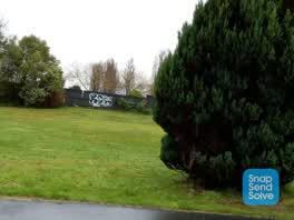 Graffiti —
There is fresh tagging on the Orion pump house next to this address.
Graffiti —
corner of Kingsford & new Brighton
Graffiti —
Also reported on Kingsford Street
- 63 Kingsford Street — 53 reports
- 67 Kingsford Street — 31 reports
- 61 Kingsford Street — 9 reports
- 70 Kingsford Street — 8 reports
- 124 Kingsford Street — 8 reports
- 66 Kingsford Street — 7 reports
- 95 Kingsford Street — 6 reports
- 118 Kingsford Street — 6 reports
The street’s crash record
NZTA’s record names Kingsford Street in 6 crashes that hurt somebody since 2006 — 0 seriously hurt, nobody killed.
The green nearby
- Burwood Park — 16 m to the edge · Sports ground · 14 ha
- Horseshoe Lake Reserve — 210 m to the edge · Regional · 33 ha
Parks within half a kilometre, measured to the boundary — the council’s open data.
On the doorstep
- Shirley Rugby Football Club — 209 m away · Clubs
- Burwood Park Tennis Club — 274 m away · Clubs
Businesses within four hundred metres, measured at the pin — OpenStreetMap and the council directories.
The bus nearby
- New Brighton Rd near Kingsford St — 63 m away · route 7, route 110
- Cresswell Ave and New Brighton Rd — 72 m away · route 7, route 110
The closest Metro stops, within four hundred and fifty metres.
The tracks through here
- Walk and bike track through Burwood — 16 m to the line · walk · bike
Tracks whose line passes within half a kilometre, measured to the line itself — the council’s open data.
The named ground
the council’s own structure register — bridges, boardwalks and steps standing nearby — the open map’s record.
Renting nearby
new bonds in Burwood ran about $600 a week — $50 above the city median of $550 — the suburb page keeps the rent record →.
The civic layer
This ground votes in Burwood ward — the Coastal-Burwood-Linwood community board. Ward lines don’t always follow suburb lines; this one is measured at the pin, not the suburb’s centre.
What stood on this ground → · On the map → · From the air — the Crown’s aerials back to 1936; search the address on RetroLens →
Questions, answered briefly
22 council reports on record since November 2017 — most often graffiti (15), graffiti on a fence, building or structure (5), graffiti somewhere else (1).
Burwood, Christchurch — on Kingsford Street.
Nothing on the heritage register at this exact spot — the record around this ground →
Burwood Park — 16 m to its edge, 14 ha.