
Public Toilet148 Lake Terrace Road
Still out of order! This is Un acceptable! Stop wasting our rates and do the basics
8,184 council reports since June 2015, the 15th busiest suburb in the city. 6,710 photographs on record. 6,360 people at the 2023 Census, 1,082 to the square kilometre across 5.9 km².
The record also holds about $600 a week to rent· 2023 Census snapshot· 6,710 photographs· 14 old photographs· 1 school· 18 parks· 4 places of worship· 25 tracks· 11 names on the map· 51.4% of the outline mapped liquefied· 10.2% of the outline in the red zone· graded mostly TC3 in 2011· the record drew water over 43% of the outline· the mapped tsunami reach covers 3% of the outline· the Ngāi Tahu schedule covers 52% of the outline· ecological sites over 28% of the outline· landscape schedules over 23% of the outline· high flood hazard over 27% of the outline· setback strips over 10% of the outline· 1% of the outline inside the plan’s density overlays· 3,224 SCIRT photographs filed on this ground· 18.2 km of cycleway crosses the outline· 10 remembered names on this ground· 16 drawn rules bind this ground· 10 parcels on the dangerous-work register· 438 parcels of made ground· 2 parcels with a cleanup on file· the 2019 model grades this ground mostly high· 61 council structures on the register· 36 recreation register records· 2,249 trees on the register· the plan’s word on this ground· 2% of the outline reserved· the plan’s exceptions touch 3% of the outline· 5 epicentres inside the outline· 219 injury crashes· 1,108 recorded victimisations· 46 bus stops· 24 businesses· the council’s fix times· 40 documents· 5 mentions on the wire
Link-outs to the source’s own live pages, chch.live does not copy their live values or source text.
New bonds here ran at about $600 a week in the April–June 2026 quarter, the middle half of them between $570 and $650, across 15 bonds lodged, up 4% on a year ago. That’s about $50 a week above the city’s own quarter median of $550. Tenancy Services counts these under the “Burwood” statistical area, close to this suburb’s outline, not exactly it.
Median and quartiles of weekly rents on new private bonds, by quarter. New bonds are fresh lodgements, not the whole rental stock; under five bonds the rent is withheld, and counts are randomly rounded. Source: Tenancy Services rental bond data: provisional while the bond system migrates.
The ground: 10% of the outline went into the residential red zone; the February 2011 survey drew liquefaction over 51% of it, the rest of the watch is drawn further down.
Day to day it holds 1 school, 18 parks, 4 places of worship, 25 tracks and 46 bus stops, each is counted further down.
Lately the record’s mostly graffiti & vandalism, 909 reports in the year to 12 October 2026, the newest 11 October 2026.
One for the quiz, Its busiest day on record was 30 October 2023, 59 reports in a single day.
About 3,564 people and 1,329 occupied private households in the “Burwood South” statistical area, grouped from 22 SA1 areas. This exact statistical-area match is close to this suburb’s outline, not exactly it.
Ethnicity is a multiple-response measure, so those percentages are not meant to add to 100%.
Stats NZ’s 2023 Census uses fixed random rounding to base 3. Unavailable or confidential cells are left out, not treated as zero. individuals · households · geography · CC BY 4.0.
Burwood is a north-eastern suburb of Christchurch, New Zealand. The suburb is mostly a residential area and is centred on Burwood Hospital, Travis Wetland Nature Heritage Park and Bottle Lake Forest.
Placed by the record’s locality join or the name in its own title, a lead, not a claim each frame stood here.
Still out of order! This is Un acceptable! Stop wasting our rates and do the basics

this expensive bespoke design toilet block is still closed after many months. Not good considering what the building would have cost!!! Massively over…

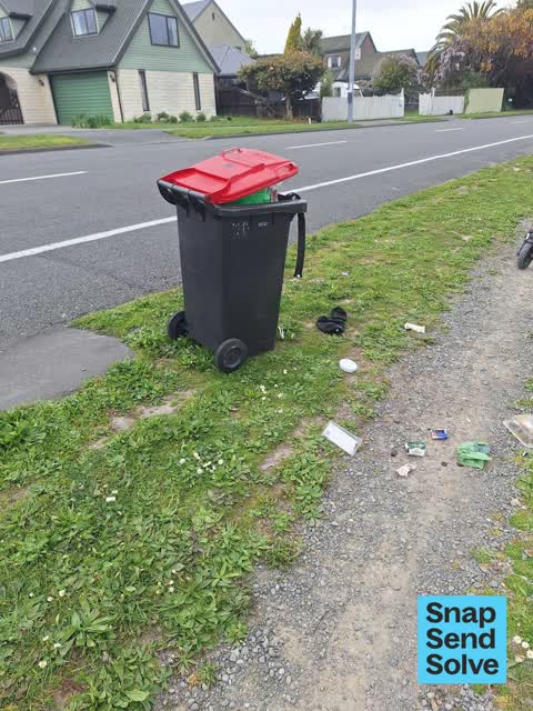
dumped red bin full of rubbish, rubbish over the ground also. bin number 4007423

Mowing and spotted irrigation sprinkler in front of me broken at Burwood park .


Hi there, Since we moved in, the berm outside our property has been uneven and rusted, as a result of the development of surrounding sections. We've only…


can you please come and fix the pathway, its breaking up. nga mihi


the people that are living here have left lights on 24 hours a day it's like five cats starving property is unkept and no one is seeing the lady around for a…
The median council work order pinned in Burwood took 3 days to resolve, about the city-wide median (3 days). The slowest tenth waited 3 months or longer. 256 tickets are open here now, the oldest was filed 18 December 2019.
Work orders, not the resident reports above, the council’s MyCouncilTicket stream, and one job can appear in both. A median counts only finished jobs; open ones are named as open, never averaged in. The ticket roll · the whole city’s fix times.
One sensitive site stands here, Waitākiri Primary School, and the Local Alcohol Policy restricts new off-licences within 200 m of it.
The council’s bylaw zones and the Local Alcohol Policy’s buffer list, read from the Regulatory open-data service. A ban rules drinking in public places; it says nothing about whether a premises may sell, that is the licence register’s job.
 Waitākiri Primary SchoolContributing · decile 8 · EQI 452
Zoned for Christchurch Adventist School · Mairehau High School · Marian College · Middleton Grange School · St Francis of Assisi Catholic School · Te Puna Wai o Waipapa - Hagley College · and 10 more zones, the drawn zone is indicative; the Ministry’s written scheme is the legal boundary.
Decile and EQI describe the community a school draws from, not how well it teaches.
The first eight of 18, Parks and reserves in the council’s open data, a park lands in the suburb its centre falls inside. The whole roll is at /parks.
Places of worship in the open map’s record, one lands in the suburb its building stands in. The whole roll is at /worship.
The first eight of 25, Tracks in the council’s open data, a line belongs to every suburb it passes through. The whole network is at /tracks.
The February 2011 survey drew mapped ground failure over 51.4% of this outline, about 302 hectares. A patch is a footprint, not a finding about an address; the count for the whole city is at /liquefaction.
The Crown’s 2011 classification drew 10.2% of this outline, about 60 hectares inside the residential red zone. A mapped area files under the suburb its middle sits in, and a classification is the record of a decision, not a finding about an address; the whole line is drawn at /redzone.
The 2011 grading filed 31.1% of this outline, about 183 hectares, mostly TC3, with TC3 109 ha · TC2 74 ha. A graded area files under the suburb its middle sits in, and a category is a verdict for a patch of ground, not a finding about an address; the grades are drawn at /technical-categories.
The flood record drew water over 43.2% of this outline, about 254 hectares, across 2 named events. A patch is one event’s observation, not a live hazard finding; the whole record is drawn at /floods.
The mapped tsunami extent covers 3% of this outline, about 16 hectares. The sea’s modelled reach, not a prediction, the plan’s inundation line, not the evacuation zones; the share is read from a sampled join. The whole extent is drawn at /tsunami.
10 parcels inside this outline sit on the hazardous-activities register, mostly chemical manufacture, application and bulk storage, cemeteries and waste recycling, treatment and disposal, vehicle refuelling, service and repair, 3 still doing the work. A listing records the work, not a soil test; the whole register is drawn at /hazards.
The files record 438 parcels of made or characterised ground inside this outline, about 150 hectares, mostly sand, topsoil, peat, 7 carry fill the file can’t vouch for. A record is the file’s word on what was laid, not a fresh survey; the whole layer is drawn at /fill.
2 parcels inside this outline carry a cleanup on the file. A cleanup on the file is the register’s word, not a clearance; the whole register is drawn at /remediated.
The 2019 liquefaction study put 48% of this outline in the high class, and 9 assessed areas here carry the free-face flag for possible lateral spreading. A class is the model’s verdict on a patch of ground, not a finding about an address; the whole study is drawn at /vulnerability.
The council’s structure register stands 61 assets on this ground, 22 boardwalks, 11 bridges, 9 sets of steps, 6 ramps, sited at Horseshoe Lake Reserve, Travis Wetland, Burwood Park, Anzac Drive Reserve. The register’s site names are its own labels for the ground an asset stands in; the layer is drawn at the map.
The recreation register keeps 36 records inside this outline, bookable surfaces for 8 tennis, 6 rugby, 5 cricket, 4 football, plus a marked dog exercise area and 9 pieces of dog-agility gear. Seasons and surfaces are the register’s record, not this week’s draw; the layer is drawn at the map.
The register counts 2,249 living trees inside this outline, 72 veterans among them, 83 carrying a protection, mostly Manna Ash, Ribbonwood, Yoshino Cherry. The file remembers 1,404 trees felled here. A tree record is the register’s word on what stands or stood; the whole canopy is drawn at /trees.
The plan files 29% of this outline under Residential Suburban, 32% residential, the rest mostly Specific Purpose (Otakaro Avon River Corridor) 29%, Open Space Natural 20%. A zone is a permission, not a description, the mix is read from a sampled join of the plan’s polygons; the whole district is drawn at /zones.
The plan reserves about 12 hectares of this outline, 2%, under 3 designations, mostly movement. A designation is a claim on the ground, not a build date, the mix is read from a sampled join; the whole register is drawn at /designations.
The plan’s exceptions touch 3% of this outline, 1 qualifying matter, mostly infrastructure. A matter narrows how the density rule applies, it does not forbid; the mix is read from a sampled join, and the cultural-significance areas are the plan’s own unnamed ones. The whole register is drawn at /matters.
The plan’s schedule of sites significant to Ngāi Tahu covers 52% of this outline, about 304 hectares, ngā tūranga tūpuna. Shares read from a sampled join; a recognition overlay, not a catalogue. The whole schedule is drawn at /cultural.
The plan’s ecological schedules cover 28% of this outline, about 164 hectares across 3 scheduled sites, all protected under Schedule A. Shares read from a sampled join; a recognition overlay, not a survey. The whole ledger is drawn at /ecology.
The plan’s landscape schedules cover 23% of this outline, about 136 hectares across 2 scheduled areas, 19% of it outstanding, the plan’s strongest landscape standing. Shares read from a sampled join; a protection overlay, not a ranking of views. The kept view is drawn at /landscape.
The plan’s flood map draws 27% of this outline inside high flood hazard ground, about 160 hectares across 6 mapped areas. The broader flood-management watch covers 65% of it, Avon River. Shares read from a sampled join; a model’s map, not a promise. The waiting water is drawn at /flood-hazard.
The plan’s water-margin layers cross this outline, 81 classified reaches, the plan calling Angela Stream and Horseshoe Lake Outlet by name, 10% of it inside the setback strips, the widest holding 30 m off the bank, and an esplanade line holds a public edge here. The margin is the plan’s drawing, not a survey of the bank; the reaches, strips and held edges are mapped at /water-margin.
The plan’s allowed shape holds this outline, 1% of it inside the residential overlays, the densest standing Suburban. The shape is the plan’s permission, not a survey of what stands; the allowed shape is drawn at /density.
The rebuild’s cameras filed 3,224 photographs on this ground, 2001–2016, stormwater work mostly. Each frame is a receipt the dig left behind, a work log, not a survey of what stands now; the whole record is drawn at /rebuild.
The pedal network threads this ground, 18.2 km of cycleway crosses the outline. A segment counts under every suburb its path enters; the whole network is drawn at /cycleways.
The remembered names stand on this ground, 10 inscribed plaques, Donnell Sports Park, Brooker Monument, Amelia Rogers Reserve among the grounds. The plaque is the register’s pin, not a surveyed spot; the whole roll is kept at /plaques.
The rulebook binds this ground, 16 drawn instruments, 10 of them dog rules, 1 alcohol ban, 5 bottle-store buffers; the outline sits inside the takiwā of Te Ngai Tuahuriri Runanga. The bylaw is the instrument, this the map of it, the whole rulebook is drawn at /rules.
GeoNet’s catalogue puts 5 magnitude-3+ epicentres inside this outline since the sequence opened, the biggest a M3.3 in 2010. An epicentre is where the instruments placed the break, not a measure of the shaking here; the whole catalogue is counted at /sequence, the live record is /quakes, and the story in plain language is the earthquakes explainer.
The named waterways, bays, headlands, monuments, summits and old sites OpenStreetMap puts inside this outline, a pin is the mapper’s own; a waterway belongs to every suburb it crosses. Every roll, counted: /geography.
219 crashes that hurt somebody on record inside Burwood's outline, 1 person killed, 44 seriously hurt.
The corner that keeps appearing: New Brighton Road at Bassett Street, 10 injury crashes, 1 fatal.
1,108 victimisations on the Police record inside Burwood’s outline, September 2022–August 2026, mostly theft, about 78 a year per 1,000 residents. Up 18% on the year before. Reported is not all, how much never reaches the record depends on the offence.
46 Metro stops inside Burwood's outline, in ECan’s stop record, served by route 7, route 60, route 135, route 110, route 44.
24 premises in Burwood across 12 kinds, from OpenStreetMap, the council’s licensed-premises register and its 2024 Find Christchurch directory. Each kind below opens at this suburb’s shelf.
Among them, the ones the record says most about:
What the archive’s sources say about Burwood, titled for it, turned up by a search for one of its places, or carrying its name in the text. These are leads and citations: the originals live at the provider, linked from each row.
…ke mararoa downs mr davidmkellar waikaka plains mr cuthbert cowan okateru mr john mgregor burwood and mr robert aitken waiau we have received the evangelist for the month of march it is of a strongly…Otago Witness · Papers Past · National Library of New Zealand · · text held
…rk is still briskly going on in the m arar oa and te anau districts with the exception of burwood shearing has barely commenced the clip generally is reported to be turning out admirably owing no doub…Otago Witness · Papers Past · National Library of New Zealand · · text held
…th full particulars will appear shortly the war is still waged against the rabbits on the burwood station north of invercargill large numbers of the young were drowned upon the melting of the snow lat…Otago Witness · Papers Past · National Library of New Zealand · · text held
…the late p e cadell formerly of maitland and eldest daughter of the lale john carfrae esq burwood aged 56…Nelson Evening Mail · Papers Past · National Library of New Zealand · · text held
…holidays j one month only 1 j ready money richards and co r dee street oc3o a t ost from burwood station a bay horse branded with a club and c figure 2 upside down on near shoulder star t on forehead…Southland Times · Papers Past · National Library of New Zealand · · text held
…irl beat little queen sam slick beat lockwood sefton beat menator loco beat shooting star burwood beat encore lnna beat hinemoa don carlos beat alba…Bruce Herald · Papers Past · National Library of New Zealand · · text held
…eston t burnett g horan t nicolson h poison tw adams a armstead jas maher jas warren robt burwood t haynes w n davidson a mißcalef and four names un fiiiown ff tho whole of the survivors together with…Otago Daily Times · Papers Past · National Library of New Zealand · · text held
Reproduction of Painting of Bottle Lake by John Gibb. All Saints Church, Burwood collection…All Saints Church, Burwood collection · Canterbury Stories · Christchurch City Libraries ·
…ing fatal accident occurred yesterday afternoon to a married woman named gibson wife of a burwood miner while crossing the burwood coal company line near newcastle a locomotive knocked her down passin…Otago Witness · Papers Past · National Library of New Zealand · · text held
…r apply to vincent and co 0545 wanted tenders for 100 yards screened shingle delivered at burwood horse shoe lake tenders np to feb 10 george king and co 224 cashel street 9683 wanted known that j pul…Star · Papers Past · National Library of New Zealand · · text held
The rest are a search away, the whole shelf, for the name →
Compare Burwood with Avondale · Shirley · Dallington · Aranui · Wainoni · Parklands, same record, side by side.
Burwood is a north-eastern suburb of Christchurch, New Zealand. The public record holds 8,184 council reports for it, the first filed in June 2015.
6,360 people at the 2023 Census, 1,082 per square kilometre across 5.9 km².
About 3,564 people and 1,329 occupied private households: grouped from Stats NZ SA1 areas through this site’s suburb join. Indicative, not a LIM.
8,184 reports on record, most often graffiti & vandalism (2,494), rubbish & dumping (2,473), trees & parks (1,177). 909 of them in the year to 12 October 2026.
219 injury crashes on the police record inside the suburb’s outline, 1 person killed, 44 seriously hurt. The suburb’s crashes, mapped →
GeoNet’s catalogue puts 5 magnitude-3+ epicentres inside the suburb’s mapped outline since the September 2010 mainshock, the biggest a M3.3 in 2010. An epicentre is where the instruments placed the break, not a measure of the shaking felt here. The whole sequence, counted → · The story, in plain language →
Every suburb in Christchurch → · Its decade, charted → · the whole A–Z →
Work orders, not the resident reports above, the council’s MyCouncilTicket stream, and one job can appear in both. A median counts only finished jobs; open ones are named as open, never averaged in. The ticket roll · the whole city’s fix times.
The council’s bylaw zones and the Local Alcohol Policy’s buffer list, read from the Regulatory open-data service. A ban rules drinking in public places; it says nothing about whether a premises may sell, that is the licence register’s job.
Ministry of Education directory, the final decile and the current Equity Index describe the community a school draws from, not how well it teaches. Zones are indicative; the written enrolment scheme rules.
Parks and reserves in the council’s open data, the park lands in the suburb its centre falls inside; one that straddles the line keeps its own address.
Libraries, halls, cemeteries and the rest in the council’s open data, a facility lands in the suburb its point or centre falls inside.
Places of worship in the open map’s record, one lands in the suburb its building stands in. The whole roll is at /worship.
Marae in the region’s roll, a marae stands where it stands; the join names the suburb the roll files it under. The whole roll is at /maraes.
Walking, biking, horse and off-road tracks in the council’s open data, a line belongs to every suburb it passes through.
OpenStreetMap’s own record, inside this outline, a pin is the mapper’s; a waterway belongs to every suburb it crosses. Every roll, counted: /geography.
Heritage places the council’s district plan or Heritage New Zealand list inside this suburb, each with what is known about it and the document it is known from.
The register’s era records for places in this suburb, what stood on the ground, and when.
Each of these is a decade of reports, the heritage places on the register, what is known about them, and the documents behind it, everything the archive holds about the part of the city it names.