Opawa Tennis
Opawa Tennis is a sports centre in Opawa, Christchurch.
Is this your business? Send hours, menu or photos, free and this page updates. Its site read as gone: chch.live’s maker builds simple sites for Christchurch businesses. Know its hours? Add them on OpenStreetMap, the page picks them up overnight.
Checked 19 Oct 2026
Tennis club in Opawa, established 1907: read from the public record
Opawa
Reviews
Getting there
The map loads only when you ask for it.
Straight-line distances from the pin, not walking routes.
Nearby
Environment Canterbury’s Canterbury Maps Parks layer, refreshed 2026-10-10. Distances are straight-line from the business pin, not walking routes.
The nearest other sports centres
More nearby sports centres 5
Also in Opawa
More businesses in Opawa 7
What the record holds 5 sourced facts
What the record holds
| Fact | What the source says | Source |
|---|---|---|
| Kind | Sports centres | OpenStreetMap |
| Website | sporty.co.nz · unreachable when last read 27 Sept 2026 | OpenStreetMap |
| Also known as | Opawa Tennis Club | OpenStreetMap |
| Opened | 1907 | OpenStreetMap |
| Last checked by a mapper | 1 Aug 2024 | OpenStreetMap |
The ground it stands on
| Fact | What the source says | Source |
|---|---|---|
| District Plan zone | Residential Suburban | District Plan |
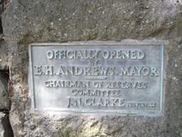 Officially Opened by E. H. Andrews, Mayor Chairman
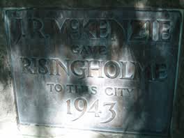 J. R. McKenzie Gave Risingholme to This City 1943
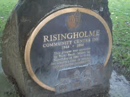 Risingholme Community Centre Inc. 1944 — 1994 This Plaque
The reports nearby
402 council reports pinned within 250 m of the premises, most often Trees & parks and Graffiti & vandalism, 326 with a photograph. A pin is where a reporter stood, not a claim about the place itself.
 Water Leak
 Graffiti on a road, footpath or bridge
 Water Leak
 Overgrown Vegetation
 Graffiti on a bus stop or public toilet
 Bus Shelter Issue
 Dumped Rubbish
 Playground Equipment
 Graffiti on a fence, building or structure
 Trees - General
 Park - General Request
Questions, answered briefly
Read answers 7
A sports centre in Opawa, Christchurch.
Somewhere in Opawa, the record holds no street address. On the map →
On OpenStreetMap, last checked by a mapper 1 Aug 2024.
its website.
Opawa Bowling Club (366 m), Whittington Avenue Sports Field (490 m), Waltham Summer Pool (748 m), every one in the city.
1 other premises within a short walk, nearest Opawa Bowling Club (366 m); the St Martins Rd near Ensors Rd bus stop is 170 m away: route Oa; a cycle lane passes within 150 m; nearest park: Risingholme Park (152 m).
The record behind this
This page is the union of what these public sources say, each fact above names the one it came from. A listing is a lead, not a promise the business still trades:
Sources: OpenStreetMap · Christchurch District Plan layers · Environment Canterbury’s Metro stop record · Christchurch City Council’s cycleway layer
Read source notes 4
- OpenStreetMap, named premises drawn and kept current by its contributors (ODbL)
- Christchurch District Plan layers, zones, commercial centres and scheduled heritage items, from the council’s open data (CC BY 4.0)
- Environment Canterbury’s Metro stop record, distances measured here from the pin
- Christchurch City Council’s cycleway layer, lanes, separated paths and the named Major Cycle Routes (CC BY 4.0)
Map data © OpenStreetMap contributors (ODbL); council and ECan data under CC BY 4.0; Wikidata CC0. Something wrong? Fix it on OpenStreetMap or tell us. The whole directory lives at /businesses. This page as markdown: /business/opawa-tennis-opawa.md.