22 Cholmondeley Avenue, Opawa
37 reports on record since August 2019 · 30 with photographs. The most-reported address on Cholmondeley Avenue. Indicative rating valuation and school zones, hazards, bin day and what stood here before.
What gets reported here
- Parks — 8
- Fallen Tree — 7
- Overgrown Vegetation — 4
- Graffiti — 4
- Park - General Request — 3
- Water Leak — 2
Photographed here 30 on record


Reported here
 Overgrown Vegetation —
 We have a rat getting into the Homestead building. Pest Control advised that is evident they are getting in using the tree overhanging the
 Graffiti on a bus stop or public toilet —
 Door handles gone
 Park - General Request —
 It hasn’t rained for ages and plants at ridingjome that are new are going to die if the aren’t watered. Any rain never eventuates
 Water Leak —
 Water leak on the footpath next to the fence at Risingholme Park.
 Overgrown Vegetation —
 Weeds and overgrown vegetation in beautiful Risingholme Park . It must be a year since all the edge bedding gardens have been weeded . Dead
 Flooding —
 Jackson’s Creek water in flood covering over openings to culvert’s at 19 Cholmondeley Ave &Risingholme Park. 22CholmondeleyAve.Of concern..
 Flooding —
 Blocked Culvert RisingHolme park off Cholmondeley ave, causing Jackson’s creek flooding.
 General Request —
 Blocked waterway and culvert in Jackson’s Creek by Risingholm, causing flooding in creek.
 Overgrown Vegetation —
 A tree in Risingholme park needs to be trim as it overhanging the driveway. To avoid this trucks are driving on the grass damaging it.
 Facility - General Request —
 Due to the growth of the trees this walkway has become very dark at night making it unsafe for the community who use it. Some type of light
 Fallen Tree —
 This tree is about to fall down as the dirt and roots around it have become loose
 Fallen Tree —
 A branch from a large tree next to the hall has broken and is hanging down. This will need to be removed before it breaks completely and co
 Sewer - Leak / Blockage —
 Toilet not flushing properly in left side block
 Fallen Tree —
 Large branch has fallen from one of the heritage trees in the Risingholme park, Luckily no one was near the branch when it fell with a large
 Water Leak —
 At the public toilets in Risingholme park, someone has stolen the pile from the wall to the handbasin and water is gushing out of the pipe i
 Fallen Tree —
 Fallen tree at risingholme over pathway and broken commemorative tree aswell
 Fallen Tree —
  Fallen Tree —
 Big tree by public toilets on Risingholme park has fallen over 2 paths and blocked them, also fallen on and broken the kowhai tree
 Public Toilet —
 Basin waste no longer connected to outflow . Urgent due to public hygiene and safety.
 Overgrown Vegetation —
 Lots of deadly nightshade
- Graffiti —
- Park - General Request —
- Public Toilet —
- Fallen Tree —
- Park - General Request —
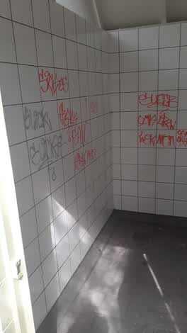 Graffiti —
 Risingholme Comm Centre Toilets
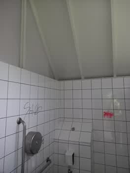 Graffiti —
 Risingholme toilets
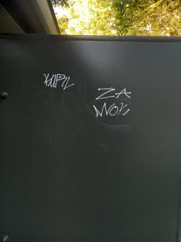 Graffiti —
 Left toilet risingholme park
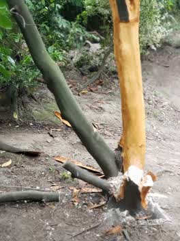 Parks —
 These punks have a habit of this type of thing, usually on Saturday afternoons. This latest disgrace by the water fountain. There's like thr
- Street Light Outage —
I can't take a photo as it's too dark, but there is a path light at Risingholme that isn't working, which makes it very unsafe when leaving
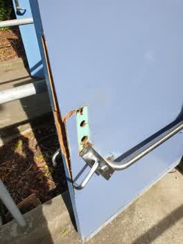 Parks —
 damaged toilet door lock
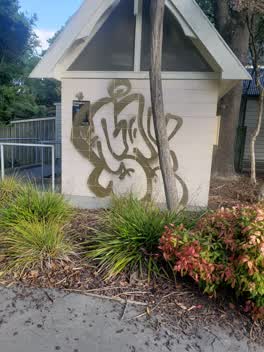 Parks —
 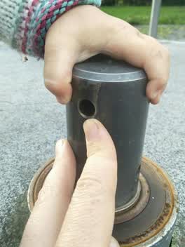 Parks —
 This roundabout has a it in the middle that stays stationary while the rest is turning. If a curious child were to put their finger in one o
- Parks —
Human excrement on walking path next to the locked toilets.
Parks —
public toilet rear of Risinghome house. Hand basin drain pipe is disconnected and draining onto the floor.
Parks —
Broken sink in park toilet
Parks —
Merry go round entrapment, uneven equipment or surface caught and pulled child's leg under.
Also reported on Cholmondeley Avenue
- 1 Cholmondeley Avenue — 17 reports
- 26A Cholmondeley Avenue — 9 reports
- 20 Cholmondeley Avenue — 8 reports
- 40 Cholmondeley Avenue — 4 reports
- 30 Cholmondeley Avenue — 4 reports
- 34 Cholmondeley Avenue — 3 reports
- 5 Cholmondeley Avenue — 2 reports
- 48 Cholmondeley Avenue — 2 reports
The street’s crash record
NZTA’s record names Cholmondeley Avenue in 1 crash that hurt somebody since 2006 — 0 seriously hurt, nobody killed.
The green nearby
- Risingholme Park — you are in it · Botanic · 2 ha
- Acorn Reserve — 333 m to the edge
- Fifield Reserve — 382 m to the edge
- Heathcote Riverbank Reserve — 476 m to the edge
Parks within half a kilometre, measured to the boundary — the council’s open data.
On the doorstep
- Opawa Tennis — 137 m away · Sports centres
- Opawa Bakery & Cafe — 292 m away · Cafés
- Kowhai Vet — 294 m away · Vets
- Love Me Again Vintage — 299 m away · Clothing
Businesses within four hundred metres, measured at the pin — OpenStreetMap and the council directories.
The bus nearby
- Opawa Rd near Cholmondeley Ave — 286 m away · route 8
- St Martins Rd near Ensors Rd — 288 m away · the Orbiter (clockwise)
The closest Metro stops, within four hundred and fifty metres.
The tracks through here
- Walk and bike track through Opawa — 139 m to the line · walk · bike
- Walk and bike track through Opawa — 140 m to the line · walk · bike
- Walk and bike track through Opawa — 170 m to the line · walk · bike
- Walk and bike track through Opawa — 179 m to the line · walk · bike
- Walk and bike track through Opawa — 288 m to the line · walk · bike
Tracks whose line passes within half a kilometre, measured to the line itself — the council’s open data.
The named ground
Named water within 500 m of this address, measured to the line or the edge; the council’s own structure register — bridges, boardwalks and steps standing nearby — the open map’s record.
The remembered names nearby
- Planted by the Children of Risingholme Playcentre — 26 m away ·
PLANTED BY THE CHILDREN OF RISINGHOLME PLAYCENTRE FOR INTERNATIONAL YEAR OF THE CHILD 1979
· 2009 - Risingholme Community Centre Inc. 1944 — 1994 This Plaque — 58 m away ·
RISINGHOLME COMMUNITY CENTRE INC. 1944 — 1994 This plaque was unveiled by Vicki Buck, Mayo
· 2009 - Officially Opened by E. H. Andrews, Mayor Chairman — 72 m away ·
OFFICIALLY OPENED BY E. H. ANDREWS, MAYOR CHAIRMAN OF RESERVES COMMITTEE J. N. CLARKE NOV
· 2009
Inscribed plaques within two hundred and fifty metres — the register’s pins, not surveyed spots. The whole roll is at /plaques.
Renting nearby
new bonds in Opawa ran about $555 a week — about the city median — the suburb page keeps the rent record →.
What was here — Former Dwelling and Setting, Risingholme
on this spot · 22 Cholmondeley Avenue · located to ±17 m · the place’s own record →
On the register. Nothing researched here yet.
What was here — 9 Ford Road
118 m away · 9 Ford Road · located to ±14 m · the place’s own record →
On the register. Nothing researched here yet.
The civic layer
This ground votes in Heathcote ward — the Spreydon-Cashmere-Heathcote community board. Ward lines don’t always follow suburb lines; this one is measured at the pin, not the suburb’s centre.
What stood on this ground → · On the map → · From the air — the Crown’s aerials back to 1936; search the address on RetroLens →
Questions, answered briefly
37 council reports on record since August 2019 — most often parks (8), fallen tree (7), overgrown vegetation (4).
Opawa, Christchurch — on Cholmondeley Avenue.
The heritage register names 2 places at or beside it — Former Dwelling and Setting, Risingholme, 9 Ford Road.
Risingholme Park — the address is inside it, 2 ha.