Roads - General445 Governors Bay Road, Lyttelton
those is a turn around used my many gov bay residents so you can access and exit your driveway safely. it is difficult to see oncoming traffic before pulling…
164 council reports since October 2015, the 98th busiest suburb in the city. 117 photographs on record.
The record also holds about $600 a week to rent· 2023 Census snapshot· 117 photographs· 2 old photographs· 2 heritage places· 40 documents· 4 mentions on the wire
Link-outs to the source’s own live pages, chch.live does not copy their live values or source text.
New bonds here ran at about $600 a week in the April–June 2026 quarter, the middle half of them between $473 and $640, across 24 bonds lodged, up 9% on a year ago. That’s about $50 a week above the city’s own quarter median of $550. Tenancy Services counts these under the Lyttelton area, which takes in this coast with its neighbours.
Median and quartiles of weekly rents on new private bonds, by quarter. New bonds are fresh lodgements, not the whole rental stock; under five bonds the rent is withheld, and counts are randomly rounded. Source: Tenancy Services rental bond data: provisional while the bond system migrates.
Lately the record’s mostly water & drains, 7 reports in the year to 12 October 2026, the newest 11 July 2026.
One for the quiz, Its busiest day on record was 22 July 2024, 4 reports in a single day.
About 3,117 people and 1,353 occupied private households in the “Lyttelton” statistical area, grouped from 19 SA1 areas. Nearby statistical areas stand in for this place, so this is a proxy rather than a count for the suburb boundary.
Ethnicity is a multiple-response measure, so those percentages are not meant to add to 100%.
Stats NZ’s 2023 Census uses fixed random rounding to base 3. Unavailable or confidential cells are left out, not treated as zero. individuals · households · geography · CC BY 4.0.
Placed by the record’s locality join or the name in its own title, a lead, not a claim each frame stood here.
those is a turn around used my many gov bay residents so you can access and exit your driveway safely. it is difficult to see oncoming traffic before pulling…

this dead tree sticks out onto the road forcing walkers to have to walk on the road and also gets a bit close with passing cars if there is another in the…
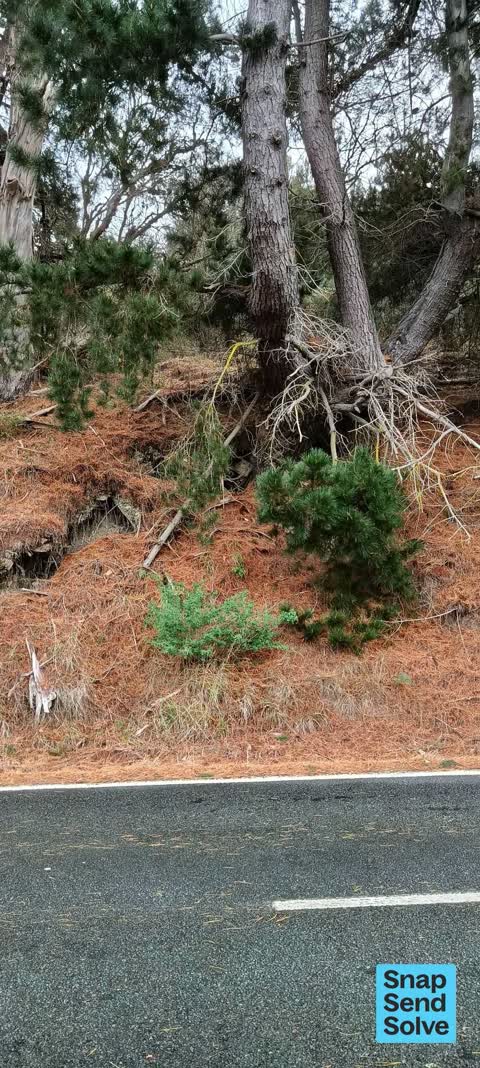
this one tree is learning out towards the road and the dirt around the base is washing away. two of these trees have already fallen across the road lately plus…
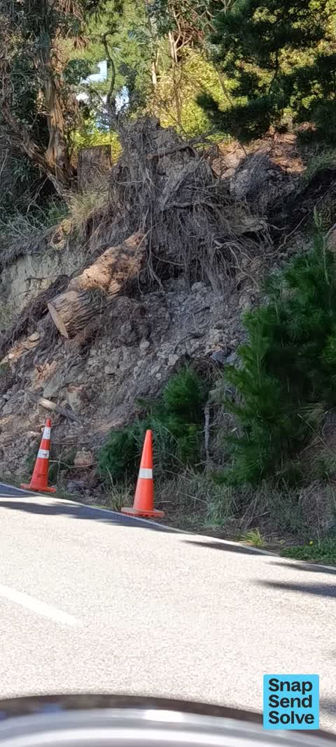
last rain storm, two wilding pines fell across the road. The stump left looks like it will fall to road in next rain storm and the other tree along further…

Blocked drain alongside road. Drain needs to be cleared out.
Stormwater runoff from Governors bay road (above the pensioner flats) continues to inundate private property. This has been an ongoing issue for several years…
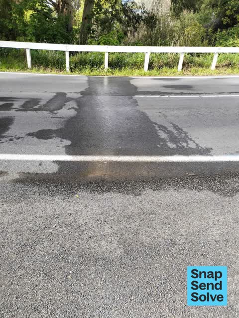
Water coming out of road been there 5 days . constant and appears to be getting bigger

bin over flowing and grass still not cut after my millionth SSS since jan. Grass at the back of reserve nit slip way. Also convolvulus everywhere, gardens just…

I've been reporting the same thing since feb, yet again they have poorly weedwacked near the ramp, churning up cabbage tree leaves which are now all over the…

probably the 4th sss I've sent now, nobody has done the back section since before Christmas, last time I complained they came and did the front section and…
No boundary is on record for Rapaki, the joins that count inside an outline (the crash tally, the ground layers, the area figures) stay unanswered rather than guessed.
What the archive’s sources say about Rapaki, titled for it, turned up by a search for one of its places, or carrying its name in the text. These are leads and citations: the originals live at the provider, linked from each row.
The rest are a search away, the whole shelf, for the name →
20 more documents came up in searches for Rapaki's places and have not been read yet, a lead is a search result, not a fact, until somebody reads it.
Compare Rapaki with Te Rapaki o Te Rakiwhakaputa · Cass Bay · Governors Bay · Corsair Bay · Lyttelton · Heathcote Valley, same record, side by side.
A suburb of Christchurch, New Zealand, the public record holds 164 council reports for it, the first filed in October 2015.
About 3,117 people and 1,353 occupied private households (nearby SA1s): grouped from Stats NZ SA1 areas through this site’s suburb join. Indicative, not a LIM.
164 reports on record, most often water & drains (37), graffiti & vandalism (34), roads & footpaths (33). 7 of them in the year to 12 October 2026.
The heritage register holds 2 places here, Bridge/Culvert and Setting, Governors Bay Road Bridge/Culvert and Setting. The written record goes back further: the shelf, for the name →
Every suburb in Christchurch → · Its decade, charted → · the whole A–Z →
Work orders, not the resident reports above, the council’s MyCouncilTicket stream, and one job can appear in both. A median counts only finished jobs; open ones are named as open, never averaged in. The ticket roll · the whole city’s fix times.
The council’s bylaw zones and the Local Alcohol Policy’s buffer list, read from the Regulatory open-data service. A ban rules drinking in public places; it says nothing about whether a premises may sell, that is the licence register’s job.
Ministry of Education directory, the final decile and the current Equity Index describe the community a school draws from, not how well it teaches. Zones are indicative; the written enrolment scheme rules.
Parks and reserves in the council’s open data, the park lands in the suburb its centre falls inside; one that straddles the line keeps its own address.
Libraries, halls, cemeteries and the rest in the council’s open data, a facility lands in the suburb its point or centre falls inside.
Places of worship in the open map’s record, one lands in the suburb its building stands in. The whole roll is at /worship.
Marae in the region’s roll, a marae stands where it stands; the join names the suburb the roll files it under. The whole roll is at /maraes.
Walking, biking, horse and off-road tracks in the council’s open data, a line belongs to every suburb it passes through.
OpenStreetMap’s own record, inside this outline, a pin is the mapper’s; a waterway belongs to every suburb it crosses. Every roll, counted: /geography.
Heritage places the council’s district plan or Heritage New Zealand list inside this suburb, each with what is known about it and the document it is known from.
The register’s era records for places in this suburb, what stood on the ground, and when.
Each of these is a decade of reports, the heritage places on the register, what is known about them, and the documents behind it, everything the archive holds about the part of the city it names.