107 Cashel Street
7 council reports since January 2018, 7 carrying a photograph. The street’s heaviest record is 210 Cashel Street, 53 reports on file.
On the register here
- Former Beaths Department Store (components), 201/690 Colombo Street (105m)
- Triangle Reserve and Setting, 291F High Street (126m)
- Triangle Reserve and Setting, 261F High Street (166m)
- Commercial Building and Setting, Former Chief Post Office, 1 Cathedral Square (172m)
- Public Trust Building, 152 Oxford Terrace (192m)
From the air, then
Sourced from Canterbury Maps and partners. LINZ, CC BY 3.0 NZ. Each frame is cut from Environment Canterbury’s historic imagery MapServer for that decade, only where the Footprints layer names a CC BY survey (NZAM-covered spots stay out). RetroLens holds more Crown aerials →
The green nearby
- City Mall, 91 m to the edge
- The Stewart Plaza, 109 m to the edge
- High Street Triangles, 154 m to the edge
- Bridge Of Remembrance, 173 m to the edge · Botanic
- Friendship Corner, 175 m to the edge · Botanic
Parks within half a kilometre, measured to the boundary, the council’s open data. The whole roll is at /parks.
The civic shelf nearby
- Triangle, 123 m away · Car park
- Re:start - Lichfield Street, 210 m away · Car park
- Turanga Library, 344 m away · Library
- Civic Offices, 345 m away · Council office
- Scales, 383 m away · Car park
Libraries, halls and the rest within half a kilometre, the council’s open data.
On the doorstep
- Spark, 8 m away · Phone shops
- Taking Shape, 10 m away · Business
- Unichem, 14 m away · Pharmacies
- 2degrees Store Cashel Mall, BNZ Centre, 16 m away · Phone shops
Businesses within four hundred metres, measured at the pin, OpenStreetMap and the council directories.
The bus nearby
- Bus Interchange (Intercity stop), 181 m away · route 3, route 8, route 80
- Hereford St near Colombo St, 195 m away · route 8
The closest Metro stops, within four hundred and fifty metres.
The tracks through here
- Walk and bike track through Christchurch Central City, 141 m to the line · walk · bike
- Walk and bike track through Christchurch Central City, 154 m to the line · walk · bike
- Walk and bike track through Christchurch Central City, 216 m to the line · walk · bike
- Walk and bike track through Christchurch Central City, 220 m to the line · walk · bike
- Walk and bike track through Christchurch Central City, 231 m to the line · walk · bike
Tracks whose line passes within half a kilometre, the council’s open data.
The named ground
Named water within 500 m of this address, measured to the line or the edge; Named places within 1.5 km of this address; the council’s own structure register, bridges, boardwalks and steps standing nearby, the open map’s record.
The remembered names nearby
- On This Site on the 16th Dec, 176 m away ·
ON THIS SITE ON THE 16TH DEC. 1867 THE FIRST PARADE OF E. BATTERY CHRISTCHURCH ARTILLERY V
· 2009 - The Battle for Crete / May 1941, 176 m away ·
THE BATTLE FOR CRETE / MAY 1941 / IN MEMORY OF THOSE WHO GAVE THEIR LIVES / AND THOSE WHO
· 2017 - City of Christchurch This Plaque Records the Completion, 179 m away ·
CITY OF CHRISTCHURCH THIS PLAQUE RECORDS THE COMPLETION OF MAJOR REFURBISHMENT OF THE BRID
· 2009
Inscribed plaques within two hundred and fifty metres, the register’s pins, not surveyed spots. The whole roll is at /plaques.
Renting nearby
new bonds in Christchurch Central City ran about $508 a week, $42 below the city median of $550, the suburb page keeps the rent record →.
What gets reported here
Photographed here 7 on record



What’s on record
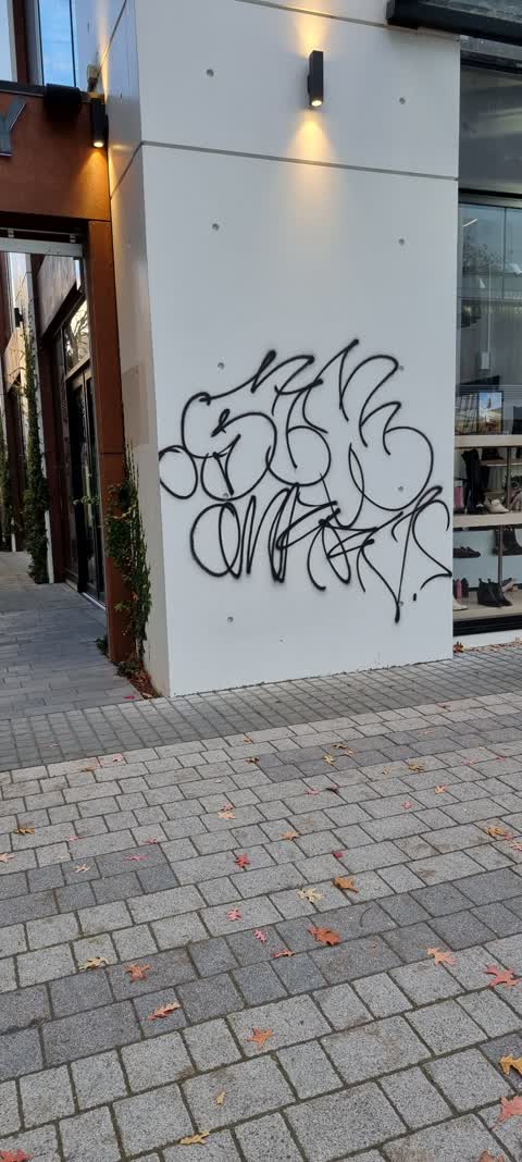
 Graffiti on a fence, building or structure, 14 Jul 2026
Graffiti on roller door
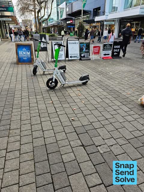
 Accessibility, 30 May 2026
Row of shop message boards creating a choke point. walk around them on the left having to wait as only 3 people can pass or walk around the
 Street Cleaning, 8 Dec 2025
Rubbish all down Cashel Street city Mall - looks terrible
 Graffiti on a fence, building or structure, 19 Oct 2024
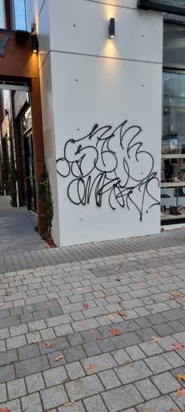 Graffiti, 1 May 2022
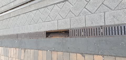
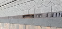 Roading/Streets, 7 Jan 2021
drain cover come off in multiple places. very dangerous for pedestrians, broken ankles etc...
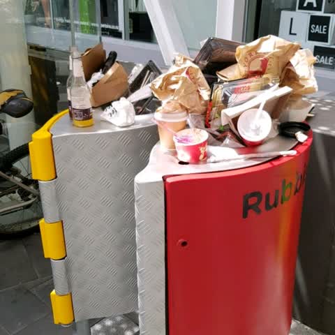
Rubbish/Recycling, 9 Jan 2018
It's 2.15 pm, and the trash bins in the BNZ Centre are overflowing!
Elsewhere on Cashel Street
- 210 Cashel Street, 53 reports
- 219 Cashel Street, 46 reports
- 208 Cashel Street, 42 reports
- 202 Cashel Street, 42 reports
- 76 Cashel Street, 39 reports
- 7 Cashel Street, 37 reports
- 135 Cashel Street, 37 reports
- 75 Cashel Street, 34 reports
The street’s crash record
NZTA’s record names Cashel Street in 103 crashes that hurt somebody since 2006, 1 person killed, 9 seriously hurt.
The civic layer
This ground votes in Central ward, the Papanui-Innes-Central community board is its local layer. Ward lines don’t always follow suburb lines; this one is measured at the pin, not the suburb’s centre. The whole roll is at /wards.
Cashel Street, the whole record → · Everything about Christchurch Central City → · What stood on this ground → · On the map → · From the air, RetroLens holds the Crown’s aerials back to 1936; search the address there →
Questions, answered briefly
7 council reports on record since January 2018, most often graffiti on a fence, building or structure (2), street cleaning (1), rubbish/recycling (1).
Christchurch Central City, Christchurch, on Cashel Street.
The heritage register names 5 places at or beside it, Former Beaths Department Store (components), Triangle Reserve and Setting.
City Mall, 91 m to its edge.