173 Saint Asaph Street, Christchurch Central City
18 reports on record since November 2019 · 15 with photographs. The street’s heaviest record is 207 Saint Asaph Street — 79 reports on file. Indicative rating valuation and school zones, hazards, bin day and what stood here before.
What gets reported here
- Pavement - Damaged — 4
- Graffiti — 4
- Water Supply — 1
- Water Leak — 1
- Water General — 1
- Roading/Streets — 1
Photographed here 15 on record


Reported here
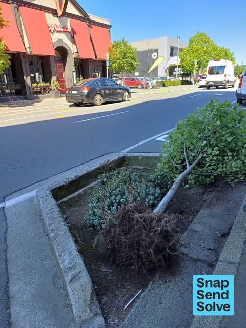
 Fallen Tree —
Tree has come completely out of ground in tree pit garden at 177 St Asaph Street (outside Ao Tawhiti Unlimited Discovery school). The root b
 Graffiti on a bus stop or public toilet —
Graffiti at the bus stop
 Pavement - Damaged —
Bench seat is missing creating a trip hazard
 Graffiti on a sign, mural or public art —
Stickers covering part of sign.
 Damaged Road —
Shared road in south frame laneway. Bollard appears to have been moved
 Pavement - Damaged —
Concrete seat / bollard has been damaged including damage to pavement
 Graffiti on a cabinet, pole or railway asset —
8 Rockgas assets all badly tagged by 173 St Asaph Street.
 Pavement - Damaged —
Seat has been moved by Contractor and not put back
 Water General —
Sinkhole next to water meter
 Facility - General Request —
Seat knocked off pins, needs to be reset.
 Pavement - Damaged —
Someone appears to have seriously damaged on of the concrete bench seats that are in sugar loaf lane. When you fix it I wonder if it would
- Graffiti —
- Graffiti —
- Water Leak —
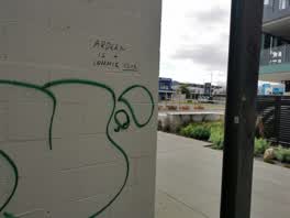
 Graffiti —
Offensive graffetti on wall inside Mata commons
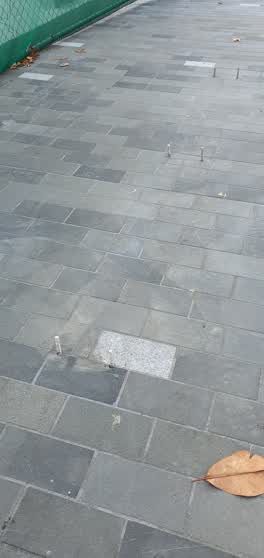 Roading/Streets —
Screw bolts are protruding from pavement and are a trip hazard. Need to be ground back?
 Graffiti —
Water Supply —
leaking pipe
Also reported on Saint Asaph Street
- 207 Saint Asaph Street — 79 reports
- 56 Saint Asaph Street — 55 reports
- 303 Saint Asaph Street — 55 reports
- 295 Saint Asaph Street — 54 reports
- 215 Saint Asaph Street — 46 reports
- 255 Saint Asaph Street — 44 reports
- 270 Saint Asaph Street — 42 reports
- 251 Saint Asaph Street — 41 reports
The green nearby
- Friendship Corner — 296 m to the edge · Botanic
- Tiffany Reserve — 319 m to the edge
- City Mall — 338 m to the edge
- Bridge Of Remembrance — 361 m to the edge · Botanic
- Excelsior Hotel Reserve — 377 m to the edge · Botanic
Parks within half a kilometre, measured to the boundary — the council’s open data.
The civic shelf nearby
- Re:start - Lichfield St — 149 m away · Car park
- Triangle — 393 m away · Car park
- Scales — 481 m away · Car park
Libraries, halls and the rest within half a kilometre — the council’s open data.
On the doorstep
- Closed - Otto Delicatessen Sandwich Bar — 6 m away · Fast food
- Ceylon Kitchen — 8 m away · Fast food
- Golden Lotus — 10 m away · Restaurants
- The Yard — 10 m away · Restaurants
Businesses within four hundred metres, measured at the pin — OpenStreetMap and the council directories.
The bus nearby
- St Asaph St near Colombo St — 38 m away · route 3, route 5, route 7, route 60, route 80, route 81, route 84, route 85, route 86
- Bus Interchange (Platform A) — 186 m away · route 3, route 5, route 60, route 80, route 81, route 84, route 85, route 86
The closest Metro stops, within four hundred and fifty metres.
The tracks through here
- Walk and bike track through Christchurch Central City — 92 m to the line · walk · bike
- Walk and bike track through Christchurch Central City — 283 m to the line · walk · bike
- Walk and bike track through Christchurch Central City — 290 m to the line · walk · bike
- Walk and bike track through Christchurch Central City — 314 m to the line · walk · bike
- Walk and bike track through Christchurch Central City — 331 m to the line · walk · bike
Tracks whose line passes within half a kilometre, measured to the line itself — the council’s open data.
The named ground
Named water within 500 m of this address, measured to the line or the edge; Named places within 1.5 km of this address — the open map’s record.
Renting nearby
new bonds in Christchurch Central City ran about $508 a week — $42 below the city median of $550 — the suburb page keeps the rent record →.
What was here — Colonial Motor Company Garage and Setting
168 m away · 201 St Asaph Street · located to ±40 m · the place’s own record →
On the register. Nothing researched here yet.
What was here — St Michael's School Hall and Setting
208 m away · 243 Durham Street South · located to ±14 m · the place’s own record →
On the register. Nothing researched here yet.
What was here — Former P & D Duncan Ltd Building and Setting
214 m away · 7/204 St Asaph Street · located to ±18 m · the place’s own record →
On the register. Nothing researched here yet.
What was here — Former R. Buchanan & Sons' City Foundry and Setting
236 m away · 2/210 St Asaph Street · located to ±14 m · the place’s own record →
On the register. Nothing researched here yet.
What was here — St Michael's School Stone Building and Setting
242 m away · located to ±16 m · the place’s own record →
On the register. Nothing researched here yet.
The civic layer
This ground votes in Central ward — the Papanui-Innes-Central community board. Ward lines don’t always follow suburb lines; this one is measured at the pin, not the suburb’s centre.
What stood on this ground → · On the map → · From the air — the Crown’s aerials back to 1936; search the address on RetroLens →
Questions, answered briefly
18 council reports on record since November 2019 — most often pavement - damaged (4), graffiti (4), water supply (1).
Christchurch Central City, Christchurch — on Saint Asaph Street.
The heritage register names 5 places at or beside it — Colonial Motor Company Garage and Setting, St Michael's School Hall and Setting.
Friendship Corner — 296 m to its edge.