226 Salisbury Street, Christchurch Central City
12 reports on record since June 2015 · 8 with photographs. The street’s heaviest record is 118 Salisbury Street — 26 reports on file. Indicative rating valuation and school zones, hazards, bin day and what stood here before.
What gets reported here
- Rubbish and Bins - General — 2
- Pavement - Damaged — 2
- Graffiti on a fence, building or structure — 2
- General Request — 2
- Dumped Rubbish — 2
- Rubbish/Recycling — 1
Photographed here 8 on record


Reported here
 General Request —
230 Salisbury st has installed new lights. The light is very bright (photos at 6.10am) and limits ability to sleep. This would breach Christ
 Graffiti on a fence, building or structure —
graffiti stickers on light lamp post pole
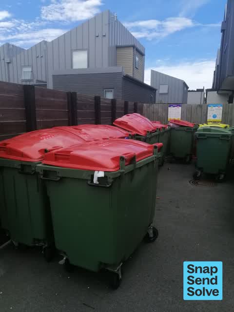
 Rubbish and Bins - General —
This Rubbish is filled with food scraps dirty nappies for nearly 3 weeks. Health and Safety Issue.Pitcalthy Body Corp notified on several oc
 Graffiti on a fence, building or structure —
226 Salisbury Street ch ch nz
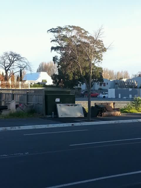
 Dumped Rubbish —
Green lime scooter dumped outside 226 Salisbury St Ch Ch central by lift box
 Dumped Rubbish —
blackbox dumped outside 226 Salisbury Street. Grey apartment block.
 Rubbish and Bins - General —
Red bins not emptied full to the brim. No room for more rubbish. 226 Sailsbury Street
- Pavement - Damaged —
- Graffiti —
- Pavement - Damaged —
- General Request —
Rubbish/Recycling —
Also reported on Salisbury Street
- 118 Salisbury Street — 26 reports
- 224 Salisbury Street — 17 reports
- 5 Salisbury Street — 16 reports
- 95 Salisbury Street — 15 reports
- 104 Salisbury Street — 15 reports
- 251B Salisbury Street — 13 reports
- 56 Salisbury Street — 12 reports
- 245 Salisbury Street — 12 reports
The street’s crash record
NZTA’s record names Salisbury Street in 84 crashes that hurt somebody since 2006 — 2 people killed, 14 seriously hurt.
The green nearby
- Moa Reserve — 158 m to the edge
- Cambridge Green — 169 m to the edge
- Barbadoes Cemetery — 175 m to the edge · Botanic · 3 ha
- Avon Riverbank Central City — 186 m to the edge · 6 ha
- Fire Fighters Reserve — 232 m to the edge
Parks within half a kilometre, measured to the boundary — the council’s open data.
On the doorstep
- Coffee Cafe — 101 m away · Fast food
- The Salisbury Hotel — 115 m away · Hotels
- Fox and Associates — 161 m away · Surveyors
- South Architects — 168 m away · Architects
Businesses within four hundred metres, measured at the pin — OpenStreetMap and the council directories.
The bus nearby
- Manchester St near Salisbury St — 318 m away · route 1, route 27, route 29, route 44, route 95
- Manchester St near Salisbury St — 337 m away · route 44
The closest Metro stops, within four hundred and fifty metres.
The tracks through here
- Walk and bike track through Christchurch Central City — 95 m to the line · walk · bike
- Walk and bike track through Christchurch Central City — 161 m to the line · walk · bike
- Walk and bike track through Christchurch Central City — 177 m to the line · walk · bike
- Walk and bike track through Christchurch Central City — 197 m to the line · walk · bike
- Walk and bike track through Christchurch Central City — 221 m to the line · walk · bike
Tracks whose line passes within half a kilometre, measured to the line itself — the council’s open data.
The named ground
Named water within 500 m of this address, measured to the line or the edge; Named places within 1.5 km of this address; the council’s own structure register — bridges, boardwalks and steps standing nearby — the open map’s record.
The remembered names nearby
- This Cairn / Marks the Site / of the / Brick Wharf — 166 m away ·
THIS CAIRN / MARKS THE SITE / OF THE / BRICK WHARF / WHERE THE / EARLY SETTLER / LANDED 18
- Plaque no. 310899 — 179 m away
- Plaque no. 310900 — 179 m away
Inscribed plaques within two hundred and fifty metres — the register’s pins, not surveyed spots. The whole roll is at /plaques.
Renting nearby
new bonds in Christchurch Central City ran about $508 a week — $42 below the city median of $550 — the suburb page keeps the rent record →.
What was here — The Bricks Site, Cairn and Setting
162 m away · 311 Oxford Terrace · located to ±35 m · the place’s own record →
On the register. Nothing researched here yet.
The civic layer
This ground votes in Central ward — the Papanui-Innes-Central community board. Ward lines don’t always follow suburb lines; this one is measured at the pin, not the suburb’s centre.
What stood on this ground → · On the map → · From the air — the Crown’s aerials back to 1936; search the address on RetroLens →
Questions, answered briefly
12 council reports on record since June 2015 — most often rubbish and bins - general (2), pavement - damaged (2), graffiti on a fence, building or structure (2).
Christchurch Central City, Christchurch — on Salisbury Street.
The heritage register names a place at or beside it — The Bricks Site, Cairn and Setting.
Moa Reserve — 158 m to its edge.