245 Montreal Street, Christchurch Central City
43 reports on record since March 2017 · 29 with photographs. The street’s heaviest record is 310 Montreal Street, 49 reports on file. Indicative rating valuation and school zones, hazards, bin day and what stood here before.
What gets reported here
Photographed here 29 on record




Reported here
 Graffiti on a fence, building or structure,
graffiti on white block fence
 Graffiti on a fence, building or structure,
graffiti on light lamp post pole nearby
 Animal - Deceased,
dead seagull
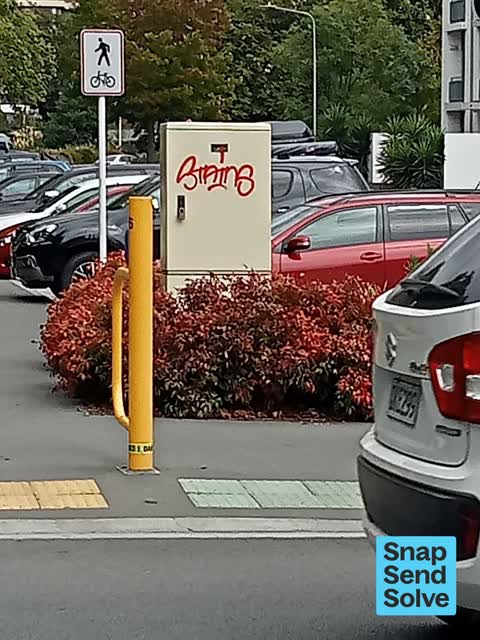
 Graffiti on a sign, mural or public art,
graffiti on side of ccc cabinet
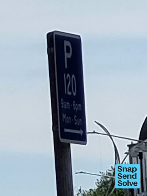
 Road Signage,
please add missing $ sign onto blue sign. this is a paid parking area.
 Hazard, vehicle,
meter not working
 Poles and Signage - General,
P$120 sign is missing $ . This is pay by plate area. Please add dollar sign.
 Poles and Signage - General,
The $ symbol is missing from this sign. It should read P$120 9am - 6pm mon- sun, not p120 9am - 6pm mon- sun.
 Graffiti on a fence, building or structure,
Graffiti on ccc managed lamp post pole
 Pavement - General,
 Graffiti on a fence, building or structure,
 Graffiti somewhere else,
 Graffiti somewhere else,
White fence
 Graffiti on a sign, mural or public art,
EKOE white paint tag on road sign by 245 Montreal Street
 Graffiti on a cabinet, pole or railway asset,
Black paint tag on concrete lamp pole by 245 Montreal Street.
 Graffiti somewhere else,
 Vandalism - General,
 Vandalism - General,
 Graffiti somewhere else,
 General Request,
Cones on Cambridge Terrace
 Graffiti on a fence, building or structure,
 Graffiti on a cabinet, pole or railway asset,
 Graffiti somewhere else,
 Graffiti on a fence, building or structure,
 Graffiti,
- Graffiti,
- Graffiti,
- Graffiti,
- Graffiti,
- Graffiti,
- Graffiti,
- Graffiti,
- Graffiti,
- Road Signage,
- Graffiti,
- Graffiti,
- Graffiti,
- Graffiti,
- Road Signage,
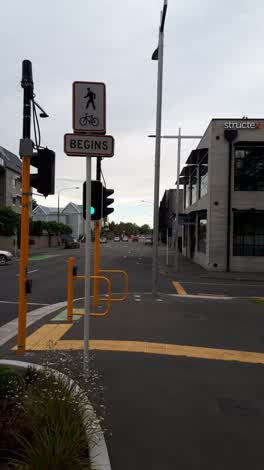 Pavement - General,
Confusing signage. It isn't obvious or clear what this sign means. Should it be facing the opposite direction? Maybe some markings on the pa
Graffiti,
footpath and fence
Graffiti,
Roading/Streets,
Dead possum
Also reported on Montreal Street
- 310 Montreal Street, 49 reports
- 262 Montreal Street, 48 reports
- 325 Montreal Street, 39 reports
- 248 Montreal Street, 35 reports
- 327 Montreal Street, 34 reports
- 208 Montreal Street, 32 reports
- 338 Montreal Street, 30 reports
- 326 Montreal Street, 30 reports
From the air, then
Sourced from Canterbury Maps and partners. LINZ, CC BY 3.0 NZ. Each frame is cut from Environment Canterbury’s historic imagery MapServer for that decade, only where the Footprints layer names a CC BY survey (NZAM-covered spots stay out). RetroLens holds more Crown aerials →
The street’s crash record
NZTA’s record names Montreal Street in 118 crashes that hurt somebody since 2006, 18 seriously hurt, nobody killed.
The green nearby
- Tiffany Reserve, 152 m to the edge
- Friendship Corner, 220 m to the edge · Botanic
- Bridge Of Remembrance, 230 m to the edge · Botanic
- Botanic Gardens, 255 m to the edge · Botanic · 21 ha
- Scott Statue Reserve, 402 m to the edge · Botanic
Parks within half a kilometre, measured to the boundary, the council’s open data.
The civic shelf nearby
- Scales, 86 m away · Car park
- Civic Offices, 279 m away · Council office
- Rolleston Avenue, 443 m away · Car park
- Re:start - Lichfield Street, 467 m away · Car park
- Christchurch Hospital Grounds, 492 m away · Car park
Libraries, halls and the rest within half a kilometre, the council’s open data.
On the doorstep
- Athfield Architects, 78 m away · Business
- PodiatryMed & Physiotherapy, 78 m away · Business
- Riverside Dental, 82 m away · Business
- Warren and Mahoney, 95 m away · Architects
Businesses within four hundred metres, measured at the pin: OpenStreetMap and the council directories.
The bus nearby
- Hereford St near Montreal St, 227 m away · route 8
- Hereford St near Montreal St, 242 m away · route 8
The closest Metro stops, within four hundred and fifty metres.
The tracks through here
- Walk and bike track through Christchurch Central City, 134 m to the line · walk · bike
- Walk and bike track through Christchurch Central City, 212 m to the line · walk · bike
- Walk and bike track through Christchurch Central City, 226 m to the line · walk · bike
- Walk and bike track through Christchurch Central City, 232 m to the line · walk · bike
- Walk and bike track through Christchurch Central City, 245 m to the line · walk · bike
Tracks whose line passes within half a kilometre, measured to the line itself, the council’s open data.
The named ground
Named water within 500 m of this address, measured to the line or the edge; Named places within 1.5 km of this address; the council’s own structure register, bridges, boardwalks and steps standing nearby, the open map’s record.
The remembered names nearby
- Rose, 226 m away ·
Rose. Soroptimist International Donated and planted by Soroptimists of Christchurch To cel
· 2009 - Planted on 14th April 1983 by His Excellency Premier Zhao, 237 m away ·
PLANTED ON 14TH APRIL 1983 BY HIS EXCELLENCY PREMIER ZHAO ZIYANG OF THE PEOPLE'S REPUBLIC
· 2009 - Halswell Quarry, 237 m away ·
HALSWELL QUARRY / (bronze plaque describing quarry history – partial)
· 2010
Inscribed plaques within two hundred and fifty metres, the register’s pins, not surveyed spots. The whole roll is at /plaques.
Renting nearby
new bonds in Christchurch Central City ran about $508 a week, $42 below the city median of $550, the suburb page keeps the rent record →.
What was here, Commercial Building and Setting
82 m away · 65 Cambridge Terrace · located to ±25 m · the place’s own record →
On the register. Nothing researched here yet.
What was here, Rhododendron Island and Setting
152 m away · 78 Cambridge Terrace · located to ±37 m · the place’s own record →
On the register. Nothing researched here yet.
What was here, Dwelling and Setting
175 m away · 23 Cashel Street · located to ±11 m · the place’s own record →
On the register. Nothing researched here yet.
What was here, Former Dwelling and Setting
178 m away · 14 Oxford Terrace · located to ±15 m · the place’s own record →
On the register. Nothing researched here yet.
What was here, St Michael and All Angels Church Belfry and Setting
188 m away · 90 Oxford Terrace · located to ±5 m · the place’s own record →
On the register. Nothing researched here yet.
The civic layer
This ground votes in Central ward, the Papanui-Innes-Central community board. Ward lines don’t always follow suburb lines; this one is measured at the pin, not the suburb’s centre.
What stood on this ground → · On the map → · From the air, the Crown’s aerials back to 1936; search the address on RetroLens →
Questions, answered briefly
43 council reports on record since March 2017, most often graffiti (15), graffiti on a fence, building or structure (6), graffiti somewhere else (5).
Christchurch Central City, Christchurch, on Montreal Street.
The heritage register names 5 places at or beside it, Commercial Building and Setting, Rhododendron Island and Setting.
Tiffany Reserve, 152 m to its edge.