258 Saint Asaph Street, Christchurch Central City
25 reports on record since August 2022 · 21 with photographs. The street’s heaviest record is 207 Saint Asaph Street — 79 reports on file. Indicative rating valuation and school zones, hazards, bin day and what stood here before.
What gets reported here
Photographed here 21 on record



Reported here
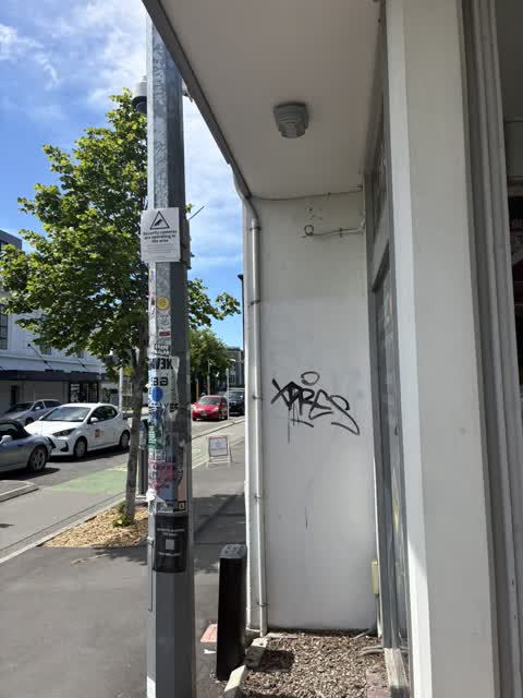
 Graffiti on a fence, building or structure —
multiple graffiti tag stickers on light lamp post pole
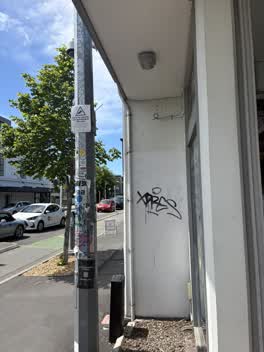 Graffiti on a fence, building or structure —
 Graffiti on a fence, building or structure —
Graffiti on a fence
 Graffiti on a fence, building or structure —
 Graffiti on a fence, building or structure —
At building wall
 Graffiti on a fence, building or structure —
 Graffiti on a fence, building or structure —
 Graffiti on a fence, building or structure —
 Graffiti on a fence, building or structure —
 Graffiti on a fence, building or structure —
 Graffiti on a fence, building or structure —
 Graffiti on a fence, building or structure —
 Graffiti on a fence, building or structure —
 Graffiti somewhere else —
 Graffiti somewhere else —
 Graffiti on a fence, building or structure —
 Graffiti on a fence, building or structure —
 Graffiti —
Coffees outside wall
- Graffiti —
- Graffiti —
- Graffiti —
- Hazard — vehicle —
 Graffiti —
Graffiti on gas meter on corner of Unknown Chapter cafe
 Graffiti —
Graffiti on boundary wall of IT engine - next to Graffiti on the gas meter boxes
 Graffiti —
Graffiti on gas meter boxes next to Steampunk laboratory restaurant
Also reported on Saint Asaph Street
- 207 Saint Asaph Street — 79 reports
- 56 Saint Asaph Street — 55 reports
- 303 Saint Asaph Street — 55 reports
- 295 Saint Asaph Street — 54 reports
- 215 Saint Asaph Street — 46 reports
- 255 Saint Asaph Street — 44 reports
- 270 Saint Asaph Street — 42 reports
- 251 Saint Asaph Street — 41 reports
The green nearby
- Wilson Park — 85 m to the edge
- Excelsior Hotel Reserve — 246 m to the edge · Botanic
- Gasson Reserve — 405 m to the edge
- Science Alive Reserve — 459 m to the edge
- City Mall — 468 m to the edge
Parks within half a kilometre, measured to the boundary — the council’s open data.
The civic shelf nearby
- St Asaph — 159 m away · Car park
- Re:start - Lichfield St — 486 m away · Car park
Libraries, halls and the rest within half a kilometre — the council’s open data.
On the doorstep
- Steampunk Laboratory — 12 m away · Fast food
- Seoul Sandwich — 15 m away · Fast food
- Unknown Chapter — 18 m away · Cafés
- Thai Box — 25 m away · Restaurants
Businesses within four hundred metres, measured at the pin — OpenStreetMap and the council directories.
The bus nearby
- Madras St near Southwark St — 88 m away · route 8, route 84, route 85, route 95
- Tuam St near Madras St — 201 m away · route 1, route 3, route 5, route 80
The closest Metro stops, within four hundred and fifty metres.
The tracks through here
- Walk and bike track through Christchurch Central City — 61 m to the line · walk · bike
- Walk and bike track through Christchurch Central City — 78 m to the line · walk · bike
- Walk and bike track through Christchurch Central City — 132 m to the line · walk · bike
- Walk and bike track through Christchurch Central City — 168 m to the line · walk · bike
- Walk and bike track through Christchurch Central City — 383 m to the line · walk · bike
Tracks whose line passes within half a kilometre, measured to the line itself — the council’s open data.
The named ground
Named places within 1.5 km of this address; the council’s own structure register — bridges, boardwalks and steps standing nearby — the open map’s record.
The remembered names nearby
- ‘corgis on High’ — Christchurch City Public Artwork — 164 m away ·
‘Corgis on High’ — Christchurch City public artwork, 6 December 2003
· 2009 - The First Public Water Supply Well Was Drilled Near This — 170 m away ·
THE FIRST PUBLIC WATER SUPPLY WELL was drilled near this site on 10 February 1864 by the C
· 2009
Inscribed plaques within two hundred and fifty metres — the register’s pins, not surveyed spots. The whole roll is at /plaques.
Renting nearby
new bonds in Christchurch Central City ran about $508 a week — $42 below the city median of $550 — the suburb page keeps the rent record →.
What was here — 129 High Street
47 m away · 1/129 High Street · located to ±17 m · the place’s own record →
On the register. Nothing researched here yet.
What was here — Commercial Building and Setting. Duncan's Buildings
52 m away · 147 High Street · located to ±45 m · the place’s own record →
On the register. Nothing researched here yet.
What was here — Commercial Building Façade and Setting, Former A J Whites
127 m away · 181 High Street · located to ±20 m · the place’s own record →
On the register. Nothing researched here yet.
What was here — Triangle Reserve and Setting
175 m away · 189F High Street · located to ±17 m · the place’s own record →
On the register. Nothing researched here yet.
What was here — Former High Street Post Office and Setting
188 m away · 209 Tuam Street · located to ±21 m · the place’s own record →
On the register. Nothing researched here yet.
The civic layer
This ground votes in Central ward — the Papanui-Innes-Central community board. Ward lines don’t always follow suburb lines; this one is measured at the pin, not the suburb’s centre.
What stood on this ground → · On the map → · From the air — the Crown’s aerials back to 1936; search the address on RetroLens →
Questions, answered briefly
25 council reports on record since August 2022 — most often graffiti on a fence, building or structure (15), graffiti (7), graffiti somewhere else (2).
Christchurch Central City, Christchurch — on Saint Asaph Street.
The heritage register names 5 places at or beside it — 129 High Street, Commercial Building and Setting. Duncan's Buildings.
Wilson Park — 85 m to its edge.