285 Cashel Street, Christchurch Central City
11 reports on record since August 2020 · 9 with photographs. The street’s heaviest record is 210 Cashel Street — 53 reports on file. Indicative rating valuation and school zones, hazards, bin day and what stood here before.
What gets reported here
Photographed here 9 on record


Reported here
 Road Signage —
 this sign is fake,cannot enforce.
 Pavement - General —
 trip hazard around water meter housing
 Road Signage —
 this sign is fake,not bookended
 Road Signage —
 signs swong the wrong way unable to enforce
 Pavement - General —
 Road signage needs removal from the footpath by 285 Cashel Street.
 Graffiti on a fence, building or structure —
 Kia ora, is CityCare able to please remove the pink graffiti from the bottom of this bench seat at 285 Cashel Street? This is a Council asse
 Dumped Rubbish —
 There's been rubbish hanging around beside the bins for 2 or 3 weeks but this is the first time I have reported it. Thanks
- Graffiti —
- Road Signage —
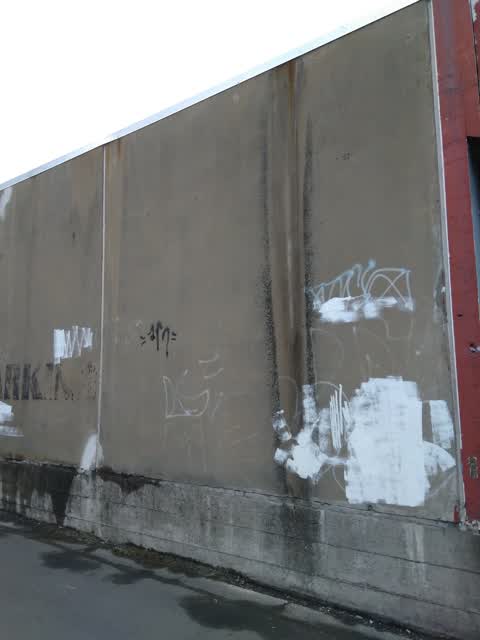
 Graffiti —
 Car park leading to Elim Early Learning Centre, on side wall of 295 Cashel Street
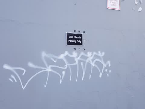
 Graffiti —
 Elim Church wall which is car parking place, Christchurch city.
Also reported on Cashel Street
- 210 Cashel Street — 53 reports
- 219 Cashel Street — 46 reports
- 202 Cashel Street — 42 reports
- 208 Cashel Street — 41 reports
- 76 Cashel Street — 39 reports
- 7 Cashel Street — 37 reports
- 135 Cashel Street — 37 reports
- 75 Cashel Street — 34 reports
The street’s crash record
NZTA’s record names Cashel Street in 103 crashes that hurt somebody since 2006 — 1 person killed, 9 seriously hurt.
The green nearby
- Latimer Square — 359 m to the edge · Botanic · 2 ha
- Worcester Pump Station Park — 485 m to the edge
- Wilson Park — 486 m to the edge
- Raglan Reserve — 491 m to the edge
Parks within half a kilometre, measured to the boundary — the council’s open data.
The civic shelf nearby
- St Asaph — 458 m away · Car park
Libraries, halls and the rest within half a kilometre — the council’s open data.
On the doorstep
- Coffee on Cashel — 3 m away · Cafés
- Daddy's Dream Cafe — 6 m away · Cafés
- Nifty — 37 m away · Clothing
- St Lui — 74 m away · Restaurants
Businesses within four hundred metres, measured at the pin — OpenStreetMap and the council directories.
The bus nearby
- Hereford St near Fitzgerald Ave — 196 m away · route 60
- Hereford St near Barbadoes St — 218 m away · route 60
The closest Metro stops, within four hundred and fifty metres.
The tracks through here
- Walk and bike track through Christchurch Central City — 255 m to the line · walk · bike
- Walk and bike track through Christchurch Central City — 258 m to the line · walk · bike
- Walk and bike track through Christchurch Central City — 258 m to the line · walk · bike
- Walk and bike track through Christchurch Central City — 462 m to the line · walk · bike
- Walk and bike track through Christchurch Central City — 473 m to the line · walk · bike
Tracks whose line passes within half a kilometre, measured to the line itself — the council’s open data.
The named ground
Named places within 1.5 km of this address; the council’s own structure register — bridges, boardwalks and steps standing nearby — the open map’s record.
Renting nearby
new bonds in Christchurch Central City ran about $508 a week — $42 below the city median of $550 — the suburb page keeps the rent record →.
What was here — St Luke's Chapel and Setting
122 m away · 272 Hereford Street · located to ±6 m · the place’s own record →
On the register. Nothing researched here yet.
The civic layer
This ground votes in Central ward — the Papanui-Innes-Central community board. Ward lines don’t always follow suburb lines; this one is measured at the pin, not the suburb’s centre.
What stood on this ground → · On the map → · From the air — the Crown’s aerials back to 1936; search the address on RetroLens →
Questions, answered briefly
11 council reports on record since August 2020 — most often road signage (4), graffiti (3), pavement - general (2).
Christchurch Central City, Christchurch — on Cashel Street.
The heritage register names a place at or beside it — St Luke's Chapel and Setting.
Latimer Square — 359 m to its edge, 2 ha.