330 Cashel Street, Christchurch Central City
21 reports on record since December 2021 · 14 with photographs. The street’s heaviest record is 210 Cashel Street — 53 reports on file. Indicative rating valuation and school zones, hazards, bin day and what stood here before.
What gets reported here
Photographed here 14 on record


Reported here
 Rubbish and Bins - General —
This bin has been dumped here and does not belong to any address in the area
 Dumped Rubbish —
Dumped furniture on Cashel Street. Not a good look before an All Black test at Te Kaha one NZ stadium. We are a business located at 326 Cash
 Rubbish and Bins - General —
This was done by rubbish collectors. Clearly someone put pizza boxes in an incorrect bin, but they didn’t need to be thrown all over the str
 Litter —
Rubbish all over the footpath
 Dumped Rubbish —
Old sheets etc dumped on the footpath by 336 Cashel Street need removal.
 Graffiti on a fence, building or structure —
Graffiti on a wall
 Graffiti on a fence, building or structure —
at oriental warehouse walls
 Rubbish and Bins - General —
This section of footpath in front of townhouses is consistently obstructed by bins and frequently littered with rubbish / dumped items throu
 Water Leak —
Meter box
 Dumped Rubbish —
Heaps of box's etc...
 Poles and Signage - General —
Found street signs on cashel street next to a power box
- Graffiti —
- Graffiti —
- Graffiti —
- Graffiti —
- Graffiti —
- Dumped Rubbish —
- Dumped Rubbish —
 Graffiti —
White paint tag on reverse side of road sign opposite 317 Cashel Street.
 Graffiti —
Black and blue paint tags on wall facing the footpath outside 317 Cashel Street.
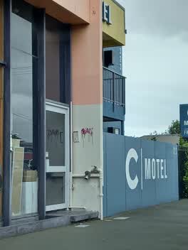 Graffiti —
Small purple graffiti on wall
Also reported on Cashel Street
- 210 Cashel Street — 53 reports
- 219 Cashel Street — 46 reports
- 202 Cashel Street — 42 reports
- 208 Cashel Street — 41 reports
- 76 Cashel Street — 39 reports
- 7 Cashel Street — 37 reports
- 135 Cashel Street — 37 reports
- 75 Cashel Street — 34 reports
The street’s crash record
NZTA’s record names Cashel Street in 103 crashes that hurt somebody since 2006 — 1 person killed, 9 seriously hurt.
The green nearby
- Raglan Reserve — 347 m to the edge
- Worcester Pump Station Park — 380 m to the edge
Parks within half a kilometre, measured to the boundary — the council’s open data.
On the doorstep
- Oriental Warehouse — 22 m away · Dairies & convenience
- C Motel — 33 m away · Motels
- Mala Foods Christchurch — 34 m away · Dairies & convenience
- AWF — 46 m away · Recruitment
Businesses within four hundred metres, measured at the pin — OpenStreetMap and the council directories.
The bus nearby
- Hereford St near Fitzgerald Ave — 138 m away · route 60
- Hereford St near Fitzgerald Ave — 143 m away · route 60
The closest Metro stops, within four hundred and fifty metres.
The tracks through here
- Walk and bike track through Christchurch Central City — 113 m to the line · walk · bike
- Walk and bike track through Christchurch Central City — 113 m to the line · walk · bike
- Walk and bike track through Christchurch Central City — 235 m to the line · walk · bike
- Walk and bike track through Christchurch Central City — 492 m to the line · walk · bike
- Walk and bike track through Christchurch Central City — 500 m to the line · walk · bike
Tracks whose line passes within half a kilometre, measured to the line itself — the council’s open data.
The named ground
Named places within 1.5 km of this address; the council’s own structure register — bridges, boardwalks and steps standing nearby — the open map’s record.
Renting nearby
new bonds in Christchurch Central City ran about $508 a week — $42 below the city median of $550 — the suburb page keeps the rent record →.
What was here — Dwelling/Commercial Building and Setting
166 m away · 147 Fitzgerald Avenue · located to ±12 m · the place’s own record →
On the register. Nothing researched here yet.
What was here — St Luke's Chapel and Setting
249 m away · 272 Hereford Street · located to ±6 m · the place’s own record →
On the register. Nothing researched here yet.
The civic layer
This ground votes in Central ward — the Papanui-Innes-Central community board. Ward lines don’t always follow suburb lines; this one is measured at the pin, not the suburb’s centre.
What stood on this ground → · On the map → · From the air — the Crown’s aerials back to 1936; search the address on RetroLens →
Questions, answered briefly
21 council reports on record since December 2021 — most often graffiti (8), dumped rubbish (5), rubbish and bins - general (3).
Christchurch Central City, Christchurch — on Cashel Street.
The heritage register names 2 places at or beside it — Dwelling/Commercial Building and Setting, St Luke's Chapel and Setting.
Raglan Reserve — 347 m to its edge.