344 Oxford Terrace, Christchurch Central City
39 reports on record since August 2018 · 28 with photographs. The street’s heaviest record is 159 Oxford Terrace, 180 reports on file. Indicative rating valuation and school zones, hazards, bin day and what stood here before.
What gets reported here
Photographed here 28 on record


Reported here
 Abandoned Vehicle,
Seems like an abandoned car on the side of the road by the river. Has been there for a few weeks. Has protest graffiti written over it and j
 Pavement - Damaged,
the builders have spilt wet concrete or cement type substance all over the footpath
 Dumped Rubbish,
dumped. thank you!
 Pothole,
pothole in road
 Graffiti on a fence, building or structure,
graffiti on fence
 Pothole,
pothole
 Graffiti on a fence, building or structure,
graffiti on grey tin fence
 Graffiti on a fence, building or structure,
Ty!
 Graffiti on a fence, building or structure,
 Abandoned Vehicle,
This car has not moved position in over 6 weeks. Expired registration. I believe it has been abandoned. Rego, make/model in the photos.
 Abandoned Vehicle,
Abandoned car. Has not moved from current position for over 6 weeks. Registration expired 01/05/2025. Registration and make/model in pictur
 Graffiti on a fence, building or structure,
 Graffiti on a fence, building or structure,
 Dumped Rubbish,
Dumped rubbish on the Avon river trail
 Graffiti on a fence, building or structure,
Black paint tag on top railing (east side) of River Avon bridge on Barbadoes Street.
 Rubbish and Bins - General,
overflowing bin
 Damaged Street Sign,
Sign is falling of the pole and is a hazard and needs remediation please
 Graffiti on a fence, building or structure,
 Graffiti on a cabinet, pole or railway asset,
 Abandoned Vehicle,
Vehicle has smashed windows. Has been parked here for weeks.
 Overgrown Vegetation,
Very overgrown vegetation
- Graffiti,
- Graffiti,
- Litter,
- Graffiti,
- Graffiti,
- Graffiti,
- Graffiti,
- Graffiti,
- Graffiti,
- Overgrown Vegetation,
- Graffiti,
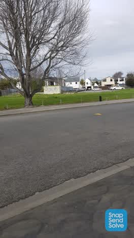 Graffiti,
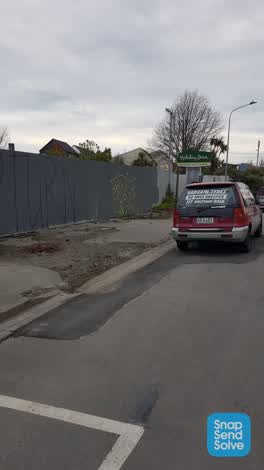 Graffiti,
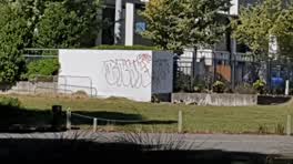 Graffiti,
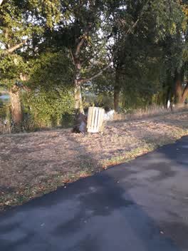 Rubbish/Recycling,
can this rubbish bag please get taken away it's on Cambridge Terrace just off Fitzgerald Ave seen it after crossing the road
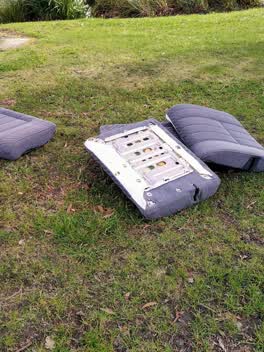 Rubbish/Recycling,
Dumped car seats
Graffiti,
Graffiti,
Also reported on Oxford Terrace
- 159 Oxford Terrace, 180 reports
- 153 Oxford Terrace, 174 reports
- 95 Oxford Terrace, 126 reports
- 211 Oxford Terrace, 126 reports
- 182 Oxford Terrace, 122 reports
- 184 Oxford Terrace, 109 reports
- 294 Oxford Terrace, 92 reports
- 152 Oxford Terrace, 87 reports
From the air, then
Sourced from Canterbury Maps and partners. LINZ, CC BY 3.0 NZ. Each frame is cut from Environment Canterbury’s historic imagery MapServer for that decade, only where the Footprints layer names a CC BY survey (NZAM-covered spots stay out). RetroLens holds more Crown aerials →
The street’s crash record
NZTA’s record names Oxford Terrace in 56 crashes that hurt somebody since 2006, 1 person killed, 11 seriously hurt.
The green nearby
- Avon Riverbank Central City, 11 m to the edge · 6 ha
- Cambridge Green, 30 m to the edge
- Barbadoes Cemetery, 92 m to the edge · Botanic · 3 ha
- Walnut Tree Park, 155 m to the edge
- Moa Reserve, 274 m to the edge
Parks within half a kilometre, measured to the boundary, the council’s open data.
On the doorstep
- Christchurch Bridge Club, 98 m away · Clubs
- Boteco Cafe & Restaurant, 147 m away · Restaurants
- Boteco, 154 m away · Cafés
- Indah, 155 m away · Hairdressers
Businesses within four hundred metres, measured at the pin: OpenStreetMap and the council directories.
The bus nearby
- Fitzgerald Ave near River Rd, 358 m away · route 7
- Fitzgerald Ave near Harvey Tce, 399 m away · route 7
The closest Metro stops, within four hundred and fifty metres.
The tracks through here
- Walk and bike track through Christchurch Central City, 44 m to the line · walk · bike
- Walk and bike track through Christchurch Central City, 55 m to the line · walk · bike
- Walk and bike track through Christchurch Central City, 72 m to the line · walk · bike
- Walk and bike track through Christchurch Central City, 166 m to the line · walk · bike
- Walk and bike track through Christchurch Central City, 228 m to the line · walk · bike
Tracks whose line passes within half a kilometre, measured to the line itself, the council’s open data.
The named ground
Named water within 500 m of this address, measured to the line or the edge; Named places within 1.5 km of this address; the council’s own structure register, bridges, boardwalks and steps standing nearby, the open map’s record.
The remembered names nearby
- This Cairn / Marks the Site / of the / Brick Wharf, 91 m away ·
THIS CAIRN / MARKS THE SITE / OF THE / BRICK WHARF / WHERE THE / EARLY SETTLER / LANDED 18
- Plaque no. 310899, 194 m away
- Plaque no. 310900, 194 m away
Inscribed plaques within two hundred and fifty metres, the register’s pins, not surveyed spots. The whole roll is at /plaques.
Renting nearby
new bonds in Christchurch Central City ran about $508 a week, $42 below the city median of $550, the suburb page keeps the rent record →.
What was here, The Bricks Site, Cairn and Setting
107 m away · 311 Oxford Terrace · located to ±35 m · the place’s own record →
On the register. Nothing researched here yet.
What was here, Commercial Building and Setting
188 m away · 228 Kilmore Street · located to ±11 m · the place’s own record →
On the register. Nothing researched here yet.
What was here, Dwelling and Setting
199 m away · 250 Kilmore Street · located to ±8 m · the place’s own record →
On the register. Nothing researched here yet.
What was here, Barbadoes Street Cemetery and Setting
227 m away · located to ±198 m · the place’s own record →
Barbadoes Street Cemetery's burial record runs in three Church of England registers: No. 1 from 9 April 1851 to 29 January 1870, No. 2 from 2 February 1870 to 3 September 1882, and No. 3 from 4 September 1882 into the 1970s.
Barbadoes Street Cemetery : alphabetical list of burials · · Christchurch City LibrariesEach register entry records when the person was buried, their name and surname, age, sex, parents' or husband's name, rank or profession, place of residence, and who performed the ceremony.
Barbadoes St Cemetery, Church of England, Register no. 1 · · Christchurch City LibrariesThe cemetery's ground was surveyed in nine historical plot plans, block by block — bordered by Barbadoes Street to the west and Cambridge Terrace to the south and east — and the plots are not consistently numbered; beside the lych-gate in block 3A, plot 780a is noted as apparently infant graves.
Barbadoes St Cemetery plan - area 1B · · Christchurch City LibrariesThe plots were sold: a separate burial plots book keeps receipt numbers, purchasers' names, plot numbers and sizes, and amounts paid, and its later pages record deposits on part-purchased plots, the completed purchase, and when title was given.
Barbadoes Street. Burial plots book · · Christchurch City LibrariesBy 1945 the cemetery sat inside a built-up city — a view across its headstones that year shows residential houses over the back fence — and by 1979 its graves and headstones were weathered, broken or fallen over; headstones still stood in the western portion in 2005.
Barbadoes Street Cemetery headstones · · Christchurch City LibrariesThe civic layer
This ground votes in Central ward, the Papanui-Innes-Central community board. Ward lines don’t always follow suburb lines; this one is measured at the pin, not the suburb’s centre.
What stood on this ground → · On the map → · From the air, the Crown’s aerials back to 1936; search the address on RetroLens →
Questions, answered briefly
39 council reports on record since August 2018, most often graffiti (14), graffiti on a fence, building or structure (8), abandoned vehicle (4).
Christchurch Central City, Christchurch, on Oxford Terrace.
The heritage register names 4 places at or beside it, The Bricks Site, Cairn and Setting, Commercial Building and Setting.
Avon Riverbank Central City, 11 m to its edge, 6 ha.