350 Cashel Street, Christchurch Central City
15 reports on record since September 2017 · 11 with photographs. The street’s heaviest record is 210 Cashel Street — 53 reports on file. Indicative rating valuation and school zones, hazards, bin day and what stood here before.
What gets reported here
Photographed here 11 on record


Reported here
 Rubbish and Bins - General —
Multiple bins left out when they shouldn’t be, on going issue between 336 and 348 Cashel street
- Litter —
The section of Cashel Street from Fitzgerald to Clarkson Ave is looking really scuzzy - bins all over the footpath all the time and loads of
 Hazard — vehicle —
black Toyota with plates nqn51 has been parked for over a week with car jutting out into traffic lane.
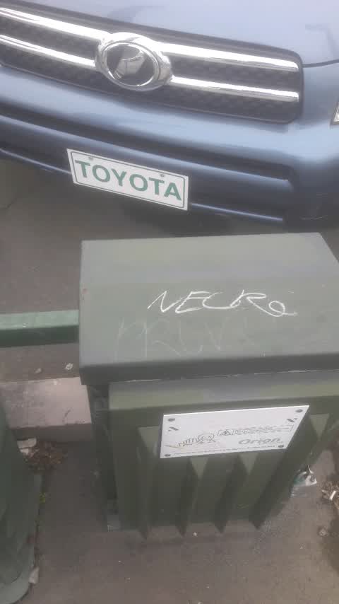
 Graffiti on a traffic light pole or cabinet, or wa —
 Graffiti on a fence, building or structure —
Car yard corner Cashel and Fitzge
 Graffiti somewhere else —
 Graffiti somewhere else —
Graffiti on the traffic lights at another conner of street
 Graffiti somewhere else —
Blue cabinet
 Graffiti on a fence, building or structure —
 Dumped Rubbish —
Fitzgerald Ave
 Poles and Signage - General —
Pedestrian crossing light not facing the right way.
- Graffiti —
- Accessibility —
- Pothole —
Graffiti —
Outside car yard
Also reported on Cashel Street
- 210 Cashel Street — 53 reports
- 219 Cashel Street — 46 reports
- 202 Cashel Street — 42 reports
- 208 Cashel Street — 41 reports
- 76 Cashel Street — 39 reports
- 7 Cashel Street — 37 reports
- 135 Cashel Street — 37 reports
- 75 Cashel Street — 34 reports
The street’s crash record
NZTA’s record names Cashel Street in 103 crashes that hurt somebody since 2006 — 1 person killed, 9 seriously hurt.
The green nearby
- Raglan Reserve — 264 m to the edge
- Worcester Pump Station Park — 325 m to the edge
Parks within half a kilometre, measured to the boundary — the council’s open data.
On the doorstep
- Cashel Street Foodmarket — 57 m away · Dairies & convenience
- Kebab & Grill Corner Linwood — 60 m away · Fast food
- C Motel — 62 m away · Motels
- C4 Coffee Co — 65 m away · Coffee roasters
Businesses within four hundred metres, measured at the pin — OpenStreetMap and the council directories.
The bus nearby
- Hereford St near Fitzgerald Ave — 124 m away · route 60
- Hereford St near Fitzgerald Ave — 155 m away · route 60
The closest Metro stops, within four hundred and fifty metres.
The tracks through here
- Walk and bike track through Christchurch Central City — 30 m to the line · walk · bike
- Walk and bike track through Christchurch Central City — 30 m to the line · walk · bike
- Walk and bike track through Christchurch Central City — 236 m to the line · walk · bike
- Walk and bike track through Christchurch Central City — 492 m to the line · walk · bike
- Walk and bike track through Christchurch Central City — 493 m to the line · walk · bike
Tracks whose line passes within half a kilometre, measured to the line itself — the council’s open data.
The named ground
Named places within 1.5 km of this address — the open map’s record.
Renting nearby
new bonds in Christchurch Central City ran about $508 a week — $42 below the city median of $550 — the suburb page keeps the rent record →.
What was here — Dwelling/Commercial Building and Setting
144 m away · 147 Fitzgerald Avenue · located to ±12 m · the place’s own record →
On the register. Nothing researched here yet.
The civic layer
This ground votes in Central ward — the Papanui-Innes-Central community board. Ward lines don’t always follow suburb lines; this one is measured at the pin, not the suburb’s centre.
What stood on this ground → · On the map → · From the air — the Crown’s aerials back to 1936; search the address on RetroLens →
Questions, answered briefly
15 council reports on record since September 2017 — most often graffiti somewhere else (3), graffiti on a fence, building or structure (2), graffiti (2).
Christchurch Central City, Christchurch — on Cashel Street.
The heritage register names a place at or beside it — Dwelling/Commercial Building and Setting.
Raglan Reserve — 264 m to its edge.