4/324 Madras Street
10 council reports since July 2022, 8 carrying a photograph. The street’s heaviest record is 153 Madras Street, 73 reports on file.
On the register here
- Former Vicarage of the Church of St Luke the Evangelist and Setting, 185 Kilmore Street (197m)
- The Bricks Site, Cairn and Setting, 311 Oxford Terrace (200m)
- Edmonds Clock Tower, Telephone Cabinet and Setting, 295F Madras Street (237m)
From the air, then
Sourced from Canterbury Maps and partners. LINZ, CC BY 3.0 NZ. Each frame is cut from Environment Canterbury’s historic imagery MapServer for that decade, only where the Footprints layer names a CC BY survey (NZAM-covered spots stay out). RetroLens holds more Crown aerials →
The green nearby
- Cambridge Reserve, 141 m to the edge
- Fire Fighters Reserve, 146 m to the edge
- Poplars Reserve, 188 m to the edge · Botanic
- Avon Riverbank Central City, 243 m to the edge · 6 ha
- Cambridge Green, 246 m to the edge
Parks within half a kilometre, measured to the boundary, the council’s open data. The whole roll is at /parks.
On the doorstep
- Fox and Associates, 67 m away · Surveyors
- South Architects, 74 m away · Architects
- Mainland Uniforms, 93 m away · Clothing
- Knit World, 102 m away · Wool
Businesses within four hundred metres, measured at the pin, OpenStreetMap and the council directories.
The bus nearby
- Manchester St near Salisbury St, 259 m away · route 1, route 27, route 29, route 44, route 95
- Manchester St near Kilmore St, 261 m away · route 1, route 27, route 29, route 44, route 91, route 92, route 95
The closest Metro stops, within four hundred and fifty metres.
The tracks through here
- Walk and bike track through Christchurch Central City, 108 m to the line · walk · bike
- Walk and bike track through Christchurch Central City, 109 m to the line · walk · bike
- Walk and bike track through Christchurch Central City, 130 m to the line · walk · bike
- Walk and bike track through Christchurch Central City, 147 m to the line · walk · bike
- Walk and bike track through Christchurch Central City, 169 m to the line · walk · bike
Tracks whose line passes within half a kilometre, the council’s open data.
The named ground
Named water within 500 m of this address, measured to the line or the edge; Named places within 1.5 km of this address; the council’s own structure register, bridges, boardwalks and steps standing nearby, the open map’s record.
The remembered names nearby
- This Tree Was Planted / to Commemorate, 148 m away ·
THIS TREE WAS PLANTED / TO COMMEMORATE / THE 10 YEARS OF SERVICE / OF THE / ALTRUSA CLUB /
· 2009 - Christchurch City Council Acknowledges Generous Support, 150 m away ·
Christchurch City Council acknowledges generous support of sponsors (full list engraved)
· 2009 - A Tribute to Firefighters Sculpture by Graham Bennett Steel, 151 m away ·
A Tribute to Firefighters Sculpture by Graham Bennett Steel from the New York World Trade
· 2009
Inscribed plaques within two hundred and fifty metres, the register’s pins, not surveyed spots. The whole roll is at /plaques.
Renting nearby
new bonds in Christchurch Central City ran about $508 a week, $42 below the city median of $550, the suburb page keeps the rent record →.
What gets reported here
Photographed here 8 on record


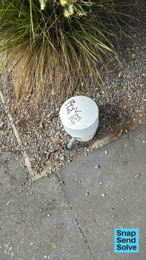
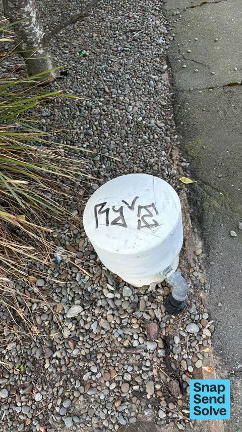


What’s on record
 Dumped Rubbish, 25 Mar 2026
Rubbish dumped 2 weeks ago
 Graffiti somewhere else, 21 Jan 2025
 Rubbish and Bins - General, 17 Dec 2024
Two dumped bins out side 211 Peterborough street
 Graffiti on a fence, building or structure, 2 Dec 2024
Black paint tag on this asset by the corner of Peterborough and Madras Streets.
 Graffiti somewhere else, 26 Sept 2024
Black paint tag on this anonymous asset by the corner of Peterborough and Madras Streets
 Dumped Rubbish, 13 Jun 2024
Broken shattered glass needs removal from the footpath on Peterborough Street at the corner of Madras Street.
 Graffiti on a fence, building or structure, 4 Apr 2024
Black paint tag on this asset by the corner of Peterborough and Madras Streets.
- Pavement - General, 16 Nov 2022
- Graffiti, 16 Nov 2022
 Graffiti, 24 Jul 2022
Blue paint tag on anonymous asset on the corner of Peterborough and Madras Streets.
Elsewhere on Madras Street
- 153 Madras Street, 73 reports
- 169 Madras Street, 50 reports
- 145 Madras Street, 49 reports
- 282 Madras Street, 37 reports
- 160 Madras Street, 35 reports
- 163 Madras Street, 32 reports
- 281 Madras Street, 29 reports
- 167 Madras Street, 28 reports
The street’s crash record
NZTA’s record names Madras Street in 161 crashes that hurt somebody since 2006, 17 seriously hurt, nobody killed.
The civic layer
This ground votes in Central ward, the Papanui-Innes-Central community board is its local layer. Ward lines don’t always follow suburb lines; this one is measured at the pin, not the suburb’s centre. The whole roll is at /wards.
Madras Street, the whole record → · Everything about Christchurch Central City → · What stood on this ground → · On the map → · From the air, RetroLens holds the Crown’s aerials back to 1936; search the address there →
Questions, answered briefly
10 council reports on record since July 2022, most often graffiti somewhere else (2), graffiti on a fence, building or structure (2), graffiti (2).
Christchurch Central City, Christchurch, on Madras Street.
The heritage register names 3 places at or beside it, Former Vicarage of the Church of St Luke the Evangelist and Setting, The Bricks Site, Cairn and Setting.
Cambridge Reserve, 141 m to its edge.