804 Colombo street Christchurch 8013 Canterbury New Zealand
1 council report since June 2022, 1 carrying a photograph.
On the register here
- Colombo Street Bridge and Setting (82m)
- The Christchurch Town Hall and Setting (113m)
- Bowker Fountain and Setting (181m)
- Former Market Place Bridge/Hamish Hay Bridge and Setting (189m)
- Captain James Cook Statue and Setting, 89 Armagh Street (198m)
The green nearby
- Victoria Square, 96 m to the edge · Botanic · 2 ha
- Edmonds Band Rotunda, 190 m to the edge · Botanic
- Canterbury Provincial Council Reserve, 312 m to the edge · Botanic
- Victoria Triangles, 325 m to the edge
- Rose Historic Chapel Reserve, 342 m to the edge · Botanic
Parks within half a kilometre, measured to the boundary, the council’s open data. The whole roll is at /parks.
The civic shelf nearby
- Aldersgate, 326 m away · Car park
- Armagh Street, 380 m away · Car park
- Turanga Library, 415 m away · Library
Libraries, halls and the rest within half a kilometre, the council’s open data.
On the doorstep
- Krung Thep Thai Street Food, 18 m away · Restaurants
- OrthoSouth, 26 m away · Dentists
- Hotel 818, 60 m away · Hotels
- Bolina Indian Sweets and Restaurant, 65 m away · Restaurants
Businesses within four hundred metres, measured at the pin, OpenStreetMap and the council directories.
The bus nearby
- Kilmore St near Manchester St, 120 m away · route 1, route 27, route 29, route 95
- Kilmore Street Town Hall, 125 m away · route 1, route 29, route 95
The closest Metro stops, within four hundred and fifty metres.
The tracks through here
- Walk and bike track through Christchurch Central City, 240 m to the line · walk · bike
- Walk and bike track through Christchurch Central City, 244 m to the line · walk · bike
- Walk and bike track through Christchurch Central City, 261 m to the line · walk · bike
- Walk and bike track through Christchurch Central City, 280 m to the line · walk · bike
- Walk and bike track through Christchurch Central City, 292 m to the line · walk · bike
Tracks whose line passes within half a kilometre, the council’s open data.
The named ground
Named water within 500 m of this address, measured to the line or the edge; Named places within 1.5 km of this address; the council’s own structure register, bridges, boardwalks and steps standing nearby, the open map’s record.
The remembered names nearby
- Scottish Pioneer Tribute, 48 m away ·
SCOTTISH PIONEER TRIBUTE / This plaque celebrates and pays tribute to the Scottish Pioneer
- He Poupou Tohu Ahi-Kā o Ngāi Tahu, 151 m away ·
He poupou tohu ahi-kā o Ngāi Tahu / A mark of the long burning fires of Ngāi Tahu
· 2018 - Bowker Fountain / Unveiled 26 February 1931, 180 m away ·
BOWKER FOUNTAIN / UNVEILED 26 FEBRUARY 1931 / REPAIRED AND RECONSTRUCTED / AFTER THE 2011
· 2018
Inscribed plaques within two hundred and fifty metres, the register’s pins, not surveyed spots. The whole roll is at /plaques.
Renting nearby
new bonds in Christchurch Central City ran about $508 a week, $42 below the city median of $550, the suburb page keeps the rent record →.
What gets reported here
Photographed here 1 on record
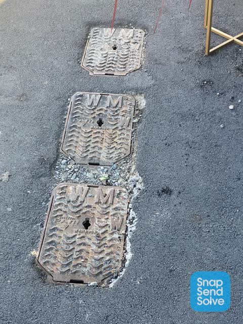
What’s on record
 Roading/Streets, 23 Jun 2022
Trip hazard Out of level Retains water and ice over
The civic layer
This ground votes in Central ward, the Papanui-Innes-Central community board is its local layer. Ward lines don’t always follow suburb lines; this one is measured at the pin, not the suburb’s centre. The whole roll is at /wards.
Colombo street Christchurch 8013 Canterbury New Zealand, the whole record → · Everything about Christchurch Central City → · What stood on this ground → · On the map → · Street View → · From the air, RetroLens holds the Crown’s aerials back to 1936; search the address there →
Questions, answered briefly
1 council report on record since June 2022, most often roading/streets (1).
Christchurch Central City, Christchurch, on Colombo street Christchurch 8013 Canterbury New Zealand.
The heritage register names 5 places at or beside it, Colombo Street Bridge and Setting, The Christchurch Town Hall and Setting.
Victoria Square, 96 m to its edge, 2 ha.