820 Colombo Street, Christchurch Central City
12 reports on record since July 2016 · 12 with photographs. The street’s heaviest record is 794 Colombo Street — 159 reports on file. Indicative rating valuation and school zones, hazards, bin day and what stood here before.
What gets reported here
Photographed here 12 on record


Reported here
 Graffiti on a fence, building or structure —
 Black paint tags on metal gatepost facing the footpath at 820 Colombo Street presents.
 Graffiti on a fence, building or structure —
 Graffiti on side of building
 Graffiti on a fence, building or structure —
 Graffiti
 Graffiti on a fence, building or structure —
  Graffiti on a fence, building or structure —
 Spray paint
 Graffiti somewhere else —
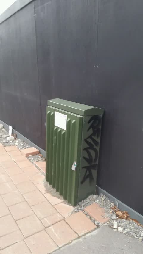
 Graffiti on Orion box
 Graffiti somewhere else —
  Graffiti on a fence, building or structure —
 Black paint tag (plus multiple paint tags on the adjacent wall) on metal post facing the footpath at 820 Colombo Street.
 Graffiti on a fence, building or structure —
 white graffiti on black wall
 Graffiti —
  Graffiti —
 On wall above parking spaces.
Graffiti —
Graffiti on orion box
Also reported on Colombo Street
- 794 Colombo Street — 159 reports
- 673 Colombo Street — 102 reports
- 781 Colombo Street — 55 reports
- 521 Colombo Street — 46 reports
- 722 Colombo Street — 45 reports
- 569 Colombo Street — 45 reports
- 527 Colombo Street — 41 reports
- 711 Colombo Street — 38 reports
The street’s crash record
NZTA’s record names Colombo Street in 177 crashes that hurt somebody since 2006 — 1 person killed, 32 seriously hurt.
The green nearby
- Victoria Square — 166 m to the edge · Botanic · 2 ha
- Edmonds Band Rotunda — 245 m to the edge · Botanic
- Rose Historic Chapel Reserve — 272 m to the edge · Botanic
- Aldred Reserve — 298 m to the edge
- Victoria Triangles — 325 m to the edge
Parks within half a kilometre, measured to the boundary — the council’s open data.
The civic shelf nearby
- Aldersgate — 373 m away · Car park
- Armagh St — 430 m away · Car park
- Turanga Library — 484 m away · Library · Cathedral Square, Christchurch
Libraries, halls and the rest within half a kilometre — the council’s open data.
On the doorstep
- One shop Convenience — 9 m away · Dairies & convenience
- Hotel 818 — 13 m away · Hotels
- The Herbal Dispensary Store — 15 m away · Delis
- Bolina Indian Sweets and Restaurant — 23 m away · Restaurants
Businesses within four hundred metres, measured at the pin — OpenStreetMap and the council directories.
The bus nearby
- Kilmore St near Manchester St — 146 m away · route 1, route 27, route 29, route 95
- Kilmore Street Town Hall — 160 m away · route 1, route 29, route 95
The closest Metro stops, within four hundred and fifty metres.
The tracks through here
- Walk and bike track through Christchurch Central City — 233 m to the line · walk · bike
- Walk and bike track through Christchurch Central City — 234 m to the line · walk · bike
- Walk and bike track through Christchurch Central City — 266 m to the line · walk · bike
- Walk and bike track through Christchurch Central City — 331 m to the line · walk · bike
- Walk and bike track through Christchurch Central City — 359 m to the line · walk · bike
Tracks whose line passes within half a kilometre, measured to the line itself — the council’s open data.
The named ground
Named water within 500 m of this address, measured to the line or the edge; Named places within 1.5 km of this address; the council’s own structure register — bridges, boardwalks and steps standing nearby — the open map’s record.
The remembered names nearby
- Scottish Pioneer Tribute — 111 m away ·
SCOTTISH PIONEER TRIBUTE / This plaque celebrates and pays tribute to the Scottish Pioneer
- He Poupou Tohu Ahi-Kä o Ngäi Tahu — 219 m away ·
He poupou tohu ahi-kÄ o NgÄi Tahu / A mark of the long burning fires of NgÄi Tahu
· 2018 - Bowker Fountain / Unveiled 26 February 1931 — 249 m away ·
BOWKER FOUNTAIN / UNVEILED 26 FEBRUARY 1931 / REPAIRED AND RECONSTRUCTED / AFTER THE 2011
· 2018
Inscribed plaques within two hundred and fifty metres — the register’s pins, not surveyed spots. The whole roll is at /plaques.
Renting nearby
new bonds in Christchurch Central City ran about $508 a week — $42 below the city median of $550 — the suburb page keeps the rent record →.
What was here — Colombo Street Bridge and Setting
152 m away · located to ±24 m · the place’s own record →
On the register. Nothing researched here yet.
What was here — The Christchurch Town Hall and Setting
172 m away · located to ±79 m · the place’s own record →
On the register. Nothing researched here yet.
The civic layer
This ground votes in Central ward — the Papanui-Innes-Central community board. Ward lines don’t always follow suburb lines; this one is measured at the pin, not the suburb’s centre.
What stood on this ground → · On the map → · From the air — the Crown’s aerials back to 1936; search the address on RetroLens →
Questions, answered briefly
12 council reports on record since July 2016 — most often graffiti on a fence, building or structure (7), graffiti (3), graffiti somewhere else (2).
Christchurch Central City, Christchurch — on Colombo Street.
The heritage register names 2 places at or beside it — Colombo Street Bridge and Setting, The Christchurch Town Hall and Setting.
Victoria Square — 166 m to its edge, 2 ha.