88 Armagh Street, Christchurch Central City
89 reports on record since July 2016 · 71 with photographs. The street’s heaviest record is 177 Armagh Street — 266 reports on file. Indicative rating valuation and school zones, hazards, bin day and what stood here before.
What gets reported here
- Graffiti — 26
- Graffiti on a fence, building or structure — 24
- Graffiti somewhere else — 11
- Vandalism - General — 8
- General Request — 4
- Roading/Streets — 3
Photographed here 71 on record


Reported here the newest 80 of 89
 Graffiti on a fence, building or structure —
 graffiti on green fence
 Graffiti on a fence, building or structure —
  Poles and Signage - General —
 Bollard damaged
 Graffiti on a fence, building or structure —
  Graffiti on a fence, building or structure —
 graffiti on green tin fence
 Graffiti on a fence, building or structure —
 Graffiti Across the side of the building
 Pest / Vermin —
 Wasps nest in the rotting cabbage trees. noticed wasps emerging 8am this morning from hollow in the tree
 Graffiti on a fence, building or structure —
 graffiti Across the side of the building
 Graffiti on a fence, building or structure —
 green tin fence
 Graffiti on a fence, building or structure —
  Graffiti on a fence, building or structure —
 Graffiti on fence
 Graffiti on a fence, building or structure —
 Tagging on corrugated gate fence and roof aroundmd the building
 Graffiti on a fence, building or structure —
  Graffiti on a fence, building or structure —
  Graffiti on a fence, building or structure —
 Graffiti on fence
 Graffiti on a fence, building or structure —
  Graffiti on a fence, building or structure —
 Graffiti on ccc managed light pole
 Graffiti on a fence, building or structure —
 Green fence
 Graffiti on a fence, building or structure —
 Graffiti across the side of the building.
 Graffiti on a fence, building or structure —
 Back of Majistrates historical building
 General Request —
  Graffiti on a fence, building or structure —
 Old court building near Te Pae
 Poles and Signage - General —
 The plague for the hitch point has been removed (photo 1 and 2) photo 3 shows it in place. "This ramp, to facilitate the watering of horses,
 Graffiti on a sign, mural or public art —
 Graffiti on bridge sign
 Graffiti somewhere else —
 Graffiti on bollards of bridge
 General Request —
 Missing information placard
 Vandalism - General —
 Someone has unscrewed and removed one of the cast iron balls on the southern balustrade of the Armagh Street bridge. I Couldn't see it on th
 Graffiti somewhere else —
 Graffiti on pillar, ansteigen signs
 Water General —
 Barrier fell in the Avon
 Graffiti somewhere else —
  Graffiti somewhere else —
  Vandalism - General —
  Graffiti somewhere else —
 Southside of Armagh bridge on a green iron fence
 Graffiti somewhere else —
 Graffiti on railings of bridge
 Vandalism - General —
 Bollard removed, location shown
 Graffiti somewhere else —
  Vandalism - General —
 One of the ornate bollards on the footpath beside the Armagh street bridge has been knocked over and then dumped in the river (upstream side
 Graffiti somewhere else —
 Graffiti on the back of heavy load sign on bridge on Armagh st next to te pae
 Poles and Signage - General —
 Road-cone in river by bridge
 Graffiti somewhere else —
 Parks team couldn’t remove
 Pavement - General —
 Hole in ground from old post
 Vandalism - General —
 Broken door
- Vandalism - General —
 Graffiti somewhere else —
 Parks team couldn’t remove
 Graffiti on a fence, building or structure —
  Graffiti on a fence, building or structure —
 Next old courtroom..x3
 Graffiti on a fence, building or structure —
 Parks team couldn’t remove graffiti
 Graffiti somewhere else —
 West side of bridge on Southside near bridge railing near Avon river
 Graffiti on a fence, building or structure —
 Yellow paint tag on railing of River Avon bridge on the west side of the bridge on Armagh Street. Also multiple paint tags on the fence just
 Graffiti on a fence, building or structure —
 Silver paint tag on River Avon bridge rail on western end of the bridge on Armagh Street.
 Park - General Request —
 Lime scooter in the acon river
 Graffiti on a sign, mural or public art —
  Graffiti —
  Water Leak —
 A water leak on the pipe to a potable water tap just behind the gate of the canterbury Provincial chambers
 Water Pollution - Sediment —
 Something being discharged into River Avon
 General Request —
 - Graffiti —
- Graffiti —
- General Request —
- Graffiti —
- Graffiti —
- Graffiti —
- Graffiti —
- Graffiti —
- Graffiti —
- Graffiti —
- Graffiti —
- Graffiti —
- Graffiti —
- Graffiti —
- Graffiti —
- Vandalism - General —
- Vandalism - General —
 Graffiti —
 3 blue paint tags on door and fence on the western side of Armagh Street bridge on The Avon River, facing the footpath.
 Graffiti —
 Blue paint tag on concrete plinth on Armagh Street bridge on The Avon River.
 Graffiti —
 On fence west side Armagh St bridge opposite #85 Armagh St
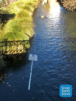 Roading/Streets —
 Road sign in river. Also a chair.
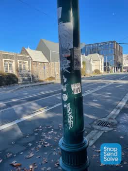 Graffiti —
 Significant amount of graffiti in this area
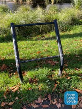 Parks —
 Sign contents are missing from the display
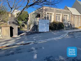 Graffiti —
 Significant amount of graffiti in this area
9 more on record — the live page pages them.
Also reported on Armagh Street
- 177 Armagh Street — 266 reports
- 90 Armagh Street — 234 reports
- 163 Armagh Street — 116 reports
- 167 Armagh Street — 109 reports
- 89 Armagh Street — 107 reports
- 199 Armagh Street — 74 reports
- 161 Armagh Street — 63 reports
- 4 Armagh Street — 61 reports
The street’s crash record
NZTA’s record names Armagh Street in 86 crashes that hurt somebody since 2006 — 13 seriously hurt, nobody killed.
The green nearby
- Canterbury Provincial Council Reserve — 4 m to the edge · Botanic
- Victoria Square — 23 m to the edge · Botanic · 2 ha
- Godley Statue Reserve — 242 m to the edge · Botanic
- Cathedral Square — 245 m to the edge · Botanic
- Scott Statue Reserve — 260 m to the edge · Botanic
Parks within half a kilometre, measured to the boundary — the council’s open data.
The civic shelf nearby
- Aldersgate — 144 m away · Car park
- Armagh St — 148 m away · Car park
- Turanga Library — 254 m away · Library · Cathedral Square, Christchurch
- Civic Offices — 408 m away · Council office
- Triangle — 487 m away · Car park
Libraries, halls and the rest within half a kilometre — the council’s open data.
On the doorstep
- Millie's House — 39 m away · Childcare
- Prison Escape — 52 m away · Attractions
- Ice Cream Charlie — 61 m away · Fast food
- Te Pae Convention Centre — 74 m away · Business
Businesses within four hundred metres, measured at the pin — OpenStreetMap and the council directories.
The bus nearby
- Kilmore Street Town Hall — 243 m away · route 1, route 29, route 95
- Kilmore St near Manchester St — 367 m away · route 1, route 27, route 29, route 95
The closest Metro stops, within four hundred and fifty metres.
The tracks through here
- Walk and bike track through Christchurch Central City — 2 m to the line · walk · bike
- Walk and bike track through Christchurch Central City — 32 m to the line · walk · bike
- Walk and bike track through Christchurch Central City — 142 m to the line · walk · bike
- Walk and bike track through Christchurch Central City — 240 m to the line · walk · bike
- Walk and bike track through Christchurch Central City — 256 m to the line · walk · bike
Tracks whose line passes within half a kilometre, measured to the line itself — the council’s open data.
The named ground
Named water within 500 m of this address, measured to the line or the edge; Named places within 1.5 km of this address; the council’s own structure register — bridges, boardwalks and steps standing nearby — the open map’s record.
The remembered names nearby
- Ettie Rout 1877–1936 Guardian Angel of the ANZAC — 40 m away ·
ETTIE ROUT 1877–1936 GUARDIAN ANGEL OF THE ANZAC
· 2009 - Gifted to the City by the Descendants — 55 m away ·
GIFTED TO THE CITY BY THE DESCENDANTS OF / STEPHEN AND REBECCA BROOKER / OCTOBER 1991 / BR
· 2018 - This Ramp, to Facilitate the Watering of Horses, Was Built — 57 m away ·
THIS RAMP, TO FACILITATE THE WATERING OF HORSES, WAS BUILT IN DECEMBER 1874. / CHRISTCHURC
· 2026
Inscribed plaques within two hundred and fifty metres — the register’s pins, not surveyed spots. The whole roll is at /plaques.
Renting nearby
new bonds in Christchurch Central City ran about $508 a week — $42 below the city median of $550 — the suburb page keeps the rent record →.
What was here — Armagh Street Bridge and Setting
on this spot · located to ±18 m · the place’s own record →
On the register. Nothing researched here yet.
What was here — Canterbury Provincial Council Buildings Former Land Transfer Office
32 m away · 86 Armagh Street · located to ±15 m · the place’s own record →
On the register. Nothing researched here yet.
What was here — Armagh Street Kerbstones and Setting
44 m away · 280A Durham Street North · located to ±26 m · the place’s own record →
On the register. Nothing researched here yet.
What was here — Former Magistrates Court and Setting
46 m away · 85 Armagh Street · located to ±21 m · the place’s own record →
On the register. Nothing researched here yet.
What was here — Horse Watering Ramp and Setting
54 m away · located to ±7 m · the place’s own record →
On the register. Nothing researched here yet.
The civic layer
This ground votes in Central ward — the Papanui-Innes-Central community board. Ward lines don’t always follow suburb lines; this one is measured at the pin, not the suburb’s centre.
What stood on this ground → · On the map → · From the air — the Crown’s aerials back to 1936; search the address on RetroLens →
Questions, answered briefly
89 council reports on record since July 2016 — most often graffiti (26), graffiti on a fence, building or structure (24), graffiti somewhere else (11).
Christchurch Central City, Christchurch — on Armagh Street.
The heritage register names 5 places at or beside it — Armagh Street Bridge and Setting, Canterbury Provincial Council Buildings Former Land Transfer Office.
Canterbury Provincial Council Reserve — 4 m to its edge.