1 Ferrymead Terrace, Ferrymead
36 reports on record since January 2020 · 25 with photographs. The street’s heaviest record is 3 Ferrymead Terrace — 38 reports on file. Indicative rating valuation and school zones, hazards, bin day and what stood here before.
What gets reported here
Photographed here 25 on record




Reported here
 Graffiti on a traffic light pole or cabinet, or wa —
  Graffiti on a traffic light pole or cabinet, or wa —
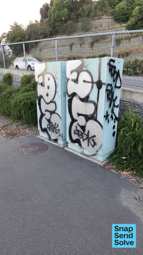
 Graffiti on traffic signal controller box
 Graffiti on a traffic light pole or cabinet, or wa —
 Graffiti on traffic control cabinets near here start of main road ferry mead
 Road Blockage —
 Fallen tree
 Graffiti on a fence, building or structure —
 Graffitti on signs, boxes, walls. Also on signs on coastal walk way
 Graffiti on a fence, building or structure —
 Graffiti on wall beside tried to get photo as we past
 Graffiti on a fence, building or structure —
 Graffiti on every council box
 Graffiti on a cabinet, pole or railway asset —
 Ferrymead Bridge Corner.. lots of cabinets across town covered? Are they CCC responsibility?
 Graffiti somewhere else —
  Graffiti somewhere else —
  Graffiti on a cabinet, pole or railway asset —
  Graffiti on a fence, building or structure —
  Graffiti on a fence, building or structure —
  Graffiti somewhere else —
  Graffiti somewhere else —
  Graffiti somewhere else —
 Several graffiti that we could not stop and photograph
 Road Signage —
 Both 2 lane merge signs on Eastbound of Main Road after Bridle Path Road traffic lights have been turned round, so can't be seen Eastbound.
 Graffiti —
 - Graffiti —
- Graffiti —
- Graffiti —
- Roads - General —
- Graffiti —
- Graffiti —
- Poles and Signage - General —
- Overgrown Vegetation —
- Overgrown Vegetation —
- Graffiti —
 Pavement - General —
 Could this safe waiting space be cleaned please. It's months since anyone too a look at it and it's becoming a trip hazard now.
 Graffiti —
 Hi there... I previously reported this and nothing has been done. Now that it's has been left it has been added to. Can we have this removed
 Graffiti —
 Graffiti on retaining wall
 Graffiti —
  Graffiti —
  Parks —
 Lots of weeds!
Rubbish/Recycling —
Pile of rubbish by building.
- Roading/Streets —
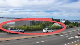
lane merge sign facing the wrong way. traffic to Sumner is merging from 2 to 1 lanes, but sign is facing towards traffic from Sumner.
Also reported on Ferrymead Terrace
- 3 Ferrymead Terrace — 38 reports
- 5 Ferrymead Terrace — 20 reports
- 11 Ferrymead Terrace — 11 reports
- 7 Ferrymead Terrace — 3 reports
- 9 Ferrymead Terrace — 2 reports
The street’s crash record
NZTA’s record names Ferrymead Terrace in 5 crashes that hurt somebody since 2006 — 5 seriously hurt, nobody killed.
The green nearby
- Scott Park Ferrymead — 19 m to the edge · 2 ha
- Settlers Reserve — 140 m to the edge · 13 ha
- Te Awakura Reserve — 221 m to the edge
- Ferrymead Reserve — 355 m to the edge · Botanic · 1 ha
- The Brae — 358 m to the edge
Parks within half a kilometre, measured to the boundary — the council’s open data.
On the doorstep
- The Kebab King Ferrymead — 207 m away · Fast food
- Claddagh — 209 m away · Bars & pubs
- Anytime Fitness — 211 m away · Gyms & fitness
- Best Turkish Food Co. — 212 m away · Restaurants
Businesses within four hundred metres, measured at the pin — OpenStreetMap and the council directories.
The bus nearby
- Main Rd near St Andrews Hill Rd — 48 m away · route 3
- Main Rd near Te Awakura Tce — 164 m away · route 3
The closest Metro stops, within four hundred and fifty metres.
The tracks through here
- Walk and bike track through Ferrymead — 5 m to the line · walk · bike
- Walk and bike track through Ferrymead — 5 m to the line · walk · bike
- Walk and bike track through Ferrymead — 70 m to the line · walk · bike
- Walk and bike track through Ferrymead — 160 m to the line · walk · bike
- Walk and bike track through Ferrymead — 168 m to the line · walk · bike
Tracks whose line passes within half a kilometre, measured to the line itself — the council’s open data.
The named ground
Named water within 500 m of this address, measured to the line or the edge; the council’s own structure register — bridges, boardwalks and steps standing nearby — the open map’s record.
The remembered names nearby
- Christchurch / City Council / 1967 / H2o – S10 – T16 — 112 m away ·
CHRISTCHURCH / CITY COUNCIL / 1967 / H2O – S10 – T16
· 1998
Inscribed plaques within two hundred and fifty metres — the register’s pins, not surveyed spots. The whole roll is at /plaques.
What was here — Former Dwelling and Setting
54 m away · 2A Main Road · located to ±7 m · the place’s own record →
On the register. Nothing researched here yet.
The civic layer
This ground votes in Heathcote ward — the Spreydon-Cashmere-Heathcote community board. Ward lines don’t always follow suburb lines; this one is measured at the pin, not the suburb’s centre.
What stood on this ground → · On the map → · From the air — the Crown’s aerials back to 1936; search the address on RetroLens →
Questions, answered briefly
36 council reports on record since January 2020 — most often graffiti (11), graffiti somewhere else (5), graffiti on a fence, building or structure (5).
Ferrymead, Christchurch — on Ferrymead Terrace.
The heritage register names a place at or beside it — Former Dwelling and Setting.
Scott Park Ferrymead — 19 m to its edge, 2 ha.