3 Ferrymead Terrace, Ferrymead
38 reports on record since April 2019 · 23 with photographs. The most-reported address on Ferrymead Terrace. Indicative rating valuation and school zones, hazards, bin day and what stood here before.
What gets reported here
Photographed here 23 on record




Reported here
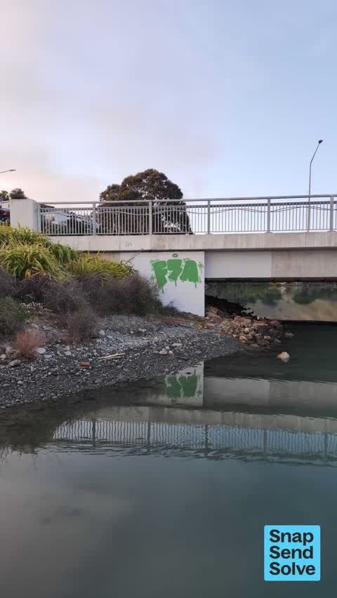
 Graffiti on a road, footpath or bridge —
 graffiti on side and under bridge
 Damaged Street Sign —
 signs have been run down
 Graffiti on a fence, building or structure —
 Also on the Sumner side of Ferrymead Bridge
- Road Signage —
St Andrews Hill Road name blade missing at Bridle Path Road intersection
- Road Signage —
Bridle Path Road name blade missing at Main Road intersection
 Graffiti on a fence, building or structure —
 Graffiti underneath Heathcote River bridge near Ferrymead.
 Roads - General —
 Urgent. Blocked road lane (fallen tree) bottom of St Andrews Hill
 Graffiti on a fence, building or structure —
 Graffiti has been sprayed on the cement section of the road. Can’t be seen from this angle, but it’s there.
 Graffiti on a fence, building or structure —
  Graffiti on a road, footpath or bridge —
 Graffiti under the Heathcote Bridge in Ferrymead, on the yacht club side.
 Graffiti somewhere else —
  Graffiti somewhere else —
 On electric box
 Graffiti somewhere else —
 Spray paint
 Graffiti somewhere else —
 Corner
- Street Light Outage —
Green light at the Ferrymead Bridge, in the direction towards Sumner, is out. The rest of the lights are working fine, it’s just that one.
 Roads - General —
 Green light out at traffic lights. Has been out for a couple days to a week.
 Damaged Road —
 Green light not working
 Road Signage —
 Green Light out
- Poles and Signage - General —
Kia ora, The city-facing green traffic signal light in the pedestrian refuge at the intersection of Bridle Path Road and Main Road (to Sumne
- Roads - General —
Straight ahead light on the island is out (and has been for the last week), at the Mt Pleasant end of this intersection. thanks
 Road Signage —
 Traffic light bulb out. The green ‘straight ahead light’ hasn’t been working for a few days now. The green arrow is working.
 Roads - General —
 This red light is out on the Ferrymead Bridge
- Roads - General —
Traffic lights are short changing on the turning right arrow into bridal path road from ferry road. Causing traffic to back up down Ferry R
- Graffiti —
- Graffiti —
- Damaged Street Sign —
- Road Blockage —
- Street Cleaning —
- Water Leak —
- Water Leak —
 Graffiti —
 Graffiti on ferrymead bridge
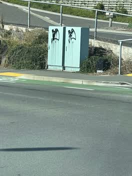 Graffiti —
 On cabinets near Ferrymead bridge at Bridle Path turning in Ferry Road.
- Roading/Streets —
No ramped on/off cycle access curb to the Coastal Pathway Cycle path from Bridal Path Rd. Forced to use the pedestrian ramped curb access. S
- Flooding —
Bridle Path Road flooded at intersection with St Andrews Hill Road.
Roading/Streets —
weeding needed :)
Graffiti —
Box behind fence. On cnr St.Andrews Hill rd
Graffiti —
Graffiti —
Also reported on Ferrymead Terrace
- 1 Ferrymead Terrace — 36 reports
- 5 Ferrymead Terrace — 20 reports
- 11 Ferrymead Terrace — 11 reports
- 7 Ferrymead Terrace — 3 reports
- 9 Ferrymead Terrace — 2 reports
The street’s crash record
NZTA’s record names Ferrymead Terrace in 5 crashes that hurt somebody since 2006 — 5 seriously hurt, nobody killed.
The green nearby
- Scott Park Ferrymead — 21 m to the edge · 2 ha
- Settlers Reserve — 115 m to the edge · 13 ha
- Te Awakura Reserve — 245 m to the edge
- Ferrymead Reserve — 348 m to the edge · Botanic · 1 ha
- The Brae — 381 m to the edge
Parks within half a kilometre, measured to the boundary — the council’s open data.
On the doorstep
- The Kebab King Ferrymead — 183 m away · Fast food
- Claddagh — 184 m away · Bars & pubs
- Anytime Fitness — 188 m away · Gyms & fitness
- Best Turkish Food Co. — 188 m away · Restaurants
Businesses within four hundred metres, measured at the pin — OpenStreetMap and the council directories.
The bus nearby
- Main Rd near St Andrews Hill Rd — 72 m away · route 3
- Main Rd near Te Awakura Tce — 186 m away · route 3
The closest Metro stops, within four hundred and fifty metres.
The tracks through here
- Walk and bike track through Ferrymead — 7 m to the line · walk · bike
- Walk and bike track through Ferrymead — 7 m to the line · walk · bike
- Walk and bike track through Ferrymead — 79 m to the line · walk · bike
- Walk and bike track through Ferrymead — 137 m to the line · walk · bike
- Walk and bike track through Ferrymead — 143 m to the line · walk · bike
Tracks whose line passes within half a kilometre, measured to the line itself — the council’s open data.
The named ground
Named water within 500 m of this address, measured to the line or the edge; the council’s own structure register — bridges, boardwalks and steps standing nearby — the open map’s record.
The remembered names nearby
- Christchurch / City Council / 1967 / H2o – S10 – T16 — 87 m away ·
CHRISTCHURCH / CITY COUNCIL / 1967 / H2O – S10 – T16
· 1998
Inscribed plaques within two hundred and fifty metres — the register’s pins, not surveyed spots. The whole roll is at /plaques.
What was here — Former Dwelling and Setting
74 m away · 2A Main Road · located to ±7 m · the place’s own record →
On the register. Nothing researched here yet.
The civic layer
This ground votes in Heathcote ward — the Spreydon-Cashmere-Heathcote community board. Ward lines don’t always follow suburb lines; this one is measured at the pin, not the suburb’s centre.
What stood on this ground → · On the map → · From the air — the Crown’s aerials back to 1936; search the address on RetroLens →
Questions, answered briefly
38 council reports on record since April 2019 — most often graffiti (7), roads - general (5), road signage (4).
Ferrymead, Christchurch — on Ferrymead Terrace.
The heritage register names a place at or beside it — Former Dwelling and Setting.
Scott Park Ferrymead — 21 m to its edge, 2 ha.