347A Halswell Road, Halswell
55 reports on record since September 2016 · 50 with photographs. The street’s heaviest record is 305 Halswell Road — 57 reports on file. Indicative rating valuation and school zones, hazards, bin day and what stood here before.
What gets reported here
- Graffiti — 15
- Park - General Request — 8
- Parks — 7
- Rubbish and Bins - General — 5
- Facility - General Request — 4
- Trees - General — 3
Photographed here 50 on record



Reported here
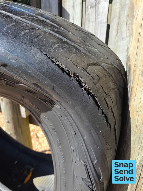
 Playground Equipment —
 worn tyre in playground with exposed steel braid.
 Rubbish and Bins - General —
 graffiti on an environ waste skip by a regular tagger around Halswell. Not sure if on rubbish skips anyone dares, but it looks unsightly
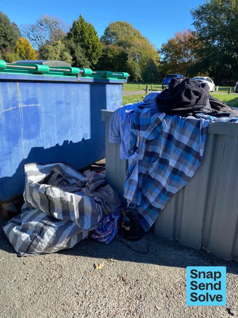
 Litter —
 Someone has dumped a whole lot of rubbish at Halswell football clubrooms that is not ours ?
 Facility - General Request —
 Bollard jammed so unable to lock
 Park - General Request —
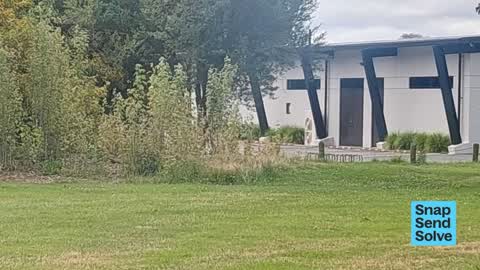
 Just wondering why the rest of the Domain has been mown but the part in front of the Kindergarten has been left. In the past this has alway
 Water Leak —
 Leaking ‘‘em next to soccer fields near club rooms and cricket practice nets
 Litter —
 Littered cans and bottles
 Rubbish and Bins - General —
 Disappointed that this mess is still here and the big belly bin has been broken?
 Rubbish and Bins - General —
 Tins and rubbish everywhere
 Dumped Rubbish —
 Dumped at our club not ours
 Overgrown Vegetation —
 The mowing if the Domain appears less frequent than it used to be and it has made the Domain less well maintained. While it looks like it wa
 Vandalism - General —
 Rubbish bin by the park. The catch to shut its is broken.
 Rubbish and Bins - General —
 Overflowing rubbish bin for a week. Thanks
 Rubbish and Bins - General —
 Bin needs emptying
 Trees - General —
  Dumped Rubbish —
 These were left outside our club Not ours
 Park - General Request —
 I was given a phone call by the Council in regards to this problem approximately 3-4 weeks ago as the last send snap solve request I sent, I
 Park - General Request —
 Hello there, this is the 4th time I’m writing in about this and every time I’ve written in, the problem is getting worse and worse. My send
 Park - General Request —
 This is the third time I’ve brought this up. Now there is a massive divot/hole in the ground because it seems like a vehicle has gone over t
 Park - General Request —
 The irrigation/drainage system still hasn’t been fixed
 Park - General Request —
 Seems like there’s a broken irrigation system at Halswell Domain, on the T1 football training pitch. Very boggy in one area of the pitch wh
 General Request —
 Damage to box by Light Tower, far left corner of tree line middle of football grounds
 Park - General Request —
 Halswell Domain T1 field, water sprinkler burst/flooding. Can be found on far sideline near the trees and halfway line
 Trees - General —
 Lots of branches down
 Overgrown Vegetation —
 Wind damage Halswell domain.
- Trees - General —
- Facility - General Request —
- Facility - General Request —
- Graffiti —
- Facility - General Request —
 Park - General Request —
 2m³ topsoil required
 Parks —
 please increase irrigation at Halswell Domain
Parks —
trees overhanging on Halswell domain football S2 (nearest swimming pool) can they be cut before season starts please?
Water Supply —
This hose was added to our external tap in December as a temporary measure. Just wondering when the issue will be fixed. It is a trip hazard
Parks —
sprinkler head hole on football field is dangerous and needs filling in. Halswell domain S4 south west end of goal box near model trains. m
Graffiti —
Graffiti on door at back of building
Parks —
abandoned cone
Graffiti —
hàlswell domain carpark by soccer club
Graffiti —
hàlswell domain soccer clubrooms
Parks —
moron riding motor bike through park. about 10 junior crocket yeams practicing
Rubbish/Recycling —
Rubbish hasn't been collected for some time
Parks —
branch down middle of touch field by cricket club
Graffiti —
halswell domain playground tagging. Reported by Jeff, logged by Sarah at Recreational Services
Graffiti —
Soccer club building defaced
Parks —
Can the disabled, no parking and keep clear (ambulance access) lines please be repainted
Graffiti —
Back of kindeegarten in domain
Graffiti —
Graffiti —
Graffiti —
Water Supply —
Unsure if large collection of water is coming from the council irrigation system. The water is coming up from the ground
Graffiti —
Graffiti —
Graffiti —
Behind rl clubrooms
Graffiti —
Behind halswell kindergarten
Graffiti —
Also reported on Halswell Road
- 305 Halswell Road — 57 reports
- 303 Halswell Road — 19 reports
- 346 Halswell Road — 17 reports
- 341 Halswell Road — 16 reports
- 514 Halswell Road — 15 reports
- 339 Halswell Road — 15 reports
- 301 Halswell Road — 14 reports
- 329 Halswell Road — 13 reports
The street’s crash record
NZTA’s record names Halswell Road in 32 crashes that hurt somebody since 2006 — 3 people killed, 6 seriously hurt.
The green nearby
- Halswell Domain — you are in it · Sports ground · 26 ha
- Cridland Drainage Reserve — 357 m to the edge
- Shield Reserve — 413 m to the edge
- Kinrara Reserve — 428 m to the edge
- John Olliver Reserve — 460 m to the edge · 2 ha
Parks within half a kilometre, measured to the boundary — the council’s open data.
The civic shelf nearby
- Halswell — 187 m away · Recreation centre · 339 Halswell Road
- Te Hāpua: Halswell Centre — 236 m away · Library · 341 Halswell Road, Halswell 8025
Libraries, halls and the rest within half a kilometre — the council’s open data.
On the doorstep
- Halswell Football Club — 16 m away · Sports centres
- Halswell Rugby League — 113 m away · Sports centres
- The Old Vicarage — 202 m away · Restaurants
- Halswell Bowling Club — 221 m away · Clubs
Businesses within four hundred metres, measured at the pin — OpenStreetMap and the council directories.
The bus nearby
- Halswell Rd near Nicholls Rd — 244 m away · route 100
- Halswell Rd near Nicholls Rd — 266 m away · route 100, route 125
The closest Metro stops, within four hundred and fifty metres.
The tracks through here
- Walk and bike track through Halswell — 248 m to the line · walk · bike
- Walk and bike track through Halswell — 449 m to the line · walk · bike
Tracks whose line passes within half a kilometre, measured to the line itself — the council’s open data.
The named ground
Named water within 500 m of this address, measured to the line or the edge; the council’s own structure register — bridges, boardwalks and steps standing nearby — the open map’s record.
The remembered names nearby
- Lions Club Halswell District — 85 m away ·
LIONS CLUB HALSWELL DISTRICT (logo marker)
· 2008 - H.R.F.L.C. / Halswell Rugby Football League Club — 127 m away ·
H.R.F.L.C. / Halswell Rugby Football League Club / (dedication text partly illegible) / 19
· 2013 - Edward Paterson Esq. Chairman 1909 — 165 m away ·
EDWARD PATERSON ESQ. CHAIRMAN 1909 — 19— (weathered)
· 2008
Inscribed plaques within two hundred and fifty metres — the register’s pins, not surveyed spots. The whole roll is at /plaques.
Renting nearby
new bonds in Halswell ran about $697 a week — $147 above the city median of $550 — the suburb page keeps the rent record →.
What was here — St Mary's Church Graveyard
122 m away · located to ±73 m · the place’s own record →
On the register. Nothing researched here yet.
What was here — St Mary's Church Lychgate and Setting
168 m away · located to ±3 m · the place’s own record →
On the register. Nothing researched here yet.
What was here — St Mary's Church and Setting
232 m away · located to ±14 m · the place’s own record →
On the register. Nothing researched here yet.
The civic layer
This ground votes in Halswell ward — the Halswell-Hornby-Riccarton community board. Ward lines don’t always follow suburb lines; this one is measured at the pin, not the suburb’s centre.
What stood on this ground → · On the map → · From the air — the Crown’s aerials back to 1936; search the address on RetroLens →
Questions, answered briefly
55 council reports on record since September 2016 — most often graffiti (15), park - general request (8), parks (7).
Halswell, Christchurch — on Halswell Road.
The heritage register names 3 places at or beside it — St Mary's Church Graveyard, St Mary's Church Lychgate and Setting.
Halswell Domain — the address is inside it, 26 ha.