10 Halswell Road, Hillmorton
16 reports on record since March 2022 · 12 with photographs. The street’s heaviest record is 37 Halswell Road — 52 reports on file. Indicative rating valuation and school zones, hazards, bin day and what stood here before.
What gets reported here
- Flooding — 4
- Pothole — 2
- Overgrown Vegetation — 2
- Water Leak — 1
- Street Gutters / Storm Water — 1
- Roading/Streets — 1
Photographed here 12 on record




Reported here
 Overgrown Vegetation —
 grass growing over bike path
 Graffiti on a fence, building or structure —
 graffiti
 Street Gutters / Storm Water —
 Gutter and drain blocked with grass, getting really muddy
 Water Leak —
 Burst water main?
 Graffiti on a traffic light pole or cabinet, or wa —
 Graffiti on pump cabinet
 Accessibility —
 I have stood at this intersection waiting to cross on the bike crossing. five cycles of traffic, no crossing. it is still red. accident
 Overgrown Vegetation —
 Grass growing over the path/bike lane. Narrowing the available space for passing dog walkers.
- Flooding —
Need to fix this asap on curlets rd. People are crossing double yellow lines to avoid it. Council just put flooding signs up.
- Flooding —
There is a blocked drain causing flooding to cover the southbound lane of traffic. This is making people go around to avoid it and making qu
 Flooding —
 Storm drains are blocked. Water flooding across road.
 Graffiti somewhere else —
 On electric boxes on corner of road
- Pothole —
Couple of pot holes. One major
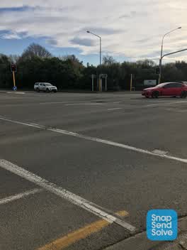 Pothole —
 - Flooding —
 Damaged Road —
 Massive pothole in the middle of the intersection
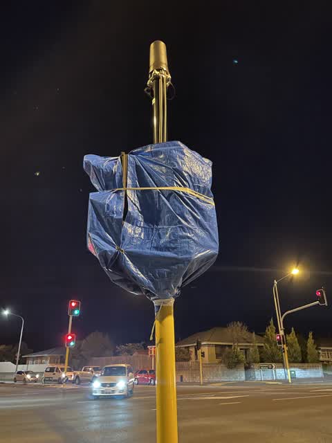
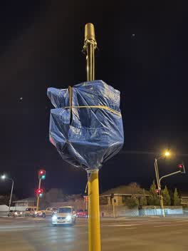 Roading/Streets —
 Cycling crossing lights have been covered off for months. When will it be opened?
Also reported on Halswell Road
- 37 Halswell Road — 52 reports
- 1 Halswell Road — 27 reports
- 2 Halswell Road — 24 reports
- 14 Halswell Road — 12 reports
- 52 Halswell Road — 11 reports
- 60 Halswell Road — 10 reports
- 112 Halswell Road — 10 reports
- 33 Halswell Road — 8 reports
The street’s crash record
NZTA’s record names Halswell Road in 33 crashes that hurt somebody since 2006 — 5 seriously hurt, nobody killed.
The green nearby
- Spreydon Riverbank Reserves — 189 m to the edge · 1 ha
- Sunnyside Heritage Garden — 225 m to the edge · Botanic · 1 ha
- Seager Park — 244 m to the edge · 3 ha
- Albion Reserve — 433 m to the edge
- Spreydon Domain — 445 m to the edge · Sports ground · 7 ha
Parks within half a kilometre, measured to the boundary — the council’s open data.
On the doorstep
- Cafe Ine — 74 m away · Cafés
- Hoon Hay Bakery and Café — 90 m away · Bakeries
- Wing Wah Takeaway — 101 m away · Fast food
- Michael’s Bakery — 125 m away · Bakeries
Businesses within four hundred metres, measured at the pin — OpenStreetMap and the council directories.
The bus nearby
The closest Metro stops, within four hundred and fifty metres.
The tracks through here
- Walk and bike track through Hillmorton — 31 m to the line · walk · bike
- Walk and bike track through Hillmorton — 31 m to the line · walk · bike
- Walk and bike track through Hillmorton — 31 m to the line · walk · bike
- Walk and bike track through Hillmorton — 74 m to the line · walk · bike
- Walk and bike track through Hillmorton — 218 m to the line · walk · bike
Tracks whose line passes within half a kilometre, measured to the line itself — the council’s open data.
The named ground
Named water within 500 m of this address, measured to the line or the edge; Named places within 1.5 km of this address; the council’s own structure register — bridges, boardwalks and steps standing nearby — the open map’s record.
Renting nearby
new bonds in Hillmorton ran about $590 a week — $40 above the city median of $550 — the suburb page keeps the rent record →.
The civic layer
This ground votes in Spreydon ward — the Spreydon-Cashmere-Heathcote community board. Ward lines don’t always follow suburb lines; this one is measured at the pin, not the suburb’s centre.
What stood on this ground → · On the map → · From the air — the Crown’s aerials back to 1936; search the address on RetroLens →
Questions, answered briefly
16 council reports on record since March 2022 — most often flooding (4), pothole (2), overgrown vegetation (2).
Hillmorton, Christchurch — on Halswell Road.
Nothing on the heritage register at this exact spot — the record around this ground →
Spreydon Riverbank Reserves — 189 m to its edge, 1 ha.