37 Halswell Road, Hillmorton
52 reports on record since June 2019 · 26 with photographs. The most-reported address on Halswell Road. Indicative rating valuation and school zones, hazards, bin day and what stood here before.
What gets reported here
- Graffiti — 11
- Pothole — 6
- Damaged Road — 5
- Roads - General — 3
- Overgrown Vegetation — 3
- Dumped Rubbish — 3
Photographed here 26 on record


Reported here
 Traffic Signals —
 Street and traffic lights out and dangerous
 Overgrown Vegetation —
 Curletts road / Lincoln road corner has some overgrown trees approaching the intersection which is blocking vision of signs
- Traffic Signals —
traffic lights times have changed causing flow of traffic to be a mess and big queues
 Graffiti on a traffic light pole or cabinet, or wa —
  Pavement - Damaged —
 Dip in path with raised paver - Tripping/Fallen Harzard.
 Water Leak —
 leaking water meter, toby lid off, water flowing under footpath, light pole sinking into saturated ground, asphalt sinking
 Rubbish and Bins - General —
 The lid on our red wheelie bin is broken. The lid might need replaced.
 Damaged Street Light —
 For nzta, street light outside 37 Halswell road is missing the protective glass that prevents birds etc from living inside of it. Lamp expos
 Overgrown Vegetation —
 Grass overgrown onto foot path by a foot in places on the hoon hay road street front of 37 Halswell road
 Graffiti on a bus stop or public toilet —
 Graffiti on timetable and over the bus stop itself.
 Dumped Rubbish —
  Dumped Rubbish —
 On corner closest to 37 Halswell road
- Flooding —
Flooding covering the whole left hand lane heading from Curletts road to hoon hay road. Quite severe.
 Graffiti on a cabinet, pole or railway asset —
 Graffiti on traffic light control box
 Graffiti on a cabinet, pole or railway asset —
 Graffiti on cabinet at intersection
 Graffiti somewhere else —
 Tall blue cabinet graffiti
 Rubbish and Bins - General —
 Ours and neighbours recycling bins missed Tuesday collection day.
 Graffiti —
  Graffiti —
  Graffiti —
 Traffic control box
 Pest / Vermin —
 I frequently see rats when walking past this hedge by Barrington Park in Barrington St. There is a lot of rubbish under the hedge. The rats
 Graffiti —
 It is located right on the intersection
 Overgrown Vegetation —
 Corner of Barrington Street andWychburyStBermnevermowed Rental property
- Graffiti —
- Graffiti —
- Noise - Construction —
- Vandalism - General —
- Roads - General —
- Damaged Road —
- Water General —
- Damaged Road —
- Roads - General —
- Street Cleaning —
- Pavement - Damaged —
- Roads - General —
- Damaged Road —
- Pothole —
- Pothole —
- Damaged Road —
- Pothole —
- Pothole —
- Pothole —
- Pothole —
- Damaged Road —
- Dumped Rubbish —
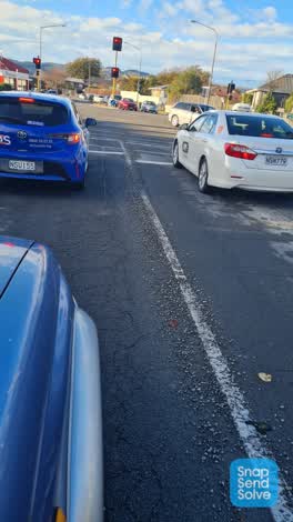 Roading/Streets —
 Gravel and broken glass across street and the intersection making for a hazard for turning vehicles and cycles.
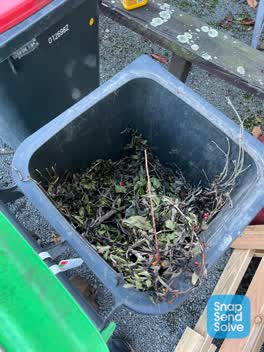 Rubbish/Recycling —
 Bins not fully empty. Green bin has been half emptied and has label on it. Red bin was half emptied and no note. Remaining stuff in green bi
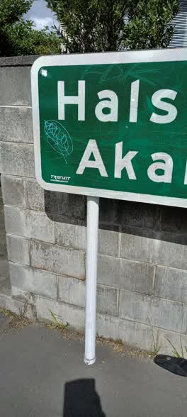 Graffiti —
 37 Halswell Rd - multiple Graffiti on Halswell/Akaroa destination sign on footpath boundary
Graffiti —
Graffiti —
on road sign pointing down Hoon Hay road
- Graffiti —
on the sign at the Halswell Curletts corner on the centre plot towards Middleton
- Graffiti —
on the sign at the Halswell Curletts corner on the centre plot towards Middleton
Also reported on Halswell Road
- 1 Halswell Road — 27 reports
- 2 Halswell Road — 24 reports
- 10 Halswell Road — 16 reports
- 14 Halswell Road — 12 reports
- 52 Halswell Road — 11 reports
- 60 Halswell Road — 10 reports
- 112 Halswell Road — 10 reports
- 33 Halswell Road — 8 reports
The street’s crash record
NZTA’s record names Halswell Road in 33 crashes that hurt somebody since 2006 — 5 seriously hurt, nobody killed.
The green nearby
- Spreydon Riverbank Reserves — 204 m to the edge · 1 ha
- Sunnyside Heritage Garden — 241 m to the edge · Botanic · 1 ha
- Seager Park — 271 m to the edge · 3 ha
- Spreydon Domain — 425 m to the edge · Sports ground · 7 ha
- Albion Reserve — 458 m to the edge
Parks within half a kilometre, measured to the boundary — the council’s open data.
On the doorstep
- Cafe Ine — 66 m away · Cafés
- Hoon Hay Bakery and Café — 76 m away · Bakeries
- Wing Wah Takeaway — 88 m away · Fast food
- Michael's at Hillmorton Bakery — 115 m away · Business
Businesses within four hundred metres, measured at the pin — OpenStreetMap and the council directories.
The bus nearby
The closest Metro stops, within four hundred and fifty metres.
The tracks through here
- Walk and bike track through Hillmorton — 1 m to the line · walk · bike
- Walk and bike track through Hillmorton — 9 m to the line · walk · bike
- Walk and bike track through Hillmorton — 9 m to the line · walk · bike
- Walk and bike track through Hillmorton — 78 m to the line · walk · bike
- Walk and bike track through Hillmorton — 231 m to the line · walk · bike
Tracks whose line passes within half a kilometre, measured to the line itself — the council’s open data.
The named ground
Named water within 500 m of this address, measured to the line or the edge; Named places within 1.5 km of this address; the council’s own structure register — bridges, boardwalks and steps standing nearby — the open map’s record.
Renting nearby
new bonds in Hillmorton ran about $590 a week — $40 above the city median of $550 — the suburb page keeps the rent record →.
The civic layer
This ground votes in Spreydon ward — the Spreydon-Cashmere-Heathcote community board. Ward lines don’t always follow suburb lines; this one is measured at the pin, not the suburb’s centre.
What stood on this ground → · On the map → · From the air — the Crown’s aerials back to 1936; search the address on RetroLens →
Questions, answered briefly
52 council reports on record since June 2019 — most often graffiti (11), pothole (6), damaged road (5).
Hillmorton, Christchurch — on Halswell Road.
Nothing on the heritage register at this exact spot — the record around this ground →
Spreydon Riverbank Reserves — 204 m to its edge, 1 ha.