2 Halswell Road, Hillmorton
24 reports on record since September 2018 · 18 with photographs. The street’s heaviest record is 37 Halswell Road — 52 reports on file. Indicative rating valuation and school zones, hazards, bin day and what stood here before.
What gets reported here
Photographed here 18 on record


Reported here
 Graffiti on a playground or in a park —
 Tagging on… This thing?
 Graffiti on a fence, building or structure —
 Tagged street light (fence, building or structure)
 Pavement - General —
 26 months of total neglect. Narrow and dangerous for pedestrians when confronted with an electric bike travelling at speed.
 Pavement - General —
 This shared cycleway walkway starting at Halswall road is not to council minimum recommended width. It is barely a metre wide in places.
 Graffiti on a bus stop or public toilet —
 Graffiti on bus stop
- Graffiti on a bus stop or public toilet —
Bus stop opposite Coppell Place, Hillmorton
 Graffiti on a traffic light pole or cabinet, or wa —
 Tag on cabinet
 Pavement - Damaged —
 Failing pothole and developing pothole
 Fallen Tree —
 Very large Tree fallen from heathcote river onto Southern Health School
 Overgrown Vegetation —
 Vine weed overtaking area along bike/pedestrian path next to stream
 Overgrown Vegetation —
 Grass is over growing the shared path
 General Request —
 There has been for the past 7 days now a small tent set up next to the walkway along the left e of Annex Road off Lincoln Road. From time to
 Pavement - Damaged —
 The bike path in this stretch has lots of cracking and bumps that are difficult to spot and could cause an accident
- Graffiti —
- Vandalism - General —
- Fallen Tree —
- Overgrown Vegetation —
- Overgrown Vegetation —
 Street Light Outage —
 Right filter green not working. No right turn phase into Curletts. Forcing traffic to cross on red phase. Sat through three cycles of lights
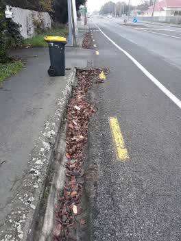 Roading/Streets —
 hi, this gutter needs clearing please. last time l used this app to advise about this piece of gutter it took 6 months to get sorted. Maybe
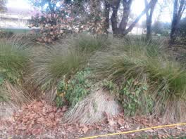 Parks —
 convolvulous growing throughout park
Water Leak —
looks like a car hit a rpz
Roading/Streets —
Very low overhanging branches from oak tree across the footpath near the end of Annex Road where it meets Lincoln Road.
Graffiti —
Both sides of black wall
Also reported on Halswell Road
- 37 Halswell Road — 52 reports
- 1 Halswell Road — 27 reports
- 10 Halswell Road — 16 reports
- 14 Halswell Road — 12 reports
- 52 Halswell Road — 11 reports
- 60 Halswell Road — 10 reports
- 112 Halswell Road — 10 reports
- 33 Halswell Road — 8 reports
The street’s crash record
NZTA’s record names Halswell Road in 33 crashes that hurt somebody since 2006 — 5 seriously hurt, nobody killed.
The green nearby
- Spreydon Riverbank Reserves — 78 m to the edge · 1 ha
- Sunnyside Heritage Garden — 114 m to the edge · Botanic · 1 ha
- Seager Park — 160 m to the edge · 3 ha
- Albion Reserve — 333 m to the edge
- Pavilion Park — 385 m to the edge
Parks within half a kilometre, measured to the boundary — the council’s open data.
On the doorstep
- Hillmed Health Centre — 87 m away · Doctors & clinics
- Tasty Pizza — 87 m away · Fast food
- Cafe Ine — 95 m away · Cafés
- Sushi Ball House — 98 m away · Fast food
Businesses within four hundred metres, measured at the pin — OpenStreetMap and the council directories.
The bus nearby
The closest Metro stops, within four hundred and fifty metres.
The tracks through here
- Walk and bike track through Hillmorton — 66 m to the line · walk · bike
- Walk and bike track through Hillmorton — 107 m to the line · walk · bike
- Walk and bike track through Hillmorton — 123 m to the line · walk · bike
- Walk and bike track through Hillmorton — 123 m to the line · walk · bike
- Walk and bike track through Hillmorton — 166 m to the line · walk · bike
Tracks whose line passes within half a kilometre, measured to the line itself — the council’s open data.
The named ground
Named water within 500 m of this address, measured to the line or the edge; Named places within 1.5 km of this address; the council’s own structure register — bridges, boardwalks and steps standing nearby — the open map’s record.
Renting nearby
new bonds in Hillmorton ran about $590 a week — $40 above the city median of $550 — the suburb page keeps the rent record →.
The civic layer
This ground votes in Spreydon ward — the Spreydon-Cashmere-Heathcote community board. Ward lines don’t always follow suburb lines; this one is measured at the pin, not the suburb’s centre.
What stood on this ground → · On the map → · From the air — the Crown’s aerials back to 1936; search the address on RetroLens →
Questions, answered briefly
24 council reports on record since September 2018 — most often overgrown vegetation (4), roading/streets (2), pavement - general (2).
Hillmorton, Christchurch — on Halswell Road.
Nothing on the heritage register at this exact spot — the record around this ground →
Spreydon Riverbank Reserves — 78 m to its edge, 1 ha.