116–198 Curletts Road
7 council reports since August 2025, 7 carrying a photograph. The street’s heaviest record is 102 Curletts Road, 21 reports on file.
On the register here
From the air, then
Sourced from Canterbury Maps and partners. RNZAF, CC BY 3.0 NZ. Each frame is cut from Environment Canterbury’s historic imagery MapServer for that decade, only where the Footprints layer names a CC BY survey (NZAM-covered spots stay out). RetroLens holds more Crown aerials →
The green nearby
- Canterbury Agricultural Park, 25 m to the edge · Sports ground · 42 ha
- Seager Park, 236 m to the edge · 3 ha · playground, 19 pieces
- Nga Puna Wai, 375 m to the edge · Sports ground · 83 ha · playground, 4 pieces
- Mokihi Reserve, 402 m to the edge
- Marylands Reserve, 476 m to the edge · Sports ground · 6 ha
Parks within half a kilometre, measured to the boundary, the council’s open data. The whole roll is at /parks.
The tracks through here
- Walk and bike track through Hillmorton, 376 m to the line · walk · bike
- Walk and bike track through Hillmorton, 384 m to the line · walk · bike
- Walk and bike track through Hillmorton, 405 m to the line · walk · bike
- Walk and bike track through Hillmorton, 429 m to the line · walk · bike
- Walk and bike track through Hillmorton, 481 m to the line · walk · bike
Tracks whose line passes within half a kilometre, the council’s open data.
The named ground
Named water within 500 m of this address, measured to the line or the edge; Named places within 1.5 km of this address; the council’s own structure register, bridges, boardwalks and steps standing nearby, the open map’s record.
The remembered names nearby
- Canterbury Agricultural Park / Was Officially, 241 m away ·
CANTERBURY AGRICULTURAL PARK / WAS OFFICIALLY OPENED BY THE / GOVERNOR GENERAL / SIR MICHA
· 2018 - Unveiled 11‑11‑1987 by / T.M.R. Maskew O.B.E. Past President, 242 m away ·
UNVEILED 11‑11‑1987 BY / T.M.R. MASKEW O.B.E. PAST PRESIDENT / TO MARK / 125 YEARS OF SHOW
· 2018 - Unveiled 16‑11‑2012, 242 m away ·
UNVEILED 16‑11‑2012 BY / THEIR ROYAL HIGHNESSES PRINCE CHARLES / AND THE DUCHESS OF CORNWA
· 2018
Inscribed plaques within two hundred and fifty metres, the register’s pins, not surveyed spots. The whole roll is at /plaques.
Renting nearby
new bonds in Hillmorton ran about $590 a week, $40 above the city median of $550, the suburb page keeps the rent record →.
What gets reported here
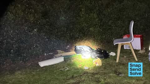
Photographed here 7 on record


What’s on record
 Dumped Rubbish, 14 Jul 2026
Pile of trash
 Pavement - Damaged, 17 Jun 2026
Yet more pavement damage. Please fix.
 Graffiti on a road, footpath or bridge, 20 Jan 2026
behind the speed sign.
 Graffiti on a sign, mural or public art, 20 Jan 2026
6 x graffiti scrawls
 Road Signage, 20 Jan 2026
Been there since November
 Graffiti on a sign, mural or public art, 26 Nov 2025
Graffiti on road sign
 Overgrown Vegetation, 5 Aug 2025
Grass clippings from mowing are on shared path. They get wet+icey, causing some pretty slick conditions..
Elsewhere on Curletts Road
- 102 Curletts Road, 21 reports
- 102f Curletts Road, 17 reports
- 300 Curletts Road, 16 reports
- 102a Curletts Road, 5 reports
- 200–284 Curletts Road, 3 reports
- 102c Curletts Road, 3 reports
- 102e Curletts Road, 2 reports
- 102d Curletts Road, 2 reports
The street’s crash record
NZTA’s record names Curletts Road in 33 crashes that hurt somebody since 2006, 4 seriously hurt, nobody killed.
The civic layer
This ground votes in Halswell ward, the Halswell-Hornby-Riccarton community board is its local layer. Ward lines don’t always follow suburb lines; this one is measured at the pin, not the suburb’s centre. The whole roll is at /wards.
Curletts Road, the whole record → · Everything about Hillmorton → · What stood on this ground → · On the map → · From the air, RetroLens holds the Crown’s aerials back to 1936; search the address there →
Questions, answered briefly
7 council reports on record since August 2025, most often graffiti on a sign, mural or public art (2), road signage (1), pavement - damaged (1).
Hillmorton, Christchurch, on Curletts Road.
The heritage register names a place at or beside it, Former A & P Showgrounds Treasurer's Building and Setting.
Canterbury Agricultural Park, 25 m to its edge, 42 ha.