96 Clyde Road, Ilam
18 reports on record since March 2023 · 9 with photographs. The street’s heaviest record is 43 Clyde Road, 36 reports on file. Indicative rating valuation and school zones, hazards, bin day and what stood here before.
What gets reported here
Photographed here 9 on record


Reported here
- Damaged Road,
roadworks have left this intersection in fully unacceptable and unsafe condition for cyclists. too much loose gravel and it's obscuring bump
 Street Cleaning,
 many of the Flexi posts to protect cycle lanes at this intersection are broken or bent (just about every corner), and lots of scree in the c
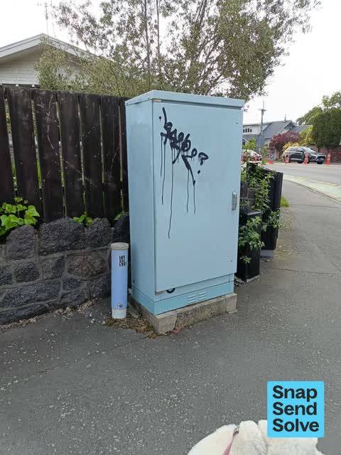
 Graffiti on a traffic light pole or cabinet, or wa,
 - Traffic Signals,
Traffic lights are not phased to accommodate all the additional traffic heading towards the university or trying to right turn from Kotare
 Damaged Street Sign,
 The plastic wands at this intersection are either missing, or damaged and lean into the cycleway itself. This creates a hazard. Please remed
 Poles and Signage - General,
 Blocked cycle lane due to broken pole. Dangerous for cyclists.
 Graffiti on a fence, building or structure,
 Graffiti on the other side of the box. I can't stop there as it's traffic lights. Opposite Medbury School.
- Roads - General,
The Dormer site on Clyde road has had a huge impact on traffic management. Traffic travelling past the uni towards Creyke road has been move
 Graffiti on a cabinet, pole or railway asset,
 Traffic control
 Graffiti somewhere else,
 Another traffic control box hit!
 Graffiti somewhere else,
  Graffiti somewhere else,
 - Roads - General,
- Roads - General,
- Roads - General,
- Roads - General,
- Damaged Road,
- Damaged Road,
Also reported on Clyde Road
- 43 Clyde Road, 36 reports
- 56 Clyde Road, 19 reports
- 54 Clyde Road, 11 reports
- 31 Clyde Road, 11 reports
- 75 Clyde Road, 9 reports
- 50A Clyde Road, 9 reports
- 48 Clyde Road, 8 reports
- 46 Clyde Road, 8 reports
From the air, then
Sourced from Canterbury Maps and partners. LINZ, CC BY 3.0 NZ. Each frame is cut from Environment Canterbury’s historic imagery MapServer for that decade, only where the Footprints layer names a CC BY survey (NZAM-covered spots stay out). RetroLens holds more Crown aerials →
The street’s crash record
NZTA’s record names Clyde Road in 76 crashes that hurt somebody since 2006, 10 seriously hurt, nobody killed.
The green nearby
- Fendalton Park, 188 m to the edge · Sports ground · 5 ha
Parks within half a kilometre, measured to the boundary, the council’s open data.
On the doorstep
- ESR, 218 m away · Research
- Fendalton Bowling Club, 331 m away · Sports centres
- Fendalton Park Croquet Club, 365 m away · Sports centres
- BP Connect, 379 m away · Dairies & convenience
Businesses within four hundred metres, measured at the pin: OpenStreetMap and the council directories.
The bus nearby
The closest Metro stops, within four hundred and fifty metres.
The tracks through here
- Walk and bike track through Ilam, 3 m to the line · walk · bike
- Walk and bike track through Ilam, 8 m to the line · walk · bike
- Walk and bike track through Ilam, 9 m to the line · walk · bike
- Walk and bike track through Ilam, 212 m to the line · walk · bike
- Walk and bike track through Ilam, 262 m to the line · walk · bike
Tracks whose line passes within half a kilometre, measured to the line itself, the council’s open data.
The named ground
Named water within 500 m of this address, measured to the line or the edge; Named places within 1.5 km of this address; the council’s own structure register, bridges, boardwalks and steps standing nearby, the open map’s record.
Renting nearby
new bonds in Ilam ran about $548 a week, about the city median, the suburb page keeps the rent record →.
What was here, Dwelling and Setting
162 m away · located to ±25 m · the place’s own record →
On the register. Nothing researched here yet.
What was here, Dwelling and Setting, Kooringa
193 m away · 88A Clyde Road · located to ±21 m · the place’s own record →
On the register. Nothing researched here yet.
What was here, Dwelling and Setting, Avonhoe
193 m away · 4 Medbury Terrace · located to ±14 m · the place’s own record →
On the register. Nothing researched here yet.
What was here, Dwelling and Setting
198 m away · 83 Clyde Road · located to ±19 m · the place’s own record →
On the register. Nothing researched here yet.
The civic layer
This ground votes in Fendalton ward, the Fendalton-Waimairi-Harewood community board. Ward lines don’t always follow suburb lines; this one is measured at the pin, not the suburb’s centre.
What stood on this ground → · On the map → · From the air, the Crown’s aerials back to 1936; search the address on RetroLens →
Questions, answered briefly
18 council reports on record since March 2023, most often roads - general (5), graffiti somewhere else (3), damaged road (3).
Ilam, Christchurch, on Clyde Road.
The heritage register names 4 places at or beside it, Dwelling and Setting, Dwelling and Setting, Kooringa.
Fendalton Park, 188 m to its edge, 5 ha.