7 Francis Avenue, Mairehau
14 reports on record since December 2021 · 12 with photographs. The most-reported address on Francis Avenue. Indicative rating valuation and school zones, hazards, bin day and what stood here before.
What gets reported here
- Water Leak — 3
- Flooding — 3
- Street Gutters / Storm Water — 2
- Graffiti — 2
- Roading/Streets — 1
- Road Signage — 1
Photographed here 12 on record


Reported here
 Street Gutters / Storm Water —
 Storm water drain heating is blocked by vegetation
 Animal - Domestic —
 Poultry farm at 29 Warrington st. I counted 16 chickens and could hear more.
 Flooding —
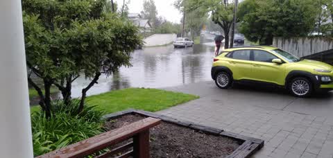
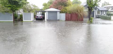
 Road flooding with very little rain. Outlet drain bubbling Appears blocked
 Water Leak —
 Tap at boundary does not turn off totally. We are relevelling so need it to stop fully.
 Flooding —
 Drain Blocked again flooding my garage and my neighbours
 Road Signage —
 Signs left and not collected
 Street Gutters / Storm Water —
 Plastic sheet locking drain grate
 Graffiti —
  Water Leak —
 Water leak major
- Water Leak —
- Graffiti —
 Damaged Road —
 Judder bar broken already.
 Flooding —
 Flooding again. Needs street closed to stop wash from cars
 Roading/Streets —
 Culvit between number 7 and 11 Francis avenue was overflowing. This end of the street was flooded and cars driving thru made it even worse.
Also reported on Francis Avenue
- 10 Francis Avenue — 9 reports
- 19 Francis Avenue — 7 reports
- 8 Francis Avenue — 6 reports
- 67 Francis Avenue — 6 reports
- 3 Francis Avenue — 6 reports
- 21 Francis Avenue — 6 reports
- 11 Francis Avenue — 6 reports
- 26 Francis Avenue — 4 reports
The street’s crash record
NZTA’s record names Francis Avenue in 3 crashes that hurt somebody since 2006 — 0 seriously hurt, nobody killed.
The green nearby
- St Albans Park — 136 m to the edge · Sports ground · 6 ha
- Berwick Reserve — 313 m to the edge
Parks within half a kilometre, measured to the boundary — the council’s open data.
On the doorstep
- King's Books & Stamps — 135 m away · Bookshops
- Kin Kin — 145 m away · Restaurants
- Kin Kin South East Asian Takeaway — 147 m away · Restaurants
- Vape Centre — 151 m away · E Cigarette
Businesses within four hundred metres, measured at the pin — OpenStreetMap and the council directories.
The bus nearby
- Flockton St near Carrick St — 153 m away · route 44
- Flockton St near Carrick St — 166 m away · route 44
The closest Metro stops, within four hundred and fifty metres.
The tracks through here
- Walk and bike track through Mairehau — 137 m to the line · walk · bike
- Walk and bike track through Mairehau — 471 m to the line · walk · bike
Tracks whose line passes within half a kilometre, measured to the line itself — the council’s open data.
The named ground
Named water within 500 m of this address, measured to the line or the edge; the council’s own structure register — bridges, boardwalks and steps standing nearby — the open map’s record.
Renting nearby
new bonds in Mairehau ran about $409 a week — $141 below the city median of $550 — the suburb page keeps the rent record →.
The civic layer
This ground votes in Innes ward — the Papanui-Innes-Central community board. Ward lines don’t always follow suburb lines; this one is measured at the pin, not the suburb’s centre.
What stood on this ground → · On the map → · From the air — the Crown’s aerials back to 1936; search the address on RetroLens →
Questions, answered briefly
14 council reports on record since December 2021 — most often water leak (3), flooding (3), street gutters / storm water (2).
Mairehau, Christchurch — on Francis Avenue.
Nothing on the heritage register at this exact spot — the record around this ground →
St Albans Park — 136 m to its edge, 6 ha.