
Water Leak257 Hills Road
water leaking down foot path at front corner of property between 255 and 257 Hills road, Mairehau chch.
6,743 council reports since June 2015, the 19th busiest suburb in the city. 5,353 photographs on record. 7,100 people at the 2023 Census, 1,568 to the square kilometre across 4.5 km².
The record also holds about $409 a week to rent· 2023 Census snapshot· 5,353 photographs· 1 school· 11 parks· 3 places of worship· 18 tracks· 5 names on the map· 28.5% of the outline mapped liquefied· graded mostly TC2 in 2011· the record drew water over 39% of the outline· high flood hazard over 9% of the outline· noise overlays over 72% of the outline· setback strips over 7% of the outline· 7% of the outline inside the plan’s density overlays· 2,710 SCIRT photographs filed on this ground· 22.5 km of cycleway crosses the outline· 1 remembered name on this ground· 5 drawn rules bind this ground· 10 parcels on the dangerous-work register· 127 parcels of made ground· 7 parcels with a cleanup on file· the 2019 model grades this ground mostly medium· 16 council structures on the register· 34 recreation register records· 1,656 trees on the register· the plan’s word on this ground· 23% of the outline reserved· 269 injury crashes· 1,664 recorded victimisations· 32 bus stops· 38 businesses· the council’s fix times· 40 documents· 5 mentions on the wire
Link-outs to the source’s own live pages, chch.live does not copy their live values or source text.
New bonds here ran at about $409 a week in the April–June 2026 quarter, the middle half of them between $397 and $618, across 63 bonds lodged, down 15% on a year ago. That’s about $141 a week below the city’s own quarter median of $550. Tenancy Services counts these under the Mairehau North and Mairehau South areas combined, approximately this suburb.
Median and quartiles of weekly rents on new private bonds, by quarter; suburb figures are a bond-weighted blend of the areas. New bonds are fresh lodgements, not the whole rental stock; under five bonds the rent is withheld, and counts are randomly rounded. Source: Tenancy Services rental bond data: provisional while the bond system migrates.
The ground: the February 2011 survey drew liquefaction over 28% of it; the 2011 grading filed it mostly TC2, the rest of the watch is drawn further down.
Day to day it holds 1 school, 11 parks, 3 places of worship, 18 tracks and 32 bus stops, each is counted further down.
Lately the record’s mostly graffiti & vandalism, 933 reports in the year to 12 October 2026, the newest 11 October 2026.
One for the quiz, Its busiest day on record was 21 April 2016, 57 reports in a single day.
About 7,053 people and 2,670 occupied private households in the “Mairehau North”, “Northcote (Christchurch City)” and “Mairehau South” areas, grouped from 46 SA1 areas. Several statistical areas are combined here, so this is a grouped proxy rather than a count for one suburb boundary.
Ethnicity is a multiple-response measure, so those percentages are not meant to add to 100%.
Stats NZ’s 2023 Census uses fixed random rounding to base 3. Unavailable or confidential cells are left out, not treated as zero. individuals · households · geography · CC BY 4.0.
Mairehau is a suburb of Christchurch, New Zealand. It is located 4 kilometres north of the city centre, close to the edge of the urbanised central city area. Much new development is being carried out on the northern edge of Mairehau.
water leaking down foot path at front corner of property between 255 and 257 Hills road, Mairehau chch.


Dry conditions with a wet spot on the field at Macfarlane park possibly irrigation issue


The water backs up along the gutter here all the time. It’s been beautiful weather and the rest of the road is free from water except this area. The grass here…
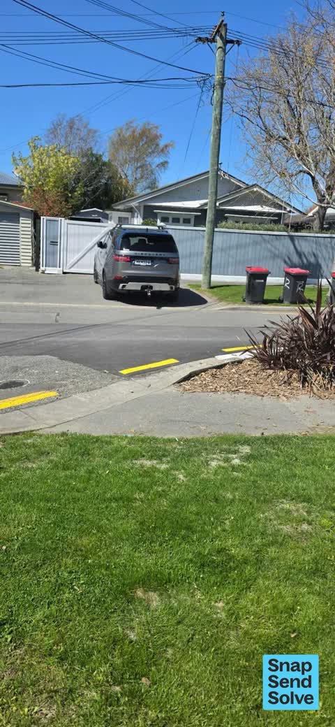
MKM324. This lady parks over the footpath every day. All day every day her car is parked there. It’s very annoying, I walk my baby in the pram down here and I…

Large Green bin has a large crack down the back. Serial 668852. Paid for through Waste Management but assume can be asked to be replaced through here.

The median council work order pinned in Mairehau took 3 days to resolve, about the city-wide median (3 days). The slowest tenth waited 3 months or longer. 295 tickets are open here now, the oldest was filed 31 December 2018.
Work orders, not the resident reports above, the council’s MyCouncilTicket stream, and one job can appear in both. A median counts only finished jobs; open ones are named as open, never averaged in. The ticket roll · the whole city’s fix times.
4 sensitive sites stand here, Mairehau High School, Mairehau Primary School, St Francis of Assisi Catholic School, Te Hiwa Shirley Primary School, and the Local Alcohol Policy restricts new off-licences within 200 m of them.
The council’s bylaw zones and the Local Alcohol Policy’s buffer list, read from the Regulatory open-data service. A ban rules drinking in public places; it says nothing about whether a premises may sell, that is the licence register’s job.
Zoned for Christchurch Adventist School · Emmanuel Christian School · Mairehau High School · Marian College · Middleton Grange School · St Bede's College · and 11 more zones, the drawn zone is indicative; the Ministry’s written scheme is the legal boundary.
Decile and EQI describe the community a school draws from, not how well it teaches.
The first eight of 11, Parks and reserves in the council’s open data, a park lands in the suburb its centre falls inside. The whole roll is at /parks.
Places of worship in the open map’s record, one lands in the suburb its building stands in. The whole roll is at /worship.
The first eight of 18, Tracks in the council’s open data, a line belongs to every suburb it passes through. The whole network is at /tracks.
The February 2011 survey drew mapped ground failure over 28.5% of this outline, about 129 hectares. A patch is a footprint, not a finding about an address; the count for the whole city is at /liquefaction.
The 2011 grading filed 77.9% of this outline, about 353 hectares, mostly TC2. A graded area files under the suburb its middle sits in, and a category is a verdict for a patch of ground, not a finding about an address; the grades are drawn at /technical-categories.
The flood record drew water over 38.9% of this outline, about 176 hectares, across 2 named events. A patch is one event’s observation, not a live hazard finding; the whole record is drawn at /floods.
10 parcels inside this outline sit on the hazardous-activities register, mostly chemical manufacture, application and bulk storage, cemeteries and waste recycling, treatment and disposal, vehicle refuelling, service and repair, 1 still doing the work. A listing records the work, not a soil test; the whole register is drawn at /hazards.
The files record 127 parcels of made or characterised ground inside this outline, about 40 hectares, mostly silt, topsoil, mixed fill with rubbish, 9 carry fill the file can’t vouch for. A record is the file’s word on what was laid, not a fresh survey; the whole layer is drawn at /fill.
7 parcels inside this outline carry a cleanup on the file, 1 marked verified. A cleanup on the file is the register’s word, not a clearance; the whole register is drawn at /remediated.
The 2019 liquefaction study put 51% of this outline in the medium class, and 3 assessed areas here carry the free-face flag for possible lateral spreading. A class is the model’s verdict on a patch of ground, not a finding about an address; the whole study is drawn at /vulnerability.
The council’s structure register stands 16 assets on this ground, 6 bridges, 5 sets of steps, 4 ramps, 1 viewing platform, sited at Macfarlane Park, Westminster Park, Bullers Drainage Reserve, Mairehau Public Library. The register’s site names are its own labels for the ground an asset stands in; the layer is drawn at the map.
The recreation register keeps 34 records inside this outline, bookable surfaces for 7 football, 7 touch rugby, 7 softball, 6 rugby. Seasons and surfaces are the register’s record, not this week’s draw; the layer is drawn at the map.
The register counts 1,656 living trees inside this outline, 6 veterans among them, 39 carrying a protection, mostly Manna Ash, Ash, Scarlet Oak. The file remembers 751 trees felled here. A tree record is the register’s word on what stands or stood; the whole canopy is drawn at /trees.
The plan files 42% of this outline under Residential Suburban, 57% residential, the rest mostly Transport 19%, Rural Urban Fringe 16%. A zone is a permission, not a description, the mix is read from a sampled join of the plan’s polygons; the whole district is drawn at /zones.
The plan reserves about 103 hectares of this outline, 23%, under 11 designations, mostly pipes, movement, learning. A designation is a claim on the ground, not a build date, the mix is read from a sampled join; the whole register is drawn at /designations.
The plan’s flood map draws 9% of this outline inside high flood hazard ground, about 42 hectares across 6 mapped areas. The broader flood-management watch covers 65% of it, Avon River, Dudley Creek, Lower Styx River. 5 ponding spots are mapped here, where the models expect water to sit. Shares read from a sampled join; a model’s map, not a promise. The waiting water is drawn at /flood-hazard.
The plan’s noise overlays cover 72% of this outline, about 325 hectares across 1 mapped overlay, and inside the airport’s bird-strike buffer. Shares read from a sampled join; a planning line, not a meter’s reading. The quiet lines are drawn at /noise.
The plan’s water-margin layers cross this outline, 173 classified reaches, the plan calling Dudley Creek and Winters Road Drain by name, 7% of it inside the setback strips, the widest holding 10 m off the bank. The margin is the plan’s drawing, not a survey of the bank; the reaches, strips and held edges are mapped at /water-margin.
The plan’s allowed shape holds this outline, 7% of it inside the residential overlays, the densest standing Suburban Density Transition. The shape is the plan’s permission, not a survey of what stands; the allowed shape is drawn at /density.
The rebuild’s cameras filed 2,710 photographs on this ground, 2001–2017, wastewater work mostly. Each frame is a receipt the dig left behind, a work log, not a survey of what stands now; the whole record is drawn at /rebuild.
The pedal network threads this ground, 22.5 km of cycleway crosses the outline. A segment counts under every suburb its path enters; the whole network is drawn at /cycleways.
The remembered names stand on this ground, 1 inscribed plaque, Walter Park among the grounds. The plaque is the register’s pin, not a surveyed spot; the whole roll is kept at /plaques.
The rulebook binds this ground, 5 drawn instruments, 5 bottle-store buffers; the outline sits inside the takiwā of Te Ngai Tuahuriri Runanga. The bylaw is the instrument, this the map of it, the whole rulebook is drawn at /rules.
The named waterways, bays, headlands, monuments, summits and old sites OpenStreetMap puts inside this outline, a pin is the mapper’s own; a waterway belongs to every suburb it crosses. Every roll, counted: /geography.
269 crashes that hurt somebody on record inside Mairehau's outline, 4 people killed, 44 seriously hurt.
The corner that keeps appearing: Innes Road at Mahars Road, 19 injury crashes.
1,664 victimisations on the Police record inside Mairehau’s outline, September 2022–August 2026, mostly theft, about 59 a year per 1,000 residents. Up 3% on the year before. Reported is not all, how much never reaches the record depends on the offence.
32 Metro stops inside Mairehau's outline, in ECan’s stop record, served by route 44, the Orbiter (anticlockwise), the Orbiter (clockwise), route 100, route 7.
38 premises in Mairehau across 19 kinds, from OpenStreetMap, the council’s licensed-premises register and its 2024 Find Christchurch directory. Each kind below opens at this suburb’s shelf.
Among them, the ones the record says most about:
What the archive’s sources say about Mairehau, titled for it, turned up by a search for one of its places, or carrying its name in the text. These are leads and citations: the originals live at the provider, linked from each row.
…urday mdonalda examination has been comj pleted in connection with the horowhenua i biook mairehau an old chief of the muanpoko who was present at many fights on the biook is now giving evidence chris…Hawke's Bay Herald · Papers Past · National Library of New Zealand · · text held
…to the platform followed by sir j g ward and the royal party the mayor and mrs rhodes and mairehau rhodes presented the duchess with a haaidsome shower bouquet in violefts messrs gf g stead h f wigram…Star · Papers Past · National Library of New Zealand · · text held
…t 31b 3 zalso started kohina bst 91b puketapu 7st 91b moreen 7st blb flying shell 7st tib mairehau 6st 91b time imin 18 3-ssec dividends 4 and 1 4s 6d morton memorial stakes of 60 soys one mile fair j…Evening Post · Papers Past · National Library of New Zealand · · text held
…le convoy on his running in the maiden was best backed for the scurry and won all the way mairehau also by vanguard was well backed but finished in the nick jenkins mount explorer a three-year-old fli…Otago Witness · Papers Past · National Library of New Zealand · · text held
…s heroru by the artistmona 9st harris 1 62 mr a peter aldinga pritchard 2 103 mr o c lett mairehau walden 3 also ran77 adonis 146 hardgraf t 125 european g8 welicnsa 19 vega 30 baumai loe-jreto 23 rar…Manawatu Standard · Papers Past · National Library of New Zealand · · text held
…i 2 hardwork 3 won by a nose dividends 4 17s and 7 18s farewell scurry keneru 1 aldinga 2 mairehau 3 won by half a length dividends 7 15s and 3 15s reefton races reefton december 27 flying handicap cr…Otago Witness · Papers Past · National Library of New Zealand · · text held
…ess 7st 111 b flying shell 7st 101 b prisoner 7st 101 b etena 7st 71b liquidation 7st 71b mairehau 7st 71b toledo 7st 71b anchorite 7st 71b werekino 7st 71b xjilnochie 7st 71b waireka 7st 71b impati 7…Evening Post · Papers Past · National Library of New Zealand · · text held
…3 scratched laures and roseplot time lmin 27sec dividends 1 19s and 1 5s 6d maiden plate mairehau 1 kuseioto 2 levant 3 all started won easily time 2mm 2 2-ssec dividends 2 7s 6d and 1 17s kawakawa h…Otago Witness · Papers Past · National Library of New Zealand · · text held
…d lusestina could not catch him the taranam contingent had a big win over p keith charges mairehau and anchorite on the first day and it is said that the latter connections had 300 on the kecluse mare…Evening Post · Papers Past · National Library of New Zealand · · text held
…1013 cobra 1011 plain stone 10 5 old gun 99 romany lad 99 tyrone 9 9 clarion 99 rocket 93 mairehau 93 thorwn 93 dairy lane 93 mftnfatera 92 last hope 90 master model 90 hautana 90 hunters steeples 3 m…Auckland Star · Papers Past · National Library of New Zealand · · text held
The rest are a search away, the whole shelf, for the name →
Compare Mairehau with Shirley · Edgeware · Saint Albans · Richmond · Dallington · Merivale, same record, side by side.
Mairehau is a suburb of Christchurch, New Zealand. The public record holds 6,743 council reports for it, the first filed in June 2015.
7,100 people at the 2023 Census, 1,568 per square kilometre across 4.5 km².
About 7,053 people and 2,670 occupied private households (combined SA2s): grouped from Stats NZ SA1 areas through this site’s suburb join. Indicative, not a LIM.
6,743 reports on record, most often graffiti & vandalism (1,856), water & drains (1,325), roads & footpaths (1,242). 933 of them in the year to 12 October 2026.
269 injury crashes on the police record inside the suburb’s outline, 4 people killed, 44 seriously hurt. The suburb’s crashes, mapped →
The 2011 technical categories filed 77.9% of the suburb’s outline, about 353 hectares, mostly TC2. TC1 meant standard foundations sufficed, TC2 enhanced, TC3 site-specific engineering, a verdict for the patch of ground, not a finding about any one address. The grades, drawn →
Every suburb in Christchurch → · Its decade, charted → · the whole A–Z →
Work orders, not the resident reports above, the council’s MyCouncilTicket stream, and one job can appear in both. A median counts only finished jobs; open ones are named as open, never averaged in. The ticket roll · the whole city’s fix times.
The council’s bylaw zones and the Local Alcohol Policy’s buffer list, read from the Regulatory open-data service. A ban rules drinking in public places; it says nothing about whether a premises may sell, that is the licence register’s job.
Ministry of Education directory, the final decile and the current Equity Index describe the community a school draws from, not how well it teaches. Zones are indicative; the written enrolment scheme rules.
Parks and reserves in the council’s open data, the park lands in the suburb its centre falls inside; one that straddles the line keeps its own address.
Libraries, halls, cemeteries and the rest in the council’s open data, a facility lands in the suburb its point or centre falls inside.
Places of worship in the open map’s record, one lands in the suburb its building stands in. The whole roll is at /worship.
Marae in the region’s roll, a marae stands where it stands; the join names the suburb the roll files it under. The whole roll is at /maraes.
Walking, biking, horse and off-road tracks in the council’s open data, a line belongs to every suburb it passes through.
OpenStreetMap’s own record, inside this outline, a pin is the mapper’s; a waterway belongs to every suburb it crosses. Every roll, counted: /geography.
Heritage places the council’s district plan or Heritage New Zealand list inside this suburb, each with what is known about it and the document it is known from.
The register’s era records for places in this suburb, what stood on the ground, and when.
Each of these is a decade of reports, the heritage places on the register, what is known about them, and the documents behind it, everything the archive holds about the part of the city it names.