176 Papanui Road, Merivale
16 reports on record since June 2020 · 16 with photographs. The street’s heaviest record is 258 Papanui Road — 37 reports on file. Indicative rating valuation and school zones, hazards, bin day and what stood here before.
What gets reported here
Photographed here 16 on record


Reported here
 Street Gutters / Storm Water —
 Missing drain cover on northeast corner of papanui road and St Albans Street.
 Water Leak —
 Water leak continues to get worse behind 176 Papanui road. Now flooding to the water meter. This has been ongoing for at least 5 days now. T
 Water Leak —
 Rear of 176 Papanui Road, water bubbling up from water mains, been happening since at least Saturday.
 Graffiti on a cabinet, pole or railway asset —
  Graffiti somewhere else —
 176 Papanui Rd - traffic light control box
 Graffiti on a cabinet, pole or railway asset —
 The traffic control box has been badly graffitied
 Graffiti somewhere else —
  Road Signage —
 Green bulb light on traffic light is out
 Pavement - General —
 Hello Council Person The water from the downpipe is spilling onto the footpath, due to the drain being blocked. Could consideration be gi
 Damaged Street Sign —
 Hello council person, This issue has yet to be addressed and it's quite important. I wonder if you could look into the matter? Thanks
 Damaged Street Sign —
 Hello Council Person Someone hit this pole about five days ago the good thing is somebody has put a orange cone identifying the hazard. Coul
 Hazard — vehicle —
 Parking is allowed on St. Albans street too close to the intersection at Papanui. It makes creates a bottleneck on St. Albans resulting in 3
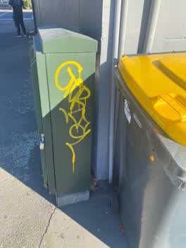 Graffiti —
 Could consideration be given to removing this tag? ??
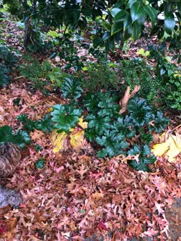 Parks —
 Please spray these noxious plants b4 they take over the garden. Thx
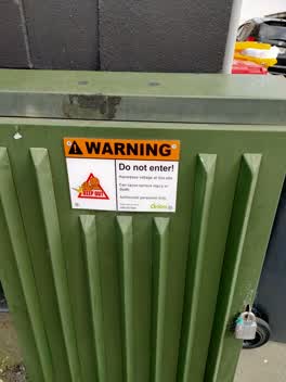 Graffiti —
 orion cabinet
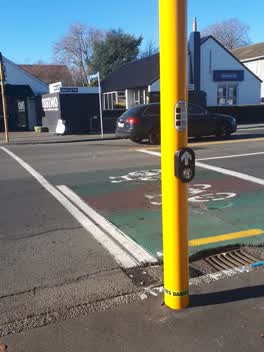 Roading/Streets —
 call box not working on crossing
Also reported on Papanui Road
- 258 Papanui Road — 37 reports
- 165 Papanui Road — 18 reports
- 1 Papanui Road — 17 reports
- 27 Papanui Road — 15 reports
- 177 Papanui Road — 15 reports
- 175 Papanui Road — 14 reports
- 71 Papanui Road — 12 reports
- 79E Papanui Road — 11 reports
The street’s crash record
NZTA’s record names Papanui Road in 160 crashes that hurt somebody since 2006 — 27 seriously hurt, nobody killed.
The green nearby
- Merivale Village Green — 17 m to the edge
Parks within half a kilometre, measured to the boundary — the council’s open data.
On the doorstep
- Expression Tattoo Studio — 7 m away · Tattoo & piercing
- Satchmo — 14 m away · Hairdressers
- Frogmore — 15 m away · Gift shops
- Merivale Tailoring Alterations — 16 m away · Tailors
Businesses within four hundred metres, measured at the pin — OpenStreetMap and the council directories.
The bus nearby
- Papanui Rd near Rugby St — 67 m away · route 1, route 95
- Papanui Rd near St Albans St — 96 m away · route 1, route 95
The closest Metro stops, within four hundred and fifty metres.
The named ground
Named water within 500 m of this address, measured to the line or the edge — the open map’s record.
The remembered names nearby
- Donated by the Merivale Precinct Society to Commemorate — 49 m away ·
DONATED BY THE MERIVALE PRECINCT SOCIETY TO COMMEMORATE THEIR 21ST ANNIVERSARY IN 1991
· 2006
Inscribed plaques within two hundred and fifty metres — the register’s pins, not surveyed spots. The whole roll is at /plaques.
Renting nearby
new bonds in Merivale ran about $604 a week — $54 above the city median of $550 — the suburb page keeps the rent record →.
What was here — Dwelling and Setting, Amwell
98 m away · 166 Papanui Road · located to ±16 m · the place’s own record →
On the register. Nothing researched here yet.
What was here — Dwelling and Setting, Long Cottage
122 m away · 10/142 Rugby Street · located to ±15 m · the place’s own record →
On the register. Nothing researched here yet.
What was here — Dwelling and Setting, Orana
154 m away · 146 Papanui Road · located to ±18 m · the place’s own record →
On the register. Nothing researched here yet.
What was here — Former St Albans Automatic Telephone Exchange and Setting
157 m away · 29 St Albans Street · located to ±25 m · the place’s own record →
On the register. Nothing researched here yet.
The civic layer
This ground votes in Fendalton ward — the Fendalton-Waimairi-Harewood community board. Ward lines don’t always follow suburb lines; this one is measured at the pin, not the suburb’s centre.
What stood on this ground → · On the map → · From the air — the Crown’s aerials back to 1936; search the address on RetroLens →
Questions, answered briefly
16 council reports on record since June 2020 — most often water leak (2), graffiti somewhere else (2), graffiti on a cabinet, pole or railway asset (2).
Merivale, Christchurch — on Papanui Road.
The heritage register names 4 places at or beside it — Dwelling and Setting, Amwell, Dwelling and Setting, Long Cottage.
Merivale Village Green — 17 m to its edge.