258 Papanui Road, Merivale
37 reports on record since April 2021 · 28 with photographs. The most-reported address on Papanui Road. Indicative rating valuation and school zones, hazards, bin day and what stood here before.
What gets reported here
Photographed here 28 on record


Reported here
 Graffiti on a fence, building or structure —
 Graffiti on light pole
 Traffic Signals —
 Faulty pedestrian crossing button on number 8 post. You need to push the button multiple times for it to activate the ‘don’t cross’ on pole
- Traffic Signals —
Traffic today is heavy and NW- bound right-turning traffic into Innes Road is clogged by absence of RH green arrow - should be there. i wait
 Traffic Signals —
 These lights have been bad for about a month. Sometimes only letting out 3 cars west or eastbound. The queues on Heaton Street/Innes road ar
- Traffic Signals —
Green arrow for turning right at heaton st is not working. This is from papanui street, and is the St George's corner
 Overgrown Vegetation —
 Bush overhanging at lights and it is a busy route for people going to school
 Damaged Street Sign —
 Traffic information sign is kaput
 Traffic Signals —
 Right hand traffic signal on Heaton street side is covered up with a blue cover making it impossible to see in daytime and hard to see at ni
 Traffic Signals —
 This traffic light has been covered for many months. It makes it very hard to navigate the intersection if you are heading into town, along
- Traffic Signals —
City bound lane on Papanui has had lights on right hand side covered for months. Makes it difficult when turning right down Heaton as have t
 Roads - General —
 This traffic light shown in the picture is working, however is covered by a blue cover and is causing difficulty for drivers trying to know
 Graffiti somewhere else —
 White utility box next to traffic signals control box at Innes road and Papanui Rd
 Poles and Signage - General —
 Traffic light was covered from road works over 6 months ago. Roadworks have been completed but traffic light is still covered and should may
 Graffiti on a cabinet, pole or railway asset —
  Poles and Signage - General —
 Traffic lights on corner or Heaton St and Papanui Road not functioning. Has been covered in blue tarpauline for 3 months or more. No right t
 Roads - General —
 Missing valve hole cover
 Graffiti somewhere else —
  Graffiti somewhere else —
 I think one of these boxes relates to the traffic lights but sorry not sure
- Road Signage —
Traffic light Heaton st side is covered up with blue cover so unable to see lights on that side
 Street Cleaning —
 Glass on road
 Poles and Signage - General —
 This set of traffic lights has been broken and covered for over four weeks. It is dangerous, especially at night because you can't even see
 Road Signage —
 Traffic lights red and orange are not working. Green is.
 Pothole —
 Slumped surface (again). Original contractor needs to be held to account for failure of compacted fill.
 Road Signage —
 This sign stopped working many months ago
 Poles and Signage - General —
 There is no right turn arrow from Papanui road onto Innes road. This creates an enormous back up of traffic and results in 1-2 cars being ab
- Overgrown Vegetation —
- Street Cleaning —
- Graffiti —
- Roads - General —
 General Request —
  Graffiti —
  Graffiti —
 Purple paint tag on this padlocked asset on the corner of Heaton Street and Papanui Road.
 Water Leak —
 Its a river
 Dumped Rubbish —
 Emptyish Hydrochloric acid container behind tree on Southwest CNR of intersection
- Roading/Streets —
There are traffic light filters for innes rd but none for Papanui rd. Isn't it time given the traffic congestion, that traffic light filters
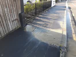 Water Leak —
 BIG water leak.... Papanui road. Cnr Heaton and Papanui.... (East bound Papanui).
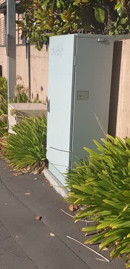 Graffiti —
 traffic signals box? innes rd Papanui Rd
Also reported on Papanui Road
- 165 Papanui Road — 18 reports
- 1 Papanui Road — 17 reports
- 176 Papanui Road — 16 reports
- 27 Papanui Road — 15 reports
- 177 Papanui Road — 15 reports
- 175 Papanui Road — 14 reports
- 71 Papanui Road — 12 reports
- 79E Papanui Road — 11 reports
The street’s crash record
NZTA’s record names Papanui Road in 160 crashes that hurt somebody since 2006 — 27 seriously hurt, nobody killed.
The green nearby
- Elmwood Park — 459 m to the edge · Sports ground · 7 ha
- Merivale Village Green — 492 m to the edge
Parks within half a kilometre, measured to the boundary — the council’s open data.
On the doorstep
- Bradley Wood Dentists — 42 m away · Dentists
- Georgio's Cafe @ St Georges Hospital — 54 m away · Cafés
- Intus Specialist Health Care — 75 m away · Doctors & clinics
- Ru&Co Hair Spa — 82 m away · Hairdressers
Businesses within four hundred metres, measured at the pin — OpenStreetMap and the council directories.
The bus nearby
- Papanui Rd near Milford St — 48 m away · route 1, route 95, route 100
- Papanui Rd near Heaton St — 63 m away · route 1, route 95
The closest Metro stops, within four hundred and fifty metres.
The tracks through here
- Walk and bike track through Merivale — 8 m to the line · walk · bike
- Walk and bike track through Merivale — 464 m to the line · walk · bike
Tracks whose line passes within half a kilometre, measured to the line itself — the council’s open data.
The named ground
Named water within 500 m of this address, measured to the line or the edge — the open map’s record.
Renting nearby
new bonds in Merivale ran about $604 a week — $54 above the city median of $550 — the suburb page keeps the rent record →.
What was here — Dwelling and Setting
137 m away · 236 Papanui Road · located to ±19 m · the place’s own record →
On the register. Nothing researched here yet.
What was here — Dwelling and Setting, Damsels
166 m away · 283 Papanui Road · located to ±22 m · the place’s own record →
On the register. Nothing researched here yet.
What was here — Dwelling and Setting, Cobham
237 m away · 35 Knowles Street · located to ±14 m · the place’s own record →
On the register. Nothing researched here yet.
The civic layer
This ground votes in Fendalton ward — the Fendalton-Waimairi-Harewood community board. Ward lines don’t always follow suburb lines; this one is measured at the pin, not the suburb’s centre.
What stood on this ground → · On the map → · From the air — the Crown’s aerials back to 1936; search the address on RetroLens →
Questions, answered briefly
37 council reports on record since April 2021 — most often traffic signals (7), poles and signage - general (4), graffiti (4).
Merivale, Christchurch — on Papanui Road.
The heritage register names 3 places at or beside it — Dwelling and Setting, Dwelling and Setting, Damsels.
Elmwood Park — 459 m to its edge, 7 ha.