16 Te Awakura Terrace
5 council reports since May 2018, 3 carrying a photograph. The street’s heaviest record is 1 Te Awakura Terrace, 15 reports on file.
On the register here
- Former Dwelling and Setting, 2A Main Road (193m)
From the air, then
Sourced from Canterbury Maps and partners. RNZAF, CC BY 3.0 NZ. Each frame is cut from Environment Canterbury’s historic imagery MapServer for that decade, only where the Footprints layer names a CC BY survey (NZAM-covered spots stay out). RetroLens holds more Crown aerials →
The green nearby
- Scott Park Ferrymead, 99 m to the edge · 2 ha
- Te Awakura Reserve, 113 m to the edge
- The Brae, 145 m to the edge
- King Park, 301 m to the edge · 2 ha · playground, 10 pieces
- Settlers Reserve, 371 m to the edge · 13 ha
Parks within half a kilometre, measured to the boundary, the council’s open data. The whole roll is at /parks.
The bus nearby
- St Andrews Hill Rd near The Brae, 66 m away · route 140
- St Andrews Hill Rd near The Brae, 81 m away · route 140
The closest Metro stops, within four hundred and fifty metres.
The tracks through here
- Walk and bike track through Mount Pleasant, 89 m to the line · walk · bike
- Walk and bike track through Mount Pleasant, 89 m to the line · walk · bike
- Walk and bike track through Mount Pleasant, 147 m to the line · walk · bike
- Walk and bike track through Mount Pleasant, 368 m to the line · walk · bike
- Walk and bike track through Mount Pleasant, 382 m to the line · walk · bike
Tracks whose line passes within half a kilometre, the council’s open data.
The named ground
Named water within 500 m of this address, measured to the line or the edge; the council’s own structure register, bridges, boardwalks and steps standing nearby, the open map’s record.
The remembered names nearby
- Jonathan McGregor Smith / on Mt. D’Archiac, 201 m away ·
JONATHAN McGREGOR SMITH / on Mt. D’Archiac / May 6th 1955 – June 1st 2003 / Grandson of Ro
· 2009
Inscribed plaques within two hundred and fifty metres, the register’s pins, not surveyed spots. The whole roll is at /plaques.
Renting nearby
new bonds in Mount Pleasant ran about $700 a week, $150 above the city median of $550, the suburb page keeps the rent record →.
What gets reported here
Photographed here 3 on record


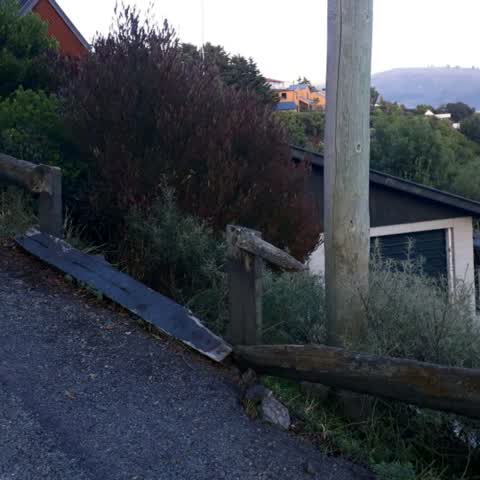
What’s on record
 Poles and Signage - General, 11 Apr 2025
 Job 1345171 I have already reported this but photos attached. The bollard and sign are blocking access to our driveway.
 Street Gutters / Storm Water, 21 Jul 2024
 Someone has illegally chopped down trees on our property and dumped the branches in the stormwater drain on our property. They have also den
- Water General, 14 Nov 2023
- Road Signage, 22 Dec 2022
Roading/Streets, 2 May 2018
Please fix the railings outside of my house which are council owned. They are a hazard due to the steep drop off. I have already reported th
Elsewhere on Te Awakura Terrace
- 1 Te Awakura Terrace, 15 reports
- 53 Te Awakura Terrace, 7 reports
- 51 Te Awakura Terrace, 4 reports
- 39 Te Awakura Terrace, 4 reports
- 37 Te Awakura Terrace, 4 reports
- 10 Te Awakura Terrace, 4 reports
- 65 Te Awakura Terrace, 3 reports
- 63 Te Awakura Terrace, 3 reports
The street’s crash record
NZTA’s record names Te Awakura Terrace in 3 crashes that hurt somebody since 2006, 0 seriously hurt, nobody killed.
The civic layer
This ground votes in Heathcote ward, the Spreydon-Cashmere-Heathcote community board is its local layer. Ward lines don’t always follow suburb lines; this one is measured at the pin, not the suburb’s centre. The whole roll is at /wards.
Te Awakura Terrace, the whole record → · Everything about Mount Pleasant → · What stood on this ground → · On the map → · From the air, RetroLens holds the Crown’s aerials back to 1936; search the address there →
Questions, answered briefly
5 council reports on record since May 2018, most often water general (1), street gutters / storm water (1), roading/streets (1).
Mount Pleasant, Christchurch, on Te Awakura Terrace.
The heritage register names a place at or beside it, Former Dwelling and Setting.
Scott Park Ferrymead, 99 m to its edge, 2 ha.