35B Collingwood Street, New Brighton
17 reports on record since March 2022 · 5 with photographs. The most-reported address on Collingwood Street. Indicative rating valuation and school zones, hazards, bin day and what stood here before.
What gets reported here
Photographed here 5 on record


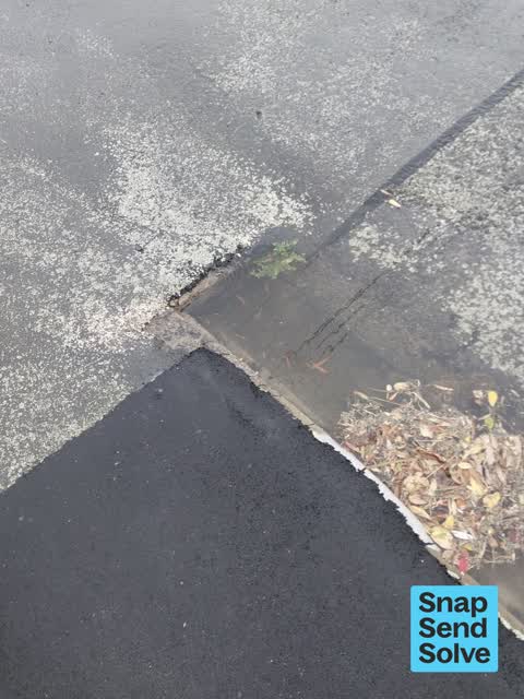

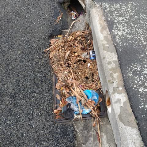
Reported here
 Street Gutters / Storm Water —
 stagnant smelly water blocked drain. supposedly repaired last year. this water has been sitting here since Monday
 Flooding —
 Stagnant mouldy water sitting for 12 days. Smelly and unhygienic
 Pit and Equipment - General —
 Oh dear the drains are blocked AGAIN. I must live on the eastern side of the city
- Pavement - General —
- Pavement - General —
- Street Gutters / Storm Water —
- Water Pollution - Sediment —
- Street Gutters / Storm Water —
- Pavement - Damaged —
- Street Gutters / Storm Water —
- Pavement - Damaged —
- Pit and Equipment - General —
- Pit and Equipment - General —
- Pavement - Damaged —
- Pit and Equipment - General —
 Flooding —
 This shows the water bubbling out of the ground and it's blowing the manhole out. All the curbs lead to that single drain and it's not handl
 Roading/Streets —
 This unsightly mess outside
Also reported on Collingwood Street
- 35 Collingwood Street — 11 reports
- 55 Collingwood Street — 10 reports
- 10 Collingwood Street — 9 reports
- 9 Collingwood Street — 6 reports
- 62A Collingwood Street — 3 reports
- 48 Collingwood Street — 3 reports
- 60 Collingwood Street — 2 reports
- 58 Collingwood Street — 2 reports
The green nearby
- Withells Island Reserve — 94 m to the edge · 4 ha
- New Brighton Mall Playground — 429 m to the edge
- Blighs Garden — 462 m to the edge · 6 ha
Parks within half a kilometre, measured to the boundary — the council’s open data.
On the doorstep
- Dogwatch Variety Shop — 147 m away · Variety Store
- New Brighton Museum — 149 m away · Museums
- Henry's Takeaways — 168 m away · Fast food
- Storer Motors — 180 m away · Car dealers
Businesses within four hundred metres, measured at the pin — OpenStreetMap and the council directories.
The bus nearby
- Hardy St near Beresford St — 158 m away · route 5, route 110
- Hardy St near Beresford St — 160 m away · route 5, route 110
The closest Metro stops, within four hundred and fifty metres.
The tracks through here
- Walk and bike track through New Brighton — 100 m to the line · walk · bike
- Walk and bike track through New Brighton — 130 m to the line · walk · bike
- Walk and bike track through New Brighton — 164 m to the line · walk · bike
- Walk and bike track through New Brighton — 315 m to the line · walk · bike
- Walk and bike track through New Brighton — 375 m to the line · walk · bike
Tracks whose line passes within half a kilometre, measured to the line itself — the council’s open data.
The named ground
Named water within 500 m of this address, measured to the line or the edge; Named places within 1.5 km of this address; the council’s own structure register — bridges, boardwalks and steps standing nearby — the open map’s record.
The remembered names nearby
- In Memory of / Deceased Members — 165 m away ·
IN MEMORY OF / DECEASED MEMBERS OF THE / LIONESS CLUB OF PEGASUS
· 2018
Inscribed plaques within two hundred and fifty metres — the register’s pins, not surveyed spots. The whole roll is at /plaques.
Renting nearby
new bonds in New Brighton ran about $520 a week — $30 below the city median of $550 — the suburb page keeps the rent record →.
The civic layer
This ground votes in Coastal ward — the Coastal-Burwood-Linwood community board. Ward lines don’t always follow suburb lines; this one is measured at the pin, not the suburb’s centre.
What stood on this ground → · On the map → · From the air — the Crown’s aerials back to 1936; search the address on RetroLens →
Questions, answered briefly
17 council reports on record since March 2022 — most often street gutters / storm water (4), pit and equipment - general (4), pavement - damaged (3).
New Brighton, Christchurch — on Collingwood Street.
Nothing on the heritage register at this exact spot — the record around this ground →
Withells Island Reserve — 94 m to its edge, 4 ha.