1 Cholmondeley Avenue, Opawa
17 reports on record since December 2019 · 14 with photographs. The street’s heaviest record is 22 Cholmondeley Avenue — 37 reports on file. Indicative rating valuation and school zones, hazards, bin day and what stood here before.
What gets reported here
- Fallen Tree — 6
- Dumped Rubbish — 4
- Rubbish/Recycling — 2
- Graffiti — 2
- Sewer - Leak / Blockage — 1
- Flooding — 1
Photographed here 14 on record


Reported here
 Flooding —
 Heathcote River opposite 182 Riverlaw Terrace Saint Martins Christchurch
 Fallen Tree —
 Branches in river
 Dumped Rubbish —
 dumped rubbish
 Dumped Rubbish —
  Dumped Rubbish —
 Big pile of rubbish dumped just north of Cholmondeley Ave on Fifield Tce beside the river
 Dumped Rubbish —
 Dumped bedding by the river bank
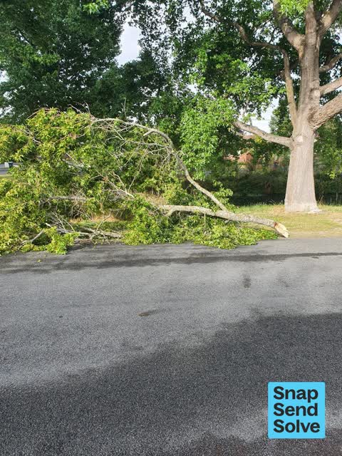
 Fallen Tree —
 Large broken branch fallen on road verge. Location is on riverbank side of Fifield Tce near end of Cholmondely Ave.
 Fallen Tree —
 Large branch has come down. Partially blocking the road.
 Fallen Tree —
 Broken tree limbs
 Fallen Tree —
 Somewhat dangerous on road
 Fallen Tree —
 Tree branch down and on the road slightly
- Graffiti —
- Damaged Street Sign —
- Graffiti —
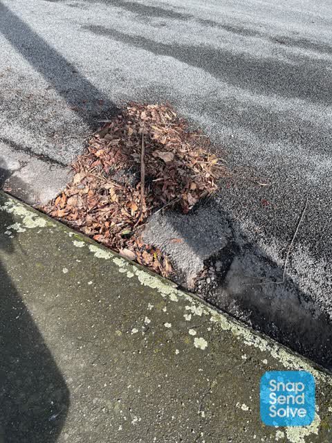
 Sewer - Leak / Blockage —
 Leaf blockage to gutter & drain site
Rubbish/Recycling —
This sodden mattress was dumped against the electrical substation in mid-December outside 123 Fifield Tce. It's still there.
Rubbish/Recycling —
Car petrol tank,swingball pole and maybe a piece from a TV,dumped on riverbank across the road from the house address.
Also reported on Cholmondeley Avenue
- 22 Cholmondeley Avenue — 37 reports
- 26A Cholmondeley Avenue — 9 reports
- 20 Cholmondeley Avenue — 8 reports
- 40 Cholmondeley Avenue — 4 reports
- 30 Cholmondeley Avenue — 4 reports
- 34 Cholmondeley Avenue — 3 reports
- 5 Cholmondeley Avenue — 2 reports
- 48 Cholmondeley Avenue — 2 reports
The street’s crash record
NZTA’s record names Cholmondeley Avenue in 1 crash that hurt somebody since 2006 — 0 seriously hurt, nobody killed.
The green nearby
- Risingholme Park — 56 m to the edge · Botanic · 2 ha
- Acorn Reserve — 200 m to the edge
- Fifield Reserve — 393 m to the edge
Parks within half a kilometre, measured to the boundary — the council’s open data.
On the doorstep
- Opawa Tennis — 92 m away · Sports centres
Businesses within four hundred metres, measured at the pin — OpenStreetMap and the council directories.
The bus nearby
- St Martins Rd near Ensors Rd — 136 m away · the Orbiter (clockwise)
- St Martins Rd near Ensors Rd — 154 m away · the Orbiter (anticlockwise)
The closest Metro stops, within four hundred and fifty metres.
The tracks through here
- Walk and bike track through Opawa — 1 m to the line · walk · bike
- Walk and bike track through Opawa — 33 m to the line · walk · bike
- Walk and bike track through Opawa — 142 m to the line · walk · bike
- Walk and bike track through Opawa — 159 m to the line · walk · bike
- Walk and bike track through Opawa — 165 m to the line · walk · bike
Tracks whose line passes within half a kilometre, measured to the line itself — the council’s open data.
The named ground
Named water within 500 m of this address, measured to the line or the edge; the council’s own structure register — bridges, boardwalks and steps standing nearby — the open map’s record.
The remembered names nearby
- J. R. McKenzie Gave Risingholme to This City 1943 — 85 m away ·
J. R. McKENZIE GAVE RISINGHOLME TO THIS CITY 1943
· 2009 - Officially Opened by E. H. Andrews, Mayor Chairman — 90 m away ·
OFFICIALLY OPENED BY E. H. ANDREWS, MAYOR CHAIRMAN OF RESERVES COMMITTEE J. N. CLARKE NOV
· 2009 - Risingholme Community Centre Inc. 1944 — 1994 This Plaque — 100 m away ·
RISINGHOLME COMMUNITY CENTRE INC. 1944 — 1994 This plaque was unveiled by Vicki Buck, Mayo
· 2009
Inscribed plaques within two hundred and fifty metres — the register’s pins, not surveyed spots. The whole roll is at /plaques.
Renting nearby
new bonds in Opawa ran about $555 a week — about the city median — the suburb page keeps the rent record →.
What was here — Former Dwelling and Setting, Risingholme
147 m away · 22 Cholmondeley Avenue · located to ±17 m · the place’s own record →
On the register. Nothing researched here yet.
What was here — 9 Ford Road
186 m away · 9 Ford Road · located to ±14 m · the place’s own record →
On the register. Nothing researched here yet.
The civic layer
This ground votes in Heathcote ward — the Spreydon-Cashmere-Heathcote community board. Ward lines don’t always follow suburb lines; this one is measured at the pin, not the suburb’s centre.
What stood on this ground → · On the map → · From the air — the Crown’s aerials back to 1936; search the address on RetroLens →
Questions, answered briefly
17 council reports on record since December 2019 — most often fallen tree (6), dumped rubbish (4), rubbish/recycling (2).
Opawa, Christchurch — on Cholmondeley Avenue.
The heritage register names 2 places at or beside it — Former Dwelling and Setting, Risingholme, 9 Ford Road.
Risingholme Park — 56 m to its edge, 2 ha.