Wichita Reserve
From the air
Where it sits
Its centre falls inside Burwood, suburb membership is a centroid call, not a claim the whole park lies inside the outline.
More green in Burwood
- Travis Wetland, Regional · 122 ha
- Horseshoe Lake Reserve, Regional · 33 ha
- Anzac Drive Reserve · 14 ha
- Burwood Park, Sports ground · 14 ha
- Donnell Sports Park, Sports ground · 5 ha
- Clarevale Reserve · 3 ha
- Amelia Rogers Reserve · 2 ha
- Brooker Reserve · 1 ha
The reports on this ground
1 report pinned inside the park's drawn outline, most often Graffiti & vandalism, 1 with a photograph. A pin is where a reporter stood, not a claim about the whole park.
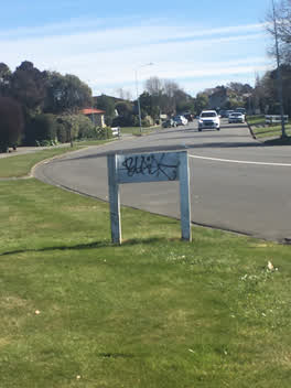 Graffiti, 44, Lakewood Drive, Burwood, Canterbury, 8083, New Zealand · 29 August 2020
Environment Canterbury / Canterbury Maps, Parks layer · refreshed 10 October 2026.
What stood on this ground before → · On the map →
Questions, answered briefly
How big is Wichita Reserve?
491 m² by the layer’s own polygon.
Where is Wichita Reserve?
Its centre falls inside Burwood, a centroid call, not a claim the whole park lies inside the outline.
What kind of place is Wichita Reserve?
A park or reserve.
Where does this record come from?
Environment Canterbury’s open Parks layer, kind, size and suburb read straight from it.