66 Richmond Hill Rd Christchurch 8081 Canterbury New Zealand
1 council report since August 2022, 1 carrying a photograph.
The green nearby
- Greenwood Park, 90 m to the edge · Regional · 279 ha
- Sumner Croquet Reserve, 118 m to the edge
- Brownlee Reserve, 335 m to the edge · 3 ha · playground, 24 pieces
- Sumner Beach, 403 m to the edge · Regional · 8 ha
- Sanscrit Reserve, 482 m to the edge · playground, 8 pieces
Parks within half a kilometre, measured to the boundary, the council’s open data. The whole roll is at /parks.
The civic shelf nearby
- Matuku Takotako / Sumner Library, 232 m away · Library
Libraries, halls and the rest within half a kilometre, the council’s open data.
On the doorstep
- Sumner Bowling Club, 159 m away · Clubs
- Fuse Youth Cafe, 208 m away · Cafés
- Red Snapper Fish & Chips, 211 m away · Fast food
- Clink Restaurant and Bar, 213 m away · Restaurants
Businesses within four hundred metres, measured at the pin, OpenStreetMap and the council directories.
The bus nearby
- Wakefield Ave near Nayland St, 242 m away · route 3
- Marriner St near Wakefield Ave, 298 m away · route 3
The closest Metro stops, within four hundred and fifty metres.
The tracks through here
- Walk and bike track through Richmond Hill, 423 m to the line · walk · bike
- Walk and bike track through Richmond Hill, 469 m to the line · walk · bike
Tracks whose line passes within half a kilometre, the council’s open data.
The named ground
Named places within 1.5 km of this address; the council’s own structure register, bridges, boardwalks and steps standing nearby, the open map’s record.
The remembered names nearby
- In Memory of Mary Jackson, 142 m away ·
IN MEMORY OF MARY JACKSON
· 2000 - In Memory of Ann Palmer, 164 m away ·
IN MEMORY OF ANN PALMER
· 2000 - Donated by E & U …, 168 m away ·
DONATED BY E & u … (Unreadable plate – very faint)
· 2000
Inscribed plaques within two hundred and fifty metres, the register’s pins, not surveyed spots. The whole roll is at /plaques.
What gets reported here
Photographed here 1 on record
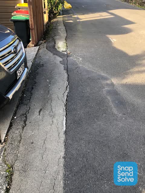
What’s on record
 Pavement - Damaged, 4 Aug 2022
Hi, as you will see from the attached photos we have some serious issues with the road and foot path outside our place at 66 Richmond Hill R
The civic layer
This ground votes in Heathcote ward, the Spreydon-Cashmere-Heathcote community board is its local layer. Ward lines don’t always follow suburb lines; this one is measured at the pin, not the suburb’s centre. The whole roll is at /wards.
Richmond Hill Rd Christchurch 8081 Canterbury New Zealand, the whole record → · Everything about Richmond Hill → · What stood on this ground → · On the map → · Street View → · From the air, RetroLens holds the Crown’s aerials back to 1936; search the address there →
Questions, answered briefly
1 council report on record since August 2022, most often pavement - damaged (1).
Richmond Hill, Christchurch, on Richmond Hill Rd Christchurch 8081 Canterbury New Zealand.
Nothing on the heritage register at this exact spot, the record around this ground →
Greenwood Park, 90 m to its edge, 279 ha.