30 Gamblins Road
7 council reports since April 2016, 7 carrying a photograph. The most-reported address on Gamblins Road.
From the air, then
Sourced from Canterbury Maps and partners. LINZ, CC BY 3.0 NZ. Each frame is cut from Environment Canterbury’s historic imagery MapServer for that decade, only where the Footprints layer names a CC BY survey (NZAM-covered spots stay out). RetroLens holds more Crown aerials →
The green nearby
- St Martins Park, 170 m to the edge · Sports ground · 2 ha · playground, 5 pieces
- Hansen Park, 325 m to the edge · Sports ground · 12 ha · playground, 63 pieces
- Palatine Native Reserve, 463 m to the edge
- Fifield Reserve, 475 m to the edge
- Heathcote Riverbank True Left, 494 m to the edge · 4 ha
Parks within half a kilometre, measured to the boundary, the council’s open data. The whole roll is at /parks.
On the doorstep
- St Martin's Community Centre, 74 m away · Venues & events
- Saint Martins Law, 75 m away · Lawyers
- Obsess Cafe - St Martins, 80 m away · Cafés
- St Martins Pharmacy, 80 m away · Pharmacies
Businesses within four hundred metres, measured at the pin, OpenStreetMap and the council directories.
The bus nearby
- St Martins Shops, 79 m away · route 27, the Orbiter (clockwise)
- St Martins Shops, 117 m away · route 27, the Orbiter (anticlockwise)
The closest Metro stops, within four hundred and fifty metres.
The tracks through here
- Walk and bike track through Saint Martins, 33 m to the line · walk · bike
- Walk and bike track through Saint Martins, 196 m to the line · walk · bike
- Walk and bike track through Saint Martins, 284 m to the line · walk · bike
- Walk and bike track through Saint Martins, 289 m to the line · walk · bike
- Walk and bike track through Saint Martins, 291 m to the line · walk · bike
Tracks whose line passes within half a kilometre, the council’s open data.
The named ground
Named water within 500 m of this address, measured to the line or the edge; the council’s own structure register, bridges, boardwalks and steps standing nearby, the open map’s record.
The remembered names nearby
- St. Martins Park Opened Dec, 194 m away ·
ST. MARTINS PARK OPENED DEC. 6 1952 BY THE MAYOR OF CHRISTCHURCH R.M. MACFARLANE ESC. / RE
· 2003
Inscribed plaques within two hundred and fifty metres, the register’s pins, not surveyed spots. The whole roll is at /plaques.
Renting nearby
new bonds in Saint Martins ran about $640 a week, $90 above the city median of $550, the suburb page keeps the rent record →.
What gets reported here
Photographed here 7 on record


What’s on record
 Pavement - General, 23 Aug 2026
 The construction fence is outside the boundary. the scaffolding is erected outside the boundary. the footpath is now narrowed obstructed and
 Pavement - Damaged, 21 Aug 2026
 still no removal and clean up of dirt and silt in kerb and channel. stuck under crossing plate so will flood in upcoming rain events.
 Pavement - Damaged, 20 Aug 2026
 The building site at 28 Gamblins Rd has caused a huge disruption to the footpath and street usage. The photo shows the muck that is hosed in
 Pavement - Damaged, 6 Aug 2026
 The contractors on this site are cowboys. They have wrecked the footpath and roadside. The footpath is broken and potholed, mud and puddles
 Sediment - Construction, 28 Jul 2026
 Builders scattering balls of polystyrene during building works. Microplastic pollution risk, these are in the storm water gulley
 Street Cleaning, 20 Jul 2026
 Considerable amount of soil on the road outside building site, left by trucks and diggers yesterday
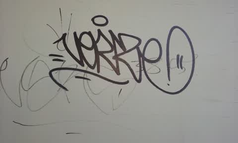
Graffiti, 22 Apr 2016
Graffiti on walk if busines Me Mood
Elsewhere on Gamblins Road
- 33A Gamblins Road, 7 reports
- 28 Gamblins Road, 7 reports
- 24A Gamblins Road, 6 reports
- 16 Gamblins Road, 6 reports
- 25 Gamblins Road, 4 reports
- 22 Gamblins Road, 4 reports
- 29 Gamblins Road, 3 reports
- 2 Gamblins Road, 3 reports
The street’s crash record
NZTA’s record names Gamblins Road in 7 crashes that hurt somebody since 2006, 1 seriously hurt, nobody killed.
The civic layer
This ground votes in Cashmere ward, the Spreydon-Cashmere-Heathcote community board is its local layer. Ward lines don’t always follow suburb lines; this one is measured at the pin, not the suburb’s centre. The whole roll is at /wards.
Gamblins Road, the whole record → · Everything about Saint Martins → · What stood on this ground → · On the map → · From the air, RetroLens holds the Crown’s aerials back to 1936; search the address there →
Questions, answered briefly
7 council reports on record since April 2016, most often pavement - damaged (3), street cleaning (1), sediment - construction (1).
Saint Martins, Christchurch, on Gamblins Road.
Nothing on the heritage register at this exact spot, the record around this ground →
St Martins Park, 170 m to its edge, 2 ha.