Barrington Street
353 reports at 32 addresses in Addington, the first in 2015, the latest 2026. 281 separate days somebody filed something about it.
Where it runs
Each report dot is the average of the spots reports were filed from, where reporters stood on Barrington Street, not the street’s surveyed line. The strong outline is Addington.
From the air, then
Sourced from Canterbury Maps and partners. LINZ, CC BY 3.0 NZ. Each frame is cut from Environment Canterbury’s historic imagery MapServer for that decade, only where the Footprints layer names a CC BY survey (NZAM-covered spots stay out). RetroLens holds more Crown aerials →
The addresses on it
- 468 Barrington Street, 67 reports
- 458 Barrington Street, 57 reports
- 465 Barrington Street, 39 reports
- 452 Barrington Street, 27 reports
- 467B Barrington Street, 24 reports
- 485 Barrington Street, 22 reports
- 469 Barrington Street, 15 reports
- 470 Barrington Street, 12 reports
- 479 Barrington Street, 10 reports
- 462 Barrington Street, 9 reports
- 477 Barrington Street, 7 reports
- 473 Barrington Street, 6 reports
- 450 Barrington Street, 6 reports
- 1/101/470 Barrington Street, 6 reports
- 475A Barrington Street, 5 reports
- 474A Barrington Street, 5 reports
- 472 Barrington Street, 5 reports
- 471 Barrington Street, 5 reports
- 481 Barrington Street, 4 reports
- 464 Barrington Street, 3 reports
- 489 Barrington Street, 2 reports
- 476 Barrington Street, 2 reports
- 474 Barrington Street, 2 reports
- 467A Barrington Street, 2 reports
- 467 Barrington Street, 2 reports
- 466 Barrington Street, 2 reports
- 454–470 Barrington Street, 2 reports
- 483 Barrington Street, 1 report
- 478 Barrington Street, 1 report
- 475 Barrington Street, 1 report
- 465–479 Barrington Street, 1 report
- 463A Barrington Street, 1 report
What got reported
- Graffiti & vandalism, 158 reports
- Rubbish & dumping, 74 reports
- Trees & parks, 51 reports
- Roads & footpaths, 39 reports
- Everything else, 13 reports
- Water & drains, 12 reports
- Vehicles & parking, 3 reports
- Animals & pests, 3 reports
Year by year
- 2015, 3 reports
- 2016, 6 reports
- 2017, 5 reports
- 2018, 12 reports
- 2019, 13 reports
- 2020, 7 reports
- 2021, 20 reports
- 2022, 43 reports
- 2023, 91 reports
- 2024, 97 reports
- 2025, 33 reports
In the written record
Archive documents carrying the street’s name: leads and citations, not verified history. 44 on the shelf; the 12 earliest:
- BIRTHS.. r; \ (Star, 19 April 1909)
· Papers Past,
…bennetts a daughter stillborn i marriagest jbbiley aldersleyaprii 12 at lin t coin house barrington street spreydon robert herwia youngest son of the late i thomas briley barrfield ounedin to flor en…
- THE ROLL OF HONOUR (Otago Daily Times 2-12-1915)
· Papers Past,
…on street, Birkenhead, Auckland, father). . Private FRED MACPHERSON RULE (Mrs K. Rule, 63 Barrington street, Spreydon, Christchurch). Private WM. EDGAR WILLIAMS (Mr T. Williams, Bunford, London, fathe…
- ROLL OF HONOUR. (Otago Daily Times 13-7-1917)
· Papers Past,
…PINHEY, STAFFORD N. (Mrs M. Pinhey, Mastorton, mother). READ, WILLIAM (Mr W. J. Read, 52 Barrington street, Spreydon, fatherr). (Juno 24.) BARKIS, ROBERT, Lance-corporal (Mrs K. O'Reilly, 173 Victori…
- House corner of Barrington Street and Rose Street, 1923 · Canterbury Stories,
- House corner of Barrington Street and Rose Street, 1923 · Canterbury Stories,
- Page 1 Advertisements Column 7 (Ellesmere Guardian, 28 October 1927)
· Papers Past,
…ch phone 2616 a britten proprietor sub-agent mrs g j fisher leeston j rhodes carrier 239 barrington st christchurch announces that he has instituted a goods cartage service christchurch to leeston so…
- Page 1 Advertisements Column 7 (Ellesmere Guardian, 04 November 1927)
· Papers Past,
…one 3842 head office no 11 dalgety buildings christchurch phone 8350 j rhodes carrier 239 barrington st christchurch announces that he has instituted a goods cartage service christchurch to leeston so…
- Page 1 Advertisements Column 6 (Ellesmere Guardian, 08 November 1927)
· Papers Past,
…the district in conjunction with his coal business charges moderate j rhodes carrier 239 barrington st christchurch announces that he has instituted a goods cartage service christchurch to leeston so…
- Page 1 Advertisements Column 6 (Ellesmere Guardian, 10 November 1927)
· Papers Past,
…price 1 each week old 13 a limited number of clients own eggs hatched twodes carrier 239 barrington st christchurch announces that he has instituted a goods cartage service christchurch to leeston so…
- Page 1 Advertisements Column 6 (Ellesmere Guardian, 15 November 1927)
· Papers Past,
…nextnovember 21 at 8 pm business disposal of funds j f hill chairman j rhodes carrier 239 barrington st christchurch announces that he has instituted a goods cartage service christchurch to leeston so…
- NEWS OF THE DAY (Evening Post, 05 October 1929)
· Papers Past,
…attle were brought in from the country on tuesday evening and were placed in a paddock in barrington street before being taken to the aldington saleyards in the early hours of wednesday morning they e…
- Barrington Street powerlines
· Canterbury Stories,
Powerlines and pole outside houses on Barrington Street. MED Historical Photographs…
The rest are a search away, the whole shelf, for the name →
The named ground
Named water within 150 m of a reported pin, measured to the line or the edge; the council’s own structure register, bridges, boardwalks and steps standing nearby, the open map’s record.
The crash record on it
NZTA’s record names Barrington Street in 66 crashes that hurt somebody since 2006, 1 person killed, 19 seriously hurt.
Its file in the papers
Papers Past records that surfaced when the archive searched for the street’s name, they answered the search; whether they are about this street is a reader’s call, at the link.
- CHRISTCHURCH. (Star, 08 August 1878) · Star,
- Page 3 Advertisements Column 2 (Star, 29 August 1904) · Star,
- Page 5 Advertisements Column 3 (Star, 18 November 1905) · Star,
- ROLL OF HONOUR (Evening Post, 19 June 1941) · Evening Post,
- ROLL OF HONOUR (Evening Post, 22 December 1941) · Evening Post,
- ROLL OF HONOUR (Evening Post, 03 January 1945) · Evening Post,
As it was reported


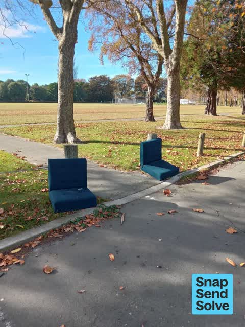


The latest on it
- Abandoned Vehicle, 479 Barrington St,
- Traffic Signals, 465–479 Barrington St,
- Road Signage, 476 Barrington Street,
- Graffiti on a fence, building or structure, 452 Barrington Street,
- Dumped Rubbish, 468 Barrington Street,
- Graffiti on a playground or in a park, 468 Barrington Street,
- Road Signage, 467B Barrington Street,
- Graffiti on a playground or in a park, 468 Barrington Street,
- Graffiti on a road, footpath or bridge, 452 Barrington Street,
- Dumped Rubbish, 1/101/470 Barrington Street,
- Litter, 450 Barrington St,
- Roads - General, 1/101/470 Barrington Street,
- Graffiti on a road, footpath or bridge, 465 Barrington Street,
- Dumped Rubbish, 468 Barrington Street,
- Dumped Rubbish, 470 Barrington Street,
Questions, answered briefly
In Addington, Christchurch, New Zealand.
353 reports at 32 addresses, most often graffiti & vandalism (158), rubbish & dumping (74), trees & parks (51).
2015, the record covers 281 separate days somebody filed something about it, through 2026.
Every street the archive knows → · Addington → · This street as a feed →