2 Elgin Street, Sydenham
20 reports on record since October 2016 · 18 with photographs. The most-reported address on Elgin Street. Indicative rating valuation and school zones, hazards, bin day and what stood here before.
What gets reported here
Photographed here 18 on record



Reported here
 Flooding —
 drain blockled a lot of water this corner
 Water General —
 Several issues here. There was. Obviously a water repair of some kind.It has been done incorrectly. Water still seeping into stormwater fr
 Graffiti on a fence, building or structure —
 Cream paint tags on locked door on building on Durham Street South by 2 Elgin Street.
 Graffiti on a fence, building or structure —
 Colombo mall carpark
 Graffiti on a fence, building or structure —
 Green paint tag on building door at about 20 Durham Street South.
 Road Signage —
 White paint tags on both sides of this road sign near 20 Durham Street South.
 Graffiti somewhere else —
 Steps required for side wall
 Graffiti on a sign, mural or public art —
 White paint tag on road sign on Durham Street South.
 Graffiti on a sign, mural or public art —
 EKOE black paint tag on Colombo carpark sign on Durham Street South facing the footpath.
 Pavement - Damaged —
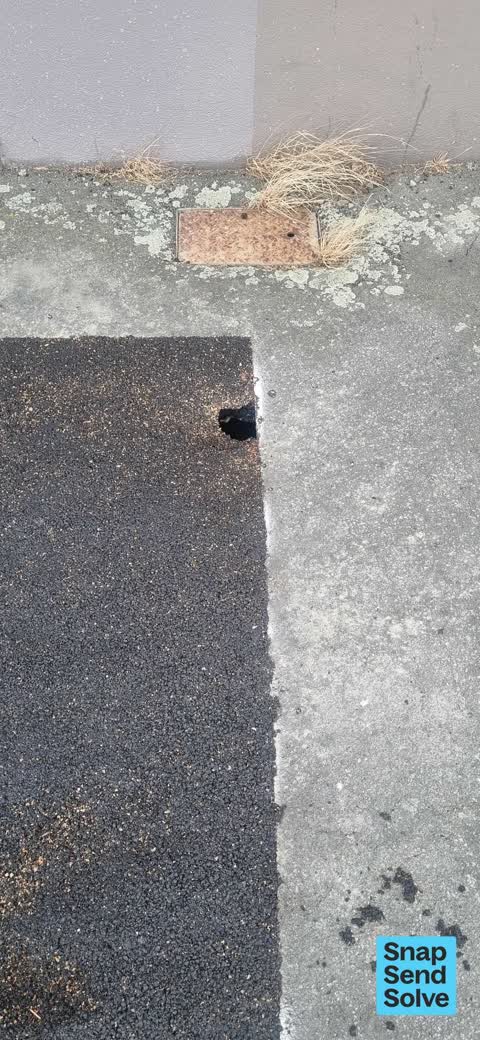
 Pothole on path to level fill & seal
 Overgrown Vegetation —
 Weeds removal from path & cracked paint surfaces on building
 Pavement - Damaged —
 Driveway entrance berm to replace
 Pavement - Damaged —
 Old driveway entrance to remove & level to path with berm required
 Pavement - General —
 Old signage to remove from path & level fill & seal
 Pavement - Damaged —
 Missing berm , missing damaged storm water outlet pipes & potholed path without garden border to level fill & seal path. Missing street gard
- Pavement - Damaged —
- Graffiti —
 Roading/Streets —
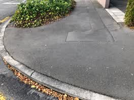
 Hi there, the footpath outside our Coffee Culture premises at 2 Elgin St has deteriorated since the EQ. A number of the chases etc are uneve
Graffiti —
Markings in the wall
Graffiti —
Also reported on Elgin Street
- 6 Elgin Street — 18 reports
- 33 Elgin Street — 18 reports
- 29 Elgin Street — 12 reports
- 5 Elgin Street — 11 reports
- 13 Elgin Street — 11 reports
- 27a Elgin Street — 7 reports
- 19 Elgin Street — 7 reports
- 23 Elgin Street — 4 reports
The street’s crash record
NZTA’s record names Elgin Street in 16 crashes that hurt somebody since 2006 — 2 seriously hurt, nobody killed.
The green nearby
- Sydenham Park — 172 m to the edge · Sports ground · 5 ha
- Buchan Playground — 301 m to the edge
- Antigua Reserve — 446 m to the edge
Parks within half a kilometre, measured to the boundary — the council’s open data.
On the doorstep
- The Tucker Shop — 33 m away · Business
- Coffee Culture Roastery on Durham — 34 m away · Cafés
- Hello Sunday — 34 m away · Restaurants
- 5th Street — 46 m away · Restaurants
Businesses within four hundred metres, measured at the pin — OpenStreetMap and the council directories.
The bus nearby
- Sydenham Shops — 233 m away · route 1, route 8, route 44
- Colombo St near Wordsworth St — 262 m away · route 1, route 8, route 44
The closest Metro stops, within four hundred and fifty metres.
The tracks through here
- Walk and bike track through Sydenham — 234 m to the line · walk · bike
- Walk and bike track through Sydenham — 469 m to the line · walk · bike
Tracks whose line passes within half a kilometre, measured to the line itself — the council’s open data.
The named ground
Named water within 500 m of this address, measured to the line or the edge; Named places within 1.5 km of this address — the open map’s record.
The remembered names nearby
- Sydenham Park plaque — 212 m away
Inscribed plaques within two hundred and fifty metres — the register’s pins, not surveyed spots. The whole roll is at /plaques.
Renting nearby
new bonds in Sydenham ran about $518 a week — $32 below the city median of $550 — the suburb page keeps the rent record →.
What was here — Former Dwellings and Setting, Blackheath Place
188 m away · 71 Durham Street South · located to ±30 m · the place’s own record →
On the register. Nothing researched here yet.
The civic layer
This ground votes in Heathcote ward — the Spreydon-Cashmere-Heathcote community board. Ward lines don’t always follow suburb lines; this one is measured at the pin, not the suburb’s centre.
What stood on this ground → · On the map → · From the air — the Crown’s aerials back to 1936; search the address on RetroLens →
Questions, answered briefly
20 council reports on record since October 2016 — most often pavement - damaged (5), graffiti on a fence, building or structure (3), graffiti (3).
Sydenham, Christchurch — on Elgin Street.
The heritage register names a place at or beside it — Former Dwellings and Setting, Blackheath Place.
Sydenham Park — 172 m to its edge, 5 ha.