373 Moorhouse Avenue, Sydenham
28 reports on record since November 2015 · 24 with photographs. The street’s heaviest record is 166 Moorhouse Avenue — 36 reports on file. Indicative rating valuation and school zones, hazards, bin day and what stood here before.
What gets reported here
Photographed here 24 on record


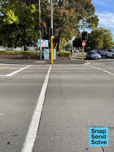


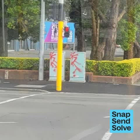

Reported here
 Graffiti on a traffic light pole or cabinet, or wa —
 graffiti on traffic light pole
 Graffiti on a traffic light pole or cabinet, or wa —
 Graffiti on traffic signal cabinet, corner Moorhouse Avenue/ Barbadoes Street CBD ChCh.Thanks. Ple
- Road Blockage —
Traffic management for cyclists along Moorehouse ave thru these road works is non existent. there is plenty of room to continue a dedicated
 Damaged Street Sign —
 Road sign damaged. Moorhouse Avenue intersection, Waltham Road/ Barbadoes Street CBD ChCh. Thanks. Please notify me of update on SSS repor
- Graffiti on a traffic light pole or cabinet, or wa —
Graffiti ( black) on 2 traffic signal cabinets, 373 Moorhouse Avenue corner Barbadoes Street Christchurch. No photo, as I was driving.
 Graffiti on a traffic light pole or cabinet, or wa —
 Traffic light cab
 Dumped Rubbish —
 Been there for over a month, on the Moorhouse side, where it meets Barbadoes.
 Graffiti on a cabinet, pole or railway asset —
  General Request —
  Graffiti on a cabinet, pole or railway asset —
 Taking on poles and boxes on the corner of Moorehouse and Barbados
 Graffiti somewhere else —
  Vandalism - General —
 Graffiti on back of cabinets
 Graffiti somewhere else —
 - Graffiti on a cabinet, pole or railway asset —
Graffiti (red) on 2 grey? cabinets, corner of Barbadoes Street ( city side ) & Moor house Avenue.Chch. No photo as I was driving.
 Graffiti somewhere else —
 2 blue traffic control cabinets have graffiti on them
 Graffiti on a cabinet, pole or railway asset —
 Red And orange paint tags on 2 traffic controllers at the corner of Moorhouse Avenue and Barbadoes Street.
 Graffiti on a cabinet, pole or railway asset —
 Black, red and orange paint tags all over 2 traffic controllers at the corner of Moorhouse Avenue and Barbadoes Street.
 Graffiti on a fence, building or structure —
 Tags on boxes
 Graffiti on a fence, building or structure —
  Damaged Street Sign —
 P120 has been romped after re sealing footpath . Sign needs to be after the yellow lines on the north side of moorhouse . Pole and sign need
 Graffiti on a road, footpath or bridge —
  Vandalism - General —
  Vandalism - General —
 Graffiti —
Roading/Streets —
- Graffiti —
Graffiti —
Roading/Streets —
Add maybe 5-10 more seconds onto right turning arrow onto Waltham rd from Morehouse ave to elliminate rush hour congestion.
Also reported on Moorhouse Avenue
- 166 Moorhouse Avenue — 36 reports
- 386 Moorhouse Avenue — 29 reports
- 392 Moorhouse Avenue — 19 reports
- 297 Moorhouse Avenue — 19 reports
- 372 Moorhouse Avenue — 17 reports
- 367 Moorhouse Avenue — 16 reports
- 450 Moorhouse Avenue — 14 reports
- 287 Moorhouse Avenue — 14 reports
The street’s crash record
NZTA’s record names Moorhouse Avenue in 211 crashes that hurt somebody since 2006 — 5 people killed, 32 seriously hurt.
The green nearby
- Washington Way Reserve — 30 m to the edge · Sports ground
- Gasson Reserve — 251 m to the edge
- Science Alive Reserve — 303 m to the edge
- Wilson Park — 366 m to the edge
Parks within half a kilometre, measured to the boundary — the council’s open data.
The civic shelf nearby
- St Asaph — 444 m away · Car park
Libraries, halls and the rest within half a kilometre — the council’s open data.
On the doorstep
- Chubb — 109 m away · Security
- BDL — 110 m away · Printer Ink
- Kennards Hire — 116 m away · Plant Hire
- ARA Health Centre — 125 m away · Doctors & clinics
Businesses within four hundred metres, measured at the pin — OpenStreetMap and the council directories.
The bus nearby
- Moorhouse Ave near Washington Wy — 68 m away · route 8, route 27, route 140
- Moorhouse Ave near Madras St — 183 m away · route 140
The closest Metro stops, within four hundred and fifty metres.
The tracks through here
- Walk and bike track through Sydenham — 8 m to the line · walk · bike
- Walk and bike track through Sydenham — 8 m to the line · walk · bike
- Walk and bike track through Sydenham — 11 m to the line · walk · bike
- Walk and bike track through Sydenham — 149 m to the line · walk · bike
- Walk and bike track through Sydenham — 296 m to the line · walk · bike
Tracks whose line passes within half a kilometre, measured to the line itself — the council’s open data.
The named ground
Named places within 1.5 km of this address — the open map’s record.
Renting nearby
new bonds in Sydenham ran about $518 a week — $32 below the city median of $550 — the suburb page keeps the rent record →.
What was here — Former Grosvenor Hotel and Setting
217 m away · 367 Moorhouse Avenue · located to ±15 m · the place’s own record →
On the register. Nothing researched here yet.
The civic layer
This ground votes in Central ward — the Papanui-Innes-Central community board. Ward lines don’t always follow suburb lines; this one is measured at the pin, not the suburb’s centre.
What stood on this ground → · On the map → · From the air — the Crown’s aerials back to 1936; search the address on RetroLens →
Questions, answered briefly
28 council reports on record since November 2015 — most often graffiti on a cabinet, pole or railway asset (5), graffiti on a traffic light pole or cabinet, or wa (4), vandalism - general (3).
Sydenham, Christchurch — on Moorhouse Avenue.
The heritage register names a place at or beside it — Former Grosvenor Hotel and Setting.
Washington Way Reserve — 30 m to its edge.