The port’s first streets
The port’s front: from the pilgrims' landing site along Norwich Quay, up London Street’s shopfronts, and back past the gaol site and the graving dock. A steep half-day; the register is dense here.
The walk, as a line
Straight between pins, the streets run longer. Every numbered pin opens that place’s own record.
The stops, in order
- Pilgrims Landing Site and Setting, 7 Norwich Quay · 42 unread leads
The Pilgrims' landing site, where the First Four Ships' passengers stepped ashore.
- Former Harbour Board Office and Setting, 5 Norwich Quay · Heritage NZ list 1815 · 41 unread leads
The former Harbour Board office, the port’s own front office.
- Signal Box and Setting, 1 Norwich Quay · 38 unread leads
The signal box at the quay’s foot.
- Commercial Building and Setting, 14 London Street · 26 unread leads
London Street’s listed shopfronts start here, keep walking up the street.
- Commercial Building and Setting, 47 London Street · 20 unread leads
Another London Street storefront, the whole strip is a catalogue.
- Former British Hotel and Setting, 10 Oxford Street · 41 unread leads
The former British Hotel on Oxford Street.
- Former Lyttelton Gaol Site, 26D Oxford Street · Heritage NZ list 7353 · 41 unread leads
The gaol site, the prison the town was famous for is a listing, not a building.
- Graving Dock and Setting, 45 Godley Quay · Heritage NZ list 4389 · 42 unread leads
The graving dock on Godley Quay, the dry dock cut into the harbour’s edge.
What the register built on the way
Council structures within about 30 m of the stop-to-stop line, the bridges, steps and shelters the route passes. Site names are the register’s own.
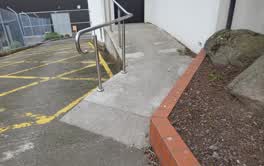 A ramp at Lyttelton Library, 5.9 m long · built 1899 7 m off the line
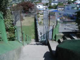 A set of steps at Oxford Street Reserve, built 2008 15 m off the line
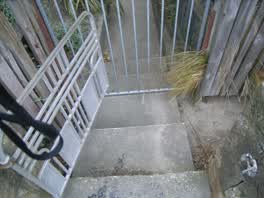 A set of steps at Sumner Road Gardens, 2 m long · built 2008 16 m off the line
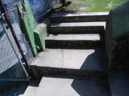 A set of steps at Oxford Street Reserve, 2 m long · built 2008 19 m off the line
The reports along it
2,235 council reports pinned within 150 m of the line, most often Graffiti & vandalism and Roads & footpaths, 1,900 with a photograph. A pin is where a reporter stood, not a claim about the place itself.
 Pothole
 Playground Equipment
 Facility - General Request
 Graffiti on a fence, building or structure
 Public Toilet
 Overgrown Vegetation
 Road Signage
 Graffiti on a fence, building or structure
 Graffiti on a sign, mural or public art
 Park - General Request
Questions, answered briefly
The port’s front: from the pilgrims' landing site along Norwich Quay, up London Street’s shopfronts, and back past the gaol site and the graving dock. 8 listed places, 2.0 km as the line runs, Lyttelton.
Pilgrims Landing Site and Setting (7 Norwich Quay) to Graving Dock and Setting (45 Godley Quay), the order is a suggestion, not the only way round.
Every one, each pin is a row in the district plan’s heritage schedule, and each opens the place’s own sourced record here.
2.0 km measured straight between the pins, the streets run longer, and the stops deserve a pause each.
The record behind this
Every stop is a row in the district plan’s heritage schedule, held here as the register’s own layer. The order and the notes are ours, the listings are the council’s and Heritage New Zealand’s. "Setting" is the register’s word for the ground a listing covers.
The rest of the register here: Lyttelton
The same ground today: Lyttelton
This page as markdown: /walks/lyttelton-harbour.md · the route as data: /walks/lyttelton-harbour.geojson · on the live map: the walks layer.